THIS WEEK’S FEATURED WALKS:


ALL TRAILS

DRAGON’S BACK WALK (5 MILES)
Want to feel like you’ve spent the day in Middle Earth? This route’s for you.

Start: Hollinsclough, SK17 0RH
Distance: 5 miles
Ascent: 1,000 feet
Duration: allow approx. 2 hours
Navigation: follow step-by-step

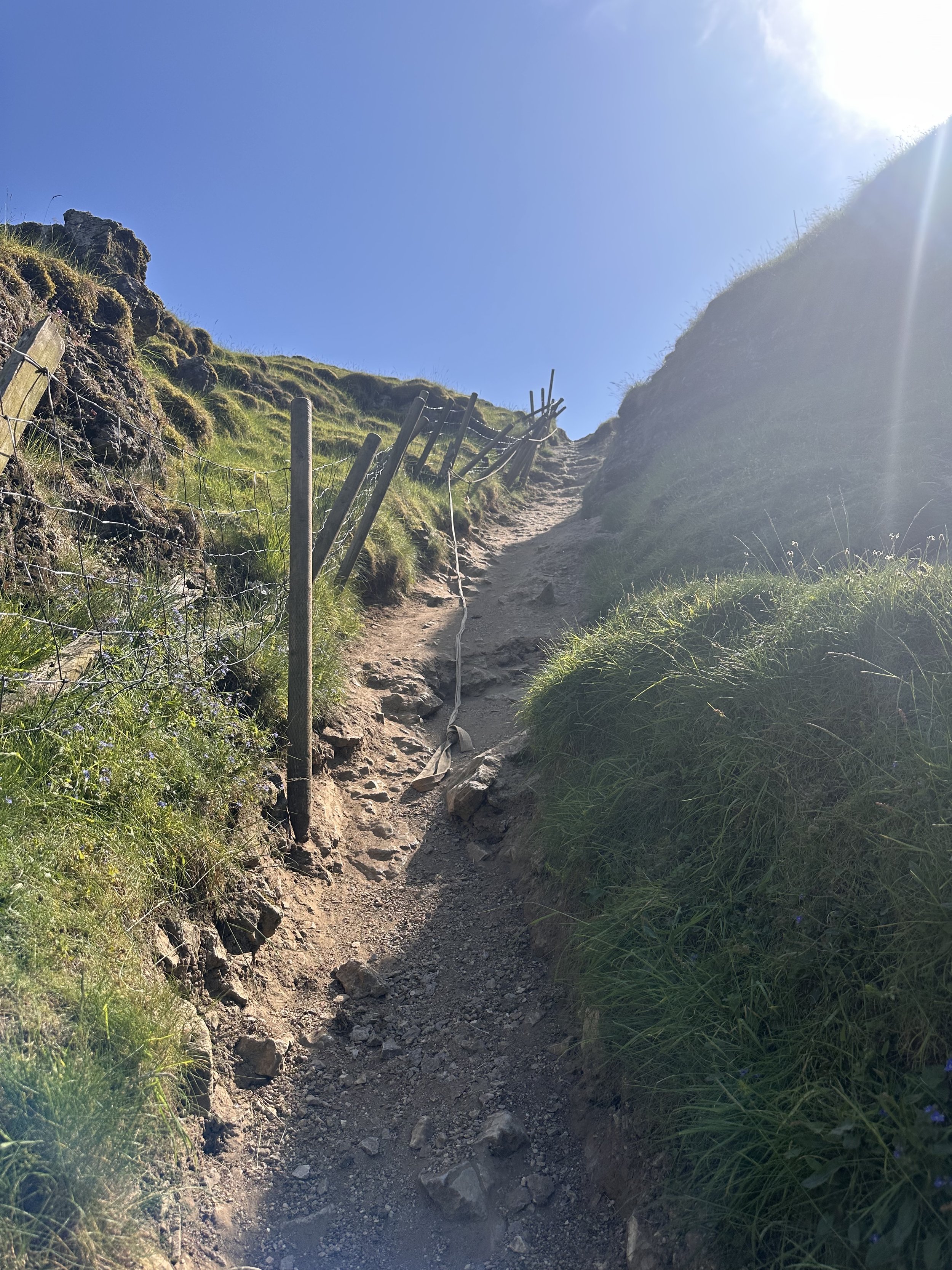
Starting and finishing in the pretty hamlet of Hollinsclough, this walk has it all: magnificent views across the Staffordshire and Peak District wilds, paths criss-crossed with ancient stone walls, and summits galore… taking you through the breath-taking landscapes of the famous Dragon’s Back over the tops of Chrome Hill (424m), before meandering back up Parkhouse Hill (360m).
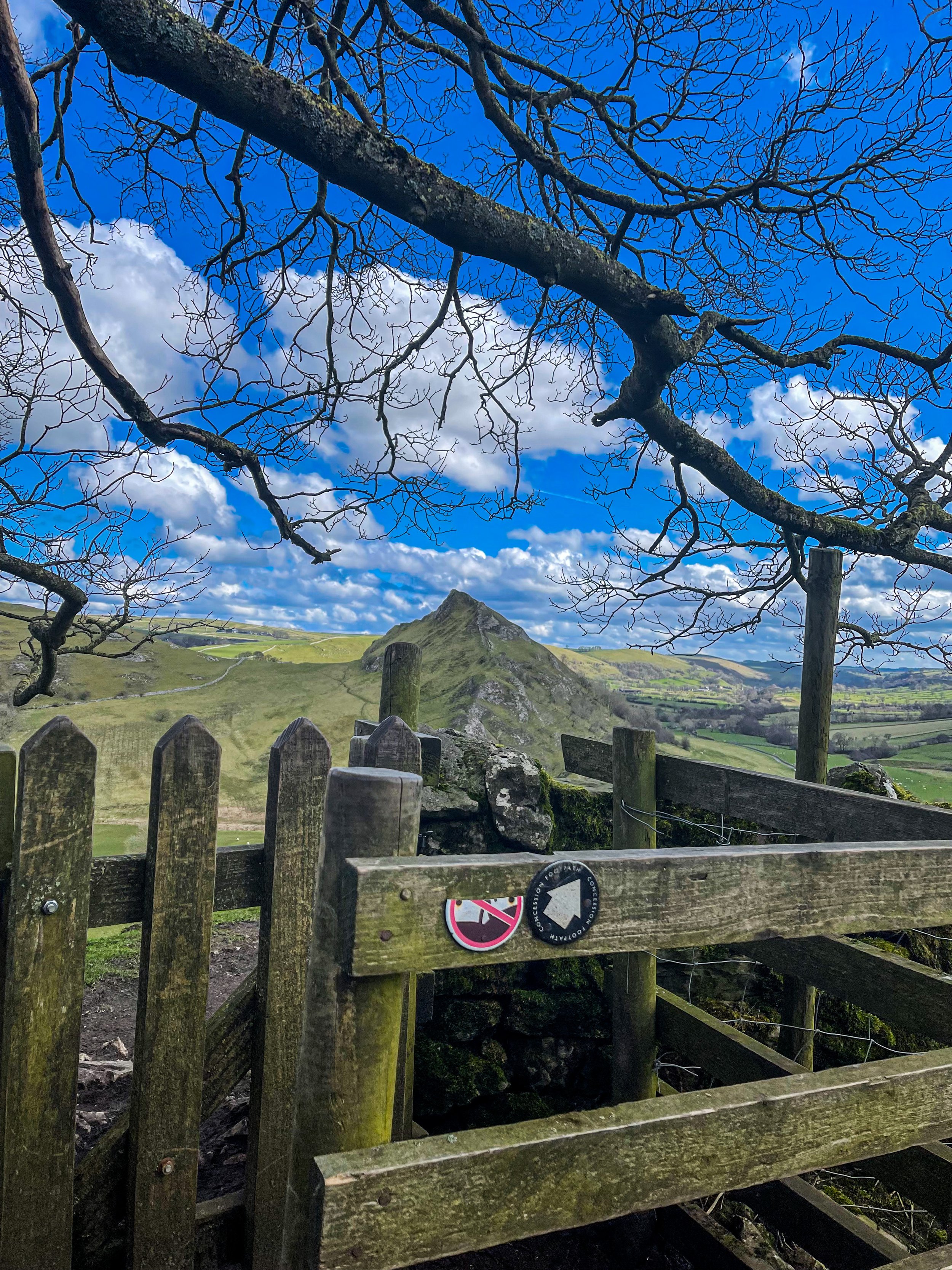
From here, you descend through untouched farmland and idyllic country lanes to make the return back to Hollinsclough.
With challenging terrain in places, our route to the summit of Parkhouse Hill should only be taken on if you’re confident at scrambling. There’s free street parking in the village but spaces are limited to so plan ahead if you’re arriving by car.

The views of the landscapes surrounding are sure to take your breath away at every part of this route. But the real highlight for us came in the form of a wonderfully idyllic pitstop, The Honesty Shop.
This perfectly stocked café-come-hut-come-shop has all your refuel needs covered, with hot drinks, sweet treats and fresh local produce aplenty. The Honesty Shop has no staff and relies solely on the good nature of passers-by to do the right thing - a comforting reminder that we were far away from the hustle of the city.

The walk can be shorted by cutting out the final ascent over Parkhouse Hill or extended by following your nose to the summit of High Wheeldon.

Another option is to start at The Quiet Woman pub in Earl Sterndale, not far from Buxton. Unsurprisingly, the many routes surrounding the limestone reef knolls of Chrome and Parkhouse Hills make for magnificent views throughout.

BAMFORD AND STANAGE EDGE CIRCULAR
Breathtaking scenery? Check. Two iconic Peak District landmarks in one walk? This route has you covered…

Start: Heatherdene Car Park, S33 0BY
Distance: 7 miles
Duration: 3 hours
Elevation: 1,150 feet
Difficulty: Moderate
Navigation: Download the GPX file here
This scenic Bamford Edge walk also visits Stanage Edge, taking in some of the best views in the Peak District.
Walk Highlights
Bamford Moor
As you ascend from Heatherdene, Bamford Moor presents itself with rugged landscapes and untamed beauty. This expanse of open moorland offers panoramic views, babbling brooks, and a stone circle dating back to The Bronze Age. Keep your camera ready!
Stanage Edge
Situated north of Hathersage, Stanage Edge is a popular place for walkers and for rock climbing with stunning views of the Dark Peak moorlands and the Hope Valley. The gritstone edge stretches for approximately 4 miles and featured in the classic film ‘Pride & Prejudice’ starring Keira Knightley.
Bamford Edge
Bamford Edge is an overhang of gritstone that sticks out over the beautiful Bamford Moor. The ridge is renowned for its distinctive rock formations, including the photogenic 'Great Tor'. It lies elevated on the moor, close to the quintessential Derbyshire village of Bamford in the Peak District National Park.
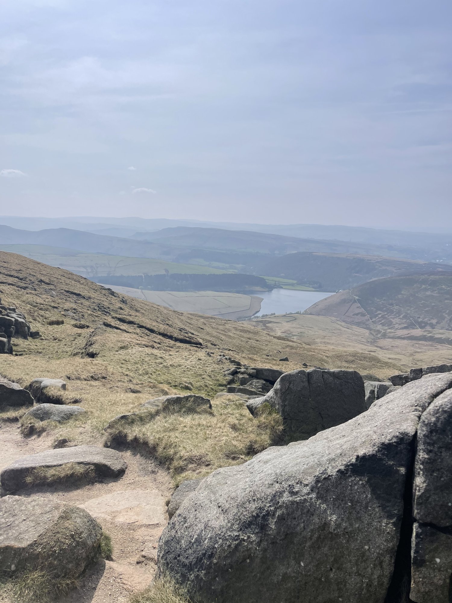
Bamford Edge is approximately 1381 ft above sea level or 420 metres high. From the top, you get some of the best views of Ladybower Reservoir, Win Hill, Lose Hill, The Great Ridge, Crook Hill, and Hope Valley — all from just a relatively short walk to the top.
It’s extremely popular with rock climbers, walkers, and those wanting to get some fabulous photos on an iconic overhanging ledge.
Tips
Facilities are limited on this one. You’ll find public toilets available at the start of the walk (Heatherdene Car Park) and a cafe at nearby Derwent Reservoir if you’re looking to extend the route.
Check the weather: The weather atop the moor can be unpredictable. Dress in layers and be prepared for changes.
Respect the environment: The Peak District is a protected area. Stick to paths, and don't disturb wildlife.
Arrive early: Heatherdeane Car Park gets incredibly crowded during the weekend, visit off-peak where you can.
Catch a sunset: Looking for a shorter walk? Check out our Bamford Edge sunset variation below, clocking up just 3 miles.
Plan ahead: Ensure you have enough water, snacks, and a map. Mobile signal can be patchy, so physical maps are handy.
Leave the white trainers at home! The area around the moors can get incredibly boggy — so definitely bring your boots for this one.
Best time to visit: Early morning or late afternoon to avoid the crowds and catch the golden light.
Safety first: The edges can be slippery, especially after rain. Wear sturdy boots and watch your step.
Leave no trace: Preserve the beauty of the Peaks. Take your rubbish with you and stick to the paths.
SUNSET WALK VARIATION

Short on time, or simply want to head up for sunset? This short loop up to Bamford Edge is a great alternative. The walk up to the edge only takes approx. 20 minutes with just a short ascent up to the ridge — the perfect route to watch the sun set over Ladybower.
Tip: The walk up can get incredibly boggy after rainfall, so definitely bring your boots for this one.
Bamford Circular Walk

Distance: 3.53 miles
Elevation: 650 feet
Duration: 1.5 hours
Start: Heatherdene Car Park, S33 0BY
Navigation: follow the route here
Despite clocking up just a few miles overall, this Bamford loop offers some of the best views in the Peak District. With just a short climb at the start, you walk towards Bamford Edge and are instantly rewarded with incredible views of Ladybower and Derwent Reservoirs.
Just opposite, you’ll also find another great vantage point in the form of Win Hill. The easygoing nature of this route makes it a popular location for sunrise and sunset.
Up top, you’ll be spoilt choice if you’re looking to extend the walk—with the option to include both Ladybower and Derwent Reservoirs if you prefer to skip the climb and soak up the views at the bottom.
Looking for more walks like this one? Check out our latest adventures on Instagram

SOLOMON’S TEMPLE WALK
An short but idyllic in Buxton boasting impressive views

Perched high over the idyllic town of Buxton lies a monument like no other. Solomon’s Temple is Buxton’s very own folly. The Victorian viewpoint tower built in 1896 stands proudly atop the summit of Grin Low - and, unlike the true spirit of a folly (which usually have no practical purpose whatsoever), Solomon’s Temple actually occupies a site of ancient significance.

It’s built on the site of a tumulus, a Neolithic burial chamber, and replaced the ruins of an earlier structure built by Solomon Mycock. Before the existing tower was built, the area was excavated and contained several skeletons from the Beaker period - spooky stuff.
Grin Low, which Solomon’s Temple is built on, was the main location for the early Buxton lime industry. The large, oddly shaped mounds you see on the walk up to the summit are widespread remains of over 100 large ‘pudding’ lime kilns which date from the 17th-19th centuries.

And as for the route itself? Well, it’s one of our favourite walks this side of the Peaks, that’s for sure.
With your choice of woodland trails leading from Poole’s Cavern to the summit, you’re sure to be met with beautiful landscape and spectacular views whichever way you venture.

Fancy giving it a go? Follow the route here

ERRWOOD HALL LOOP, GOYT VALLEY
Panoramic views, magical woodlands and peaceful picnic spots are just some of the reasons you’ll want to head to Goyt Valley — and at just 3 miles for a round trip, you won’t find a better local short walk than this one…

Start: Errwood Hall Car Park, SK11 0AR
Distance: 3 miles
Elevation: 500 feet
Duration: 1-2 hours
Navigation: follow the route here

This relaxed Peak District walk is beautiful in any season, but the way the woods are painted with gorgeous auburn hues come late September should make this route appear high on your list of autumn woodland walks.
Lying just a few miles northwest of Buxton, Goyt Valley is magical place — one that’s gained popularity from visitors since Victorian times.
Once a prosperous and industrious community, the signs of a time gone by are all but extinct, bar from the ruins of Errwood Hall. Back in 1937, the construction of Fernilee Reservoir completely changed this beauty spot’s landscape, but the area remains a wonderfully peaceful place to visit to this day.
Walk Overview
This leisurely three-mile walk takes in three of the most historic sites in this part of the Goyt Valley; the ruins of Errwood Hall, the hilltop cemetery of the Grimshawe family who lived here from around 1840 to 1930, and St Joseph’s Shrine, the small circular stone building dedicated to the Spanish companion of Mrs Jessie Grimshawe. From here the walk ascends a gentle slope to reach the summit of Foxlow Edge before returning to Errwood Hall carpark.

Errwood Hall: A Glimpse into the Past
Errwood Hall, now a ruined site, was once the centerpiece of the Grimshawe estate. Constructed in the 1830s by Samuel Grimshawe, this grand mansion boasted Victorian Gothic architecture and stunning views of the Goyt Valley. The Grimshawe family, who resided here from 1840 to 1930, played a significant role in the area's history.
During its heyday, Errwood Hall hosted lavish gatherings and social events, but tragedy struck in 1930 when the estate was demolished due to financial difficulties. Today, the haunting remains of Errwood Hall stand as a testament to a bygone era, inviting visitors to explore its enchanting grounds.

Goyt Valley Highlights
Pym Chair
Folklore more your thing? Local legend has it that a highwayman called Pym used to lay in wait to ambush those who used the old packhorse route, hence the name Pym Chair given to one of the peaks in this mesmerising landscape.
Shining Tor Trig Point
Shining Tor, the highest point in Cheshire, is often included in walks through Goyt Valley… because if you can bag a few trigs in one walk, why wouldn’t you?

Fancy giving this one a go? Follow the route here
HATHERSAGE - FAIRY WOOD WALK
Seek some relief from the windy peaks and enjoy this short walk that’s perfect for a winter’s day…

Start: Oddfellows Road, Hathersage, S32 1DD
Distance: 4.63 miles
Duration: 2 hours
Elevation: 800 feet
Difficulty: Easy
Navigation: Download the GPX file here
Starting and ending in quaint Peak District village, Hathersage, this is a perfect route if you prefer your walks to start and end in a country pub or cosy cafe.
The route follows well-made paths up and out of the village, past the church, through beech woodlands, and up over the tops towards Stanage Edge, before meadnering back down into the village on coutnry lanes.

Hathersage
This picturesque village in the Derbyshire Dales is adorned with stone cottages, a babbling brook, and welcoming faces aplenty. Take a moment to explore the local shops, cafés, and St Michael’s Church, where you can take a visit to Little John’s Grave.

A Legendary Wander: Discovering Little John’s Grave
Our walk leads you past St. Michael's Church at the start of the route, where you’ll find the final resting place of Little John, legendary companion to Robin Hood. If rich folklore and enchanted woodlands sounds like your idea of a great day out, this walk is for you.

Stanage Edge
Leaving the Fairy Wood behind, our route ascends towards the moors at the base of Stanage Edge. This iconic gritstone escarpment offers breathtaking panoramic views of the surrounding landscapes.

Good-to-knows
Facilities: Parking, Public Toilets, Cafes and Pubs
Parking: Parking is pay and display at Oddfellows Road, S31 1DD
Public Transport: Manchester Piccadilly > Hathersage, 56 mins.

Fancy giving this one a go? Follow the route here

ROBIN HOOD’S STRIDE AND NINE LADIES STONE CIRCLE
Mystery and myth await on this 7 mile adventure to some of Derbyshire’s best landmarks…

Start: The Druid Inn, Birchover, DE4 2BL
Distance: 6.81 miles
Elevation: 925 feet
Duration: 2.5 hours
Difficulty: Easy
Navigation: Follow the route here
As witchy walks go, this 7 mile route in The Peak District is up there.
Where else can you enjoy a pint at a pub named The Druid Inn shortly after visiting a Bronze Age stone circle?
This easy-going walk has slowly become one of our all-weather favourites — atmospheric in winter, magical in spring, and a great place to pause in summer.
Birchover Village
The charming village of Birchover is nestled in the heart of the Peak District National Park, between the towns of Matlock and Bakewell in the county of Derbyshire. Birchover is one of the oldest recorded villages in the Peak District, having been referenced in the Domesday Book of 1086. As Peak District villages go, Birchover doesn’t garner quite the tourism and accolade as places like Castleton or Edale… making it perfect for those seeking a place to pause in the Peaks.
Birchover lies to the southeast of the Peak District National Park. Its location and proximity to Bakewell make it an easy place to stop at if you’re considering a visit to the very popular Bakewell area, for attractions such as Chatsworth House. The region around Birchover houses many interesting geological features such as Hermits Cave and Robin Hood’s Stride. They are easily explored and enjoyed on this Birchover and Stanton Moor circular walk.

Robin Hood’s Stride
From the small lay-by parking area, our Birchover walk starts with a short climb up to Robin Hoods Stride and Hermits Cave. This forms a quick out and back. You can choose to visit at the start or end of your walk. But for us, we like to save the best ‘til last… and we’re suckers for a good old stone circle.
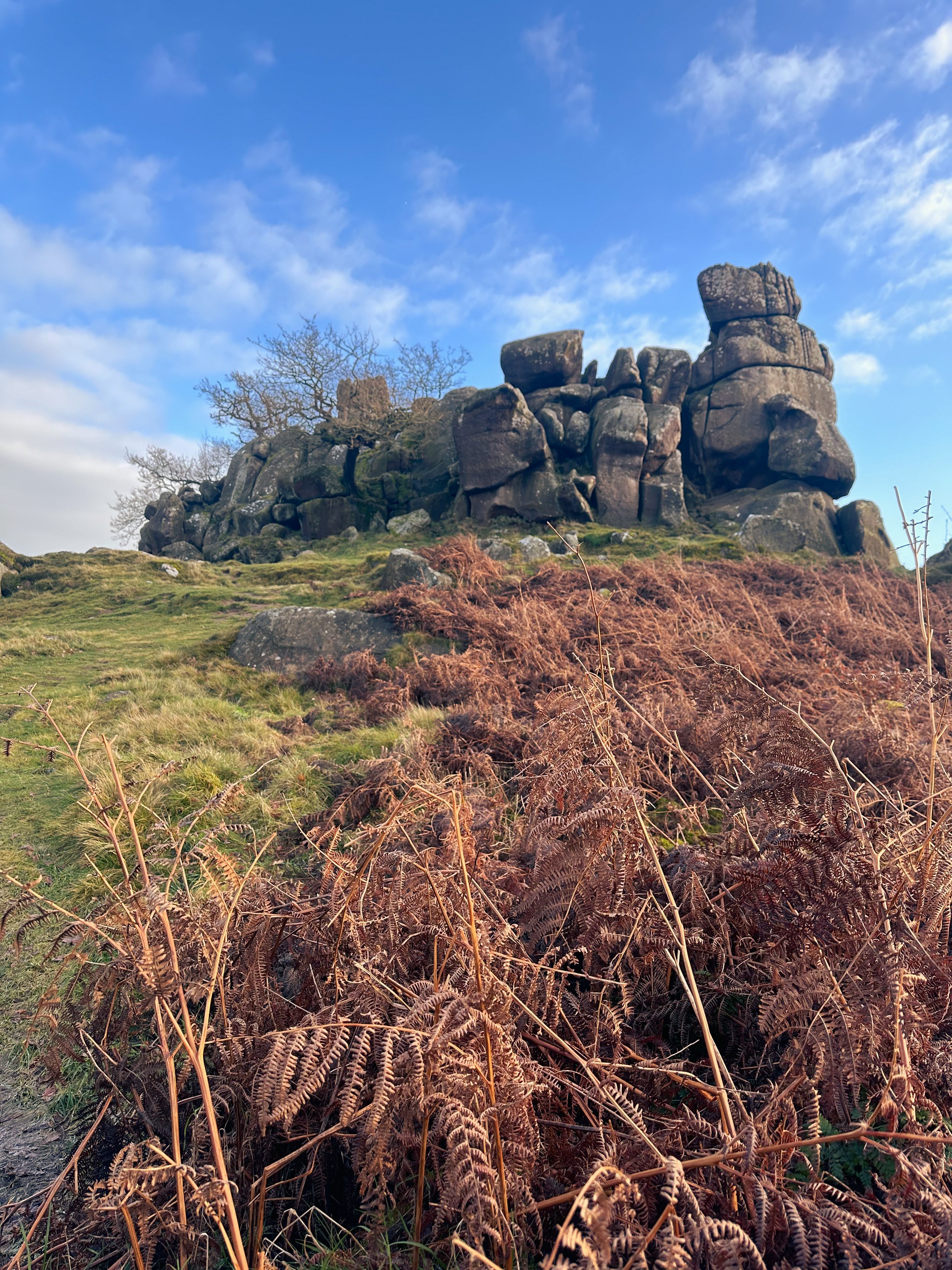
Cross the road and head uphill through open fields and charming woodlands. At the top, you'll find Robin Hood's Stride. The impressive pile of gritstone boulders, aka Mock Beggar’s Mansion, is an invitation for a bit of adventurous scrambling. Alternatively, soaking in the views from the base is just as rewarding.
From Robin Hood's Stride, gaze out at Bradley Rocks. Film buffs might recognise both locations, as they were featured in The Princess Bride.
Once you've taken in the charm of Robin Hood's Stride, it's time to explore Hermits Cave.
Hermits Cave
A short distance to the west of Robin Hoods Stride is Hermits Cave. Located at Cratcliffe Tor is a shallow shelter carved into the side of the rockface. This is Hermits Cave. Inside the hollow on the side of the hillside is a stone bench that looks like a bed and a carving of a crucifix. The carving in Hermits Cave is thought to date back to the 13th or 14th century.

Nine Ladies Stone Circle
The name Nine Ladies comes from the folk tradition of nine women dancing on the Sabbath being turned to stone. The stones are set on the inner edge of a slight bank, and form a ring about 40 feet around. Each stone is about 3 feet high and made from local millstone grit, a coarse sandstone. The circle is part of a complex of prehistoric circles and standing stones on Stanton Moor.
Dating back to the Bronze Age, around 4,000 years ago, the circle was most probably constructed by the people who lived on and farmed in this area at the time, as a site where they could celebrate and commemorate the most important moments of life and death in their community.
The vast open moorland of Stanton Moor is so significant in terms of its ancient archeology that the entire moor is protected as a Scheduled Ancient Monument. The area was a valuable resource for farming, wood and stone for our ancient ancestors.
There are more than seventy burial barrows on the moor and four stone circles, of which the Nine Ladies Stone Circle is one.
Slightly smaller than the Nine Ladies Stone Circle, with only six standing stones, is Doll Tor, also dating from the Bronze Age.
As well as the more ancient markers of past civilisation here, there is also still evidence of 17th and 18th Century packhorse routes, hollowed-out tracks in the heather made by the hooves of horses transporting goods from Cheshire and Sheffield.

Public Transport
Take the train from Manchester Piccadilly to Buxton > 1 hour. From Buxton, take the Transpeak bus towards Derby and alight at Picory Corner. From here, you’ll pick up the 172 bus towards Matlock, alighting at The Green in Birchover village.
Pitstops
The Druid Inn, with its rustic charm and selection of local ales, provides the perfect setting to relax at the start or end of your walk.
For those seeking a touch of elegance, The Flying Childers, named after the famous racehorse, offers a refined dining experience. Indulge in a hearty meal paired with a fine selection of drinks to round off your adventure.

Extend your adventure
Other attractions nearby: check out Chatsworth House and Haddon Hall for more historical attractions.
More stone circles: closeby to the Nine Ladies Stone Circle is Arbor Low Stone Circle, another prehistoric stone monument.
More caves in the Peaks: if you want more caverns like the Hermits Cave, check out nearby Thor’s Cave.
Fancy’s giving this one a go? Follow the route here
COMBS RESERVOIR AND ECCLES PIKE WALK
Short walk, big views — fancy a Sunday stroll that starts and ends in a country pub? Look no further…

Start: The Hanging Gate, Chapel, SK23 9UH
Distance: 3.81 miles
Duration: 1.5 hours
Elevation: 400 feet
Navigation: follow our route here

The Essentials
Combs Reservoir and Eccles Pike Overview
Starting and ending at cosy country pub, The Hanging Gate, this short loop is perfect for stretching the legs on a crisp autumn’s day. The walk takes you around the serene Combs Reservoir before climbing slightly to the summit of Eccles Pike for breahtaking panoramas of the surrounding countryside.

Trail Highlights
Comb Reservoir
Combs Reservoir was originally designed to feed a canal in the Peak District National Park. While there are lots of routes nearby to choose from, there are two main Combs Reservoir walks that you’ll want to give a go. Hint: this one is our favourite!
Eccles Pike
Eccles Pike is steeped in history, with remnants of an Iron Age hillfort, making this short loop not only visually stunning, but you can get your history fix while you’re at it. On a clear day, you can see as far as our beloved Manchester.
Chapel-en-le-Frith
This historic market town offers a delightful contrast to the natural beauty you'll encounter. It's worth exploring its charming streets and grabbing a coffee or a meal before or after your hike.
The Hanging Gate
Famed for their ability to seasonally decorate like nobody’s business, this High Peak pub is a real must-visit on any Peak District wish list.

Transportation Options from Manchester
By Train:
One of the most convenient ways to reach Chapel-en-le-Frith from Manchester is by train. The journey takes approximately 30 minutes from Manchester Piccadilly to Chapel-en-le-Frith train station. From the station, it's a short walk to The Hanging Gate pub, where your adventure begins.
By Car:
If you prefer to drive, it's about a 30-mile journey from central Manchester to Chapel-en-le-Frith. The journey takes roughly 45 minutes by car.

Fancy following along? Find step-by-step directions here

SNAKE WOODLANDS LOOP
As magical Peak District walks go, Snake Woodlands is at the top of the list…

Start: Hope Woodland Car Park, S33 0AB
Distance: 3.59 miles
Duration: 1-2 hours
Elevation: 400 feet
Navigation: follow the route here

Easily missable as you drive along Snake’s Pass (A57), this magical wonderland is hidden from view until you venture down into the woodland adjacent.
This stunning pine forest landscape will have you feeling like you’re in the depths of a Canadian national park, much less on the outskirts of Glossop…

Surrounded by rolling hills, pine trees and babbling streams, you won’t be short on fairytale-like scenery on this short circular walk. In fact, this route has a mix of everything: magical woodlands, eerie moorland and even some spooky ruins to boot.

This route in itself is an absolute gem — but if you’re looking to get a few extra miles in, popular Peak District landmarks Higher Shelf Stones and the B52 Crash Site can easily be incorporated. You can follow our Crash Site walk here,

Due limited parking spaces, we advise going off-peak when you can. The good news is, you’ll usually have the place to yourself due to its hard-to-reach location.
Ready to be transported to your very own fairytale? Follow the route here

CHEE DALE STEPPING STONES WALK
An easy circular walk in the Peak District, taking you to a beautiful gorge and stepping stones…
Start: Miller’s Dale Car Park, SK17 8SN
Distance: 5 miles
Duration: Approx. 2 hours
Elevation: 525 feet
Navigation: follow our route here

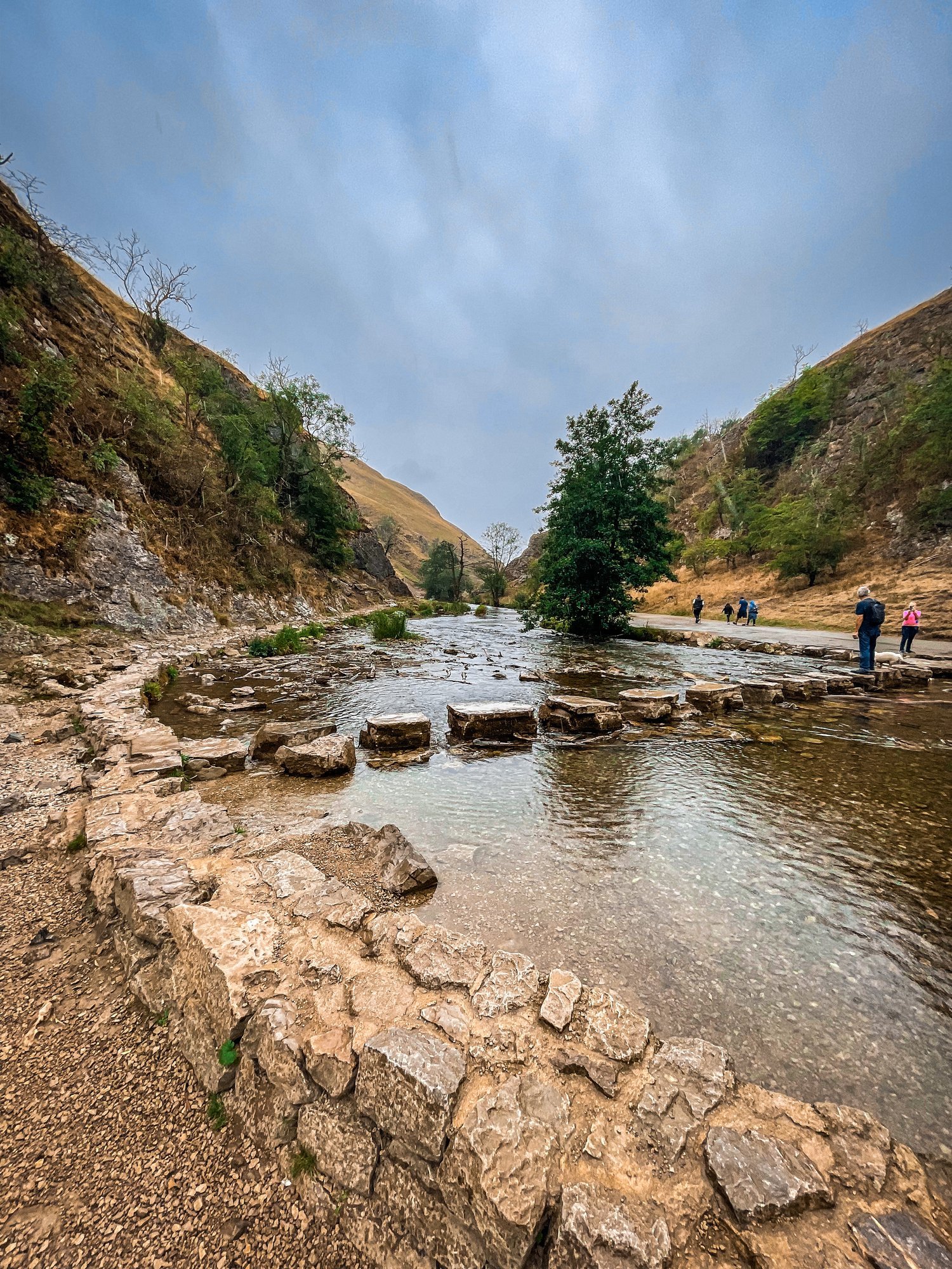
Tucked away beneath the Monsal Trail is the peaceful nature reserve of Chee Dale, where the River Wye meanders through a deep limestone gorge, providing two sets of stepping stones across the river. This route features as one of our Top 10 Walks in the Peak District, and with good reason!
Our Chee Dale Stepping Stones walk starts from Millers Dale Car Park and leads you down into a verdant gorge where you’ll cross two sets of atmospheric stepping stones along the limestone walls, before climbing back up to the Monsal Trail.
This is a slippy route on even the best of weather days, so walking boots definitely required for this one.

While the Dovedale usually takes the Peak District steppingstone limelight, lesser-known Chee Dale makes for a great off-road adventure if you want to beat the crowds.
The stepping stones and surrounding nature reserve – which lie beneath an overhanging cliff of limestone along the River Wye – are truly a must-visit Peak District attraction. So much so, this was our fourth (and certainly not last) visit…
About Chee Dale | Route Good-to-Knows
Made up of a 200ft deep limestone gorge, Chee Dale is filled with woodland, an abundance of wildlife, with the River Wye meandering through.
This walk is a 5mile circular route, first taking you through Chee Dale and along the famous stepping stones, before heading back up to the Monsal Trail and finally making your ascent through the nearby fields, with marvellous views down into the valley.
Miller’s Dale Carpark costs: £5 for the day
If the carpark is full, you can find alternative parking at a large layby just off the A6, on the west side of Chee Dale which offers free parking (Search ‘Chee Dale Layby’ on Google maps).
Public Transport: Make your way to Buxton (either via train or bus), then hop on the number 65 bus, which goes through Miller’s Dale between Tideswell, Linton and Buxton.
Facilities: You’ll find toilets and cafe at Miller’s Dale. Towards the end of the walk at Beech Croft Farm, you will also find Daisies coffee shop.

Fancy giving this one a go? Follow our route here
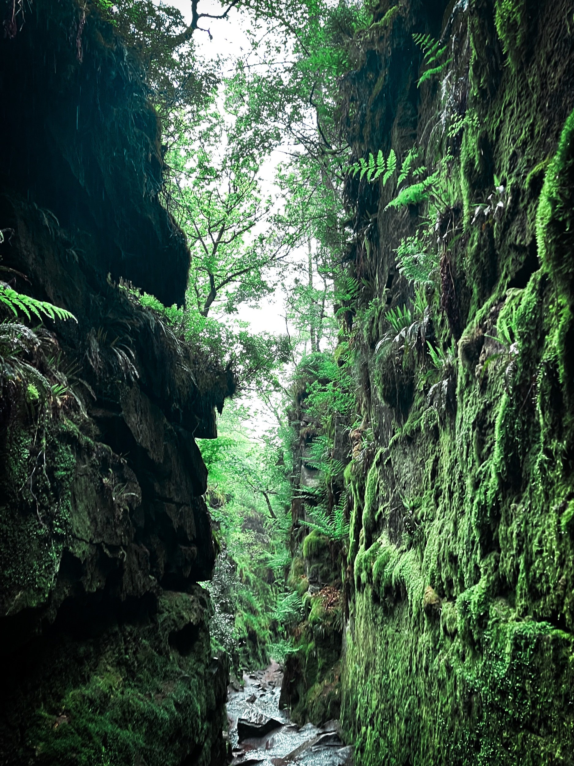
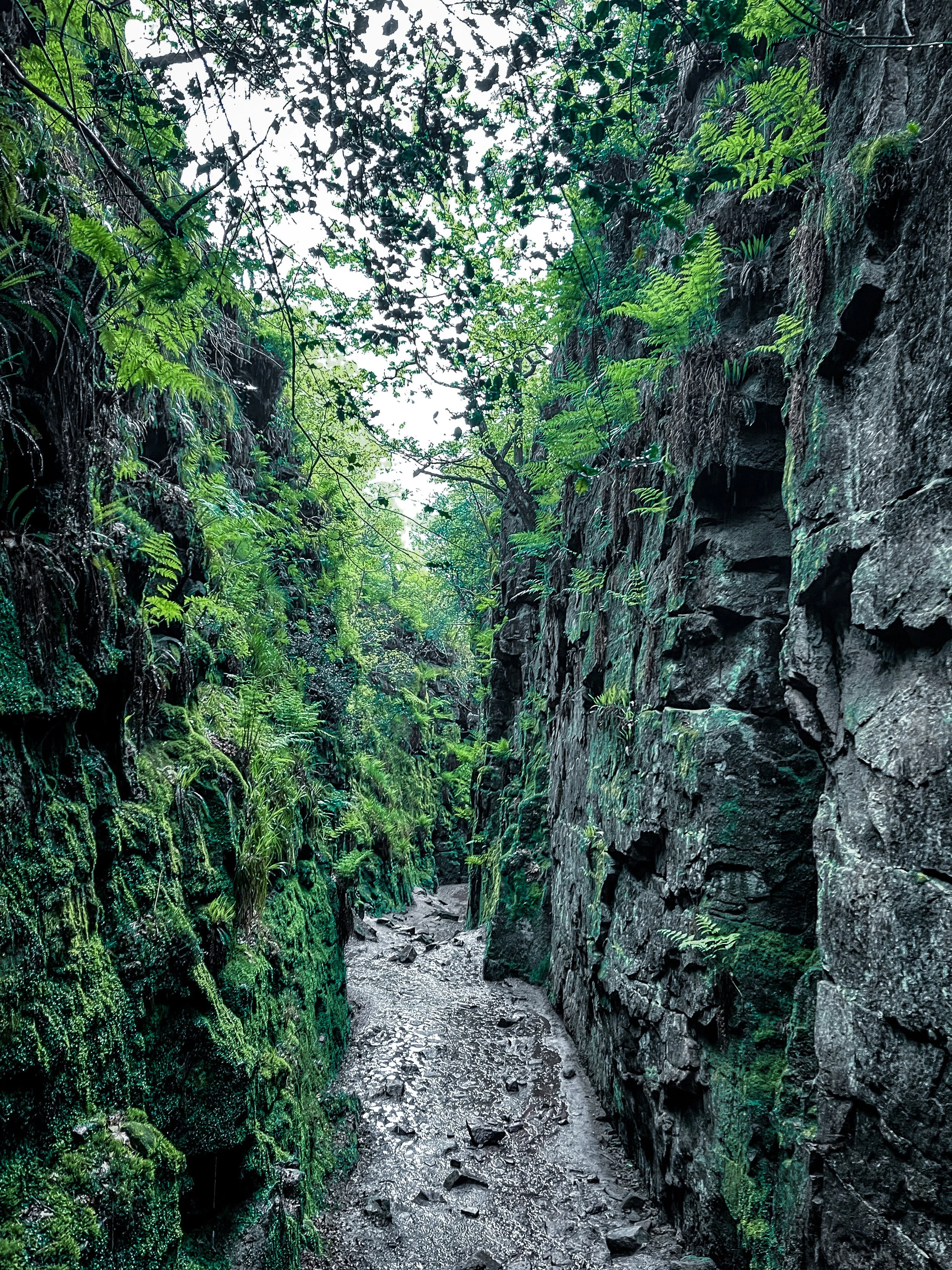
LUD’S CHURCH VIA THREE SHIRE HEADS WALK
Always fancied venturing to Lud’s Church? Why not tick off two Wonders of the Peak in one day with a visit to Three Shires Head and go for a dip while you’re at it?

Start: Gradbach Car Park, SK17 0SU
Distance: 6.65 miles
Duration: 2-3 hours
Elevation: 900 feet
Navigation: follow our route here

Three Shires Head is where the counties of Derbyshire, Cheshire and Staffordshire meet at a waterfall and collection of pools on the River Dane. It’s a stunning spot, and perfect if you love a wild dip! Even on a cloudy day, it’s a firm favourite Peak District wild swimming location — making the ideal base for a picnic and paddle.

Lud’s Church itself is one the Peak District’s must-see landmarks, and from the moment you step foot into its surrounds, we’re sure you’ll understand why. Pictures definitely don’t do this place justice, so a trip to Lud’s is a must!

The ravine that makes up Lud’s Church is thought to have formed during the post-glacial period —some 11,000 years ago— by a large slip of Roaches Grit: a coarse form of sandstone.
It wasn’t until the 15th century that this place became a popular place to dwell— among a secret community, at least. A group of religious dissenters called the Lollards flocked here to hold covert religious meetings to escape the prosecution of the Catholic Church. It’s thought the name of a man arrested at one of these meetings, Walter de Ludank, inspired the name of the site.

Today, the area provides a dramatic nature walk through the Black Forest, transporting passers-by into old England and its many forgotten tales. You certainly don’t have to stretch your imagination too much to picture this place as the origin of many myths and mysteries.
Over the centuries, its’s been associated with tales of Robin Hood and his Merry Men, who’re thought to have hid here as a place of refuge.

Our route starts in Gradbach, first taking you up a forgiving ascent up to Three Shires Head. Once here, make the most of the opportunity for a pitstop — whether you fancy a wild dip or a quick refuel. From here, we return along the River Dane back towards Gradbach, where you can stop off at The Cafe at Gradbach. The cafe sells everything from sweet treats and coffees, to even a prosecco and a pint! Can’t find a better pitstop around, if you ask us.
From the cafe, we begin a short climb up to, what some may deem, the main event: Lud’s Church. This mystical chasm is shrouded in history and myth at every turn — we’ve visited a handful of times and it never fails to take our breath away!

With such a variety of landscapes in a relatively short walk, this is definitely one of our favourite walks in the North West. It’s a cracking walk and takes in multiple picturesque parts of this beautiful area. And if you fancy making a proper day of it, why not take a trip to The Roaches following our extended route here?
Fancy following along? Find step-by-step navigation here
GOYT DAM
Panoramic views, magical woodlands and peaceful picnic spots are just some of the reasons you’ll want to head to Goyt Valley
Start: Whaley Bridge, SK23 7LX
Distance: 7.71 miles
Elevation: 1,075 feet
Duration: 2-3 hours
Navigation: follow the route here
This relaxed Peak District walk is beautiful in any season, but the way the woods are painted with gorgeous auburn hues come late September should make this route appear high on your list of autumn woodland walks.
Lying just a few miles northwest of Buxton, The Goyt Valley is magical place — one that’s gained popularity from visitors since Victorian times.
Once a prosperous and industrious community, the signs of a time gone by are all but extinct, bar from the ruins of Errwood Hall. Back in 1937, the construction of Fernilee Reservoir completely changed this beauty spot’s landscape, but the area remains a wonderfully peaceful place to visit to this day.

Expect stunning views every way you turn, thanks to a unique landscape which was carved out by successive Ice Ages and the River Goyt. It’s the perfect location for a day of recharging your batteries, with the natural scenery and rolling hills surrounding making for a wonderfully soothing trip outdoors.
With free parking at many of the valley’s landmarks, enjoying a day’s stroll around Goyt Valley is easy — especially if you follow one of the waymarked routes starting from Errwood Car Park.
For us, though, the beauty of this trail starts not in the valley, but in nearby Whaley Bridge. Along the way, expect dense pinewoods and azalea bushes, ruins of worker cottages and even a shrine close to the ruins of an abandoned hall.

And if folklore is more your thing, local legend has it that a highwayman called Pym used to lay in wait to ambush those who used the old packhorse route, hence the name Pym Chair given to one of the peaks in this mesmerising landscape.
Fancy giving this one a go? Follow the route here

PLAGUE VILLAGE LOOP
Eyam: the quaint Peak District village known to visitors and residents alike as the ‘Plague Village’. Take a trip though its fascinating and inspiring history…

Start: Eyam Hall, Hope Valley, S32 5QW
Distance: 5.35 miles
Duration: 2.5 hours
Elevation: 725 feet
Navigation: follow the route here

Most hikers are drawn to Eyam for its famous landmarks nearby, from Padley Gorge and Curbar Edge, to Sir William Hill and Eyam Moor.
But for us? To miss the atmospheric beauty of this village and its fascinating history would be a tale as sorry as Eyam’s past. Because a trip round this setting is to take a step back in time — where you can immerse yourself in the incredible story of Eyam’s unselfish villagers who sealed themselves off from the outside world to prevent the deadly disease from spreading.

Today, in a post-pandemic world, it’s even more poignant than it once was — a story we can all relate to, albeit under slightly less extreme and tragic circumstances.
First concentrated in London, the plague began to spread in 1665, with the authorities doing little to stop the spread. As the rich, including King Charles II, fled the capital to their country estates, the poor were left to face a merciless fate. Instead of providing relief measures and aid, the House of Lords decided that the policy of ‘shutting up’ infected individuals within their household would apply to all, except persons of note. Sound familiar?

The Plague was brought to this Peak District village via package in 1665, a package containing infected cloth from London. As you walk around the village, you can trace the package’s initial movements, from the Church of St Lawrence, to the Plague Cottages, the Riley Graves, and beyond.
Due to the unique actions taken by its villagers, Eyam’s people became known heroically, thanks to their actions taken to stop the spread of disease. As Eyam wasn’t able to support itself while in quarantine, you can see remains of their survival to this day.
Mompesson’s well, found today on the village boundary, was used to exchange money for food and medicine. To pay for these supplies, villagers left money in water troughs that were filled with vinegar — a substance thought back then to ward off and kill disease.

While these measures undoubtedly saved the lives of thousands in the surrounding area, Eyam became so known during the plague due to the high price they had to pay. Percentage wise, the village suffered a death toll greater than that of London.

Our route takes you past the church of St Lawrence, which dates back to Saxon times and still has its original font and Normal pillars. In the churchyard you’ll find an eighth-century Celtic Cross, decorated with a mixture of Christian and pagan symbols signifying life from a time gone-by.

Expect wells, water, plague and pilgrimage aplenty as you follow our gentle hike through Eyam and onto Stoney Middleton, wandering along old paths and tracks between two picturesque Peak District villages.

History lovers: this is one of the best hikes the Peak District has to offer. Fancy giving it a go? Follow the route here

WINNATS PASS AND ODIN MINE WALK
One of the best Peak District walks just a short drive from Manchester

Start: Castleton Visitor Centre, S33 8WN
Distance: 5.02 miles
Elevation: 900 feet
Duration: allow approx. 2 hours
Navigation: follow the route here

This walk takes you high above Winnats Pass and around Castleton, meaning you can take in this amazing Peak District village from all angles. The start of the route leans towards the challenging side, taking you up a steep and rocky path straight up to Winnats Pass, so consider if this one’s for you before heading out.

The first ascent is steep with scrambling required. Thankfully, a kind soul has left a climbers rope tied to a gate post which gives you all the leverage you need. We’ve been meaning to give this one a go for a while, and it didn’t disappoint.
The route starts near Castleton Visitor Centre where you’ll find a shop, cafe and toilets… among a gorgeous array of nearby pubs, eateries and cafes.
The car park is pay and display, but there’s street parking available nearby (be aware these fill up quickly during peak hours, so we recommend getting down early).

Once atop Winnats Pass, you’ll follow a trail that leads close to the boundary wall and takes you along the top of the pass. Be sure to stop and take in the views on this part of the walk, we were blown away watching the tiny cars winding their way through the Way.
From here, you’ll head along a footpath in the direction of Mam Tor, before taking a detour to Odin Mine: a disused mine thought to be in use since around 1260. The landscape surrounding makes for great exploring, leading you to the collapsed road constructed beneath Mam Tor.

Once you reach Treak Cliff Cavern, look out for signs that tell you about the history of the area. Winnats Pass and the surrounding environment was once under a tropical sea, making the site protected by law due to the many fossils of sea creatures which lived here over 350 million years ago.
The valley was created by melting glaciers which gradually dissolved, creating streams which flowed through and under cracks in the rock. One of these streams created a large underground cave system which eventually collapsed, leaving Winnats Pass you see today!

With so much to see in such a short walk, this is undoubtedly one of our favourite walks when visiting Derbyshire.
Fancy giving it a go? Follow the walk here

GIDDY EDGE WALK
Walk on the wild side along Matlock’s ‘Giddy Egde’

Take on a whirlwind adventure through the heart-stopping heights of Giddy Edge on High Tor in Matlock, while also indulging in the romance of Lover's Walk in Matlock Bath. Prepare to have your adrenaline pumping and your heartstrings tugged as we explore these two enchanting highlights in one route.

Start: Matlock Town Centre, DE4
Distance: 5.41 miles
Duration: 2.5 hours
Elevation: 1,175 feet
Navigation: follow the route here

Giddy Edge, High Tor

Giddy Edge… the name alone sends shivers down your spine! This exhilarating path is not for the faint of heart, but for the adventurous souls seeking an adrenaline rush — this one’s for you. As you walk along the narrow cliff edge, take in the awe-inspiring panoramic views of the Derbyshire Dales and don't forget to capture those Instagram-worthy moments!
Along the way, keep an eye out for the famed rock formations, including the legendary "Cromford Tooth." Rumor has it that touching it brings good luck, but be cautious, for superstitions and precipices don't always mix well!
Lover's Walk, Matlock Bath

Now that you've conquered Giddy Edge, it's time to shift gears and embrace the romantic ambiance of Lover's Walk in Matlock Bath. This picturesque riverside path, flanked by lush greenery, is perfect for lovebirds or anyone seeking a moment of tranquility. The charming Victorian-style lampposts transport you back in time… but if you’re after a post hike snack, the nearby Greggs should bring you back to 2023 in no time.
Attractions not to miss during your visit:
Heights of Abraham
After your adrenaline-fuelled adventure along Giddy Edge, make your way to the Heights of Abraham. This unique hilltop park offers cable car rides that will sweep you up into the clouds, providing breathtaking views of the surrounding countryside. It's a perfect opportunity to catch your breath and marvel at the beauty of Matlock below.
Matlock Bath Aquarium
For those fascinated by marine life, a visit to the Matlock Bath Aquarium is a must. Immerse yourself in the captivating world beneath the waves and explore an array of exotic species. From vibrant tropical fish to mesmerizing jellyfish, this aquatic adventure will leave you in awe.
The Fishpond Pub
Walking can make even the hardiest adventurer thirsty, so be sure to stop by The Fishpond Pub. Nestled in the heart of Matlock Bath, this charming establishment serves up a delightful selection of local ales, craft beers, and refreshing beverages. Unwind in their cosy beer garden or warm up by the crackling fireplace on colder days. Cheers to a well-deserved break!

Ready to brave Giddy Egde? Follow the route here

8 BEST WALKS IN THE PEAK DISTRICT
Looking for the BEST walks in the Peak District? Look no further…
The Peak District attracts thousands of tourists each year to its many peaks… and with good reason! Aside from its stunning natural beauty, picturesque landscapes, and endless opportunities for exploration, The Peak District has a charm that many other national parks don’t… with many a quaint northern village to visit along your way.
Luckily for us, this magical place is right on our doorstep — and is certainly high up our list when it comes to planning a hike not too far from Manchester. New to the Peak District? If you’re yet to explore the magnificent trails right on our doorstep, you might as well start with the best first, eh?
To help you on your way, we’ve compiled a list of the BEST 8 walks in the Peak District — they won’t disappoint.
Mam Tor, Edale

Mam Tor is a classic walk in the Peak District, and for good reason! It offers stunning views across the Edale Valley, and is a relatively easy climb for beginners. The trail is well-marked and takes you through the famous Winnats Pass, a narrow limestone gorge. Don’t forget to snap some pictures at the summit and enjoy the panoramic views of the surrounding hills and valleys!
Start: Peak Cavern, Castleton
Distance: 7.41 miles
Duration: 3-4 hours
Ascent: 1,700 feet
Navigation: follow our trail step-by-step here.
2. Kinder Scout, Hayfield
Kinder Scout is the highest peak in the Peak District, and a popular spot for hikers. The walk can be challenging, but the views are worth it! You’ll pass through wild moorland and take in views of the surrounding peaks. If you’re lucky, you may even spot some wildlife along the way. Keep an eye out for mountain hares, red grouse, and even peregrine falcons!
Distance: 8.15 miles
Duration: allow approx. 3-4 hours
Elevation: 1,500 feet
Start: Bowden Bridge Car Park, SK22 2LH
Navigation: follow our route here.
3. Bamford Edge, Hope Valley

Bamford Edge is a stunning ridge walk that offers some of the best views in the Peak District. This is a real treat of a walk, offering some of the best views in the Peak District. With just a short climb at the start, you walk towards Bamford Edge and are instantly rewarded with incredible views of Ladybower and Derwent Reservoirs. Up top, you’ll also find another great vantage point in the form of Win Hill. The easygoing nature of this route makes it a popular location for sunrise and sunset.
Distance: 3.53 miles
Elevation: 650 feet
Duration: 1.5 hours
Start: Heatherdene Car Park, S33 0BY
Navigation: follow the route here.
4. Thor’s Cave, Wetton

This is a brilliant route that takes in some of the best landmarks the Peak District has to offer: the beauty of Manifold Valley and the magnificence of Thor’s Cave. Just look at those views!
Thor’s Cave is an iconic natural cavern on the side of the Manifold Valley, making it a perfect spot to reward your efforts after a long day’s walk. Some scrambling to the chamber is required, making it perfect for big kids and little ones alike. There are some steep uphill segments but the views are worth it. The views out into the valley are immense, but do make sure to take care while exploring there are steep drops shortly after the entrance and the surface can be slippery.
Start: Wetton Mill, DE6 2AG
Distance: 7.74 miles
Duration: allow 3-4 hours
Elevation: 1,350 feet
Navigation: follow our route here
5. Padley Gorge and Stanage Edge, Hathersage

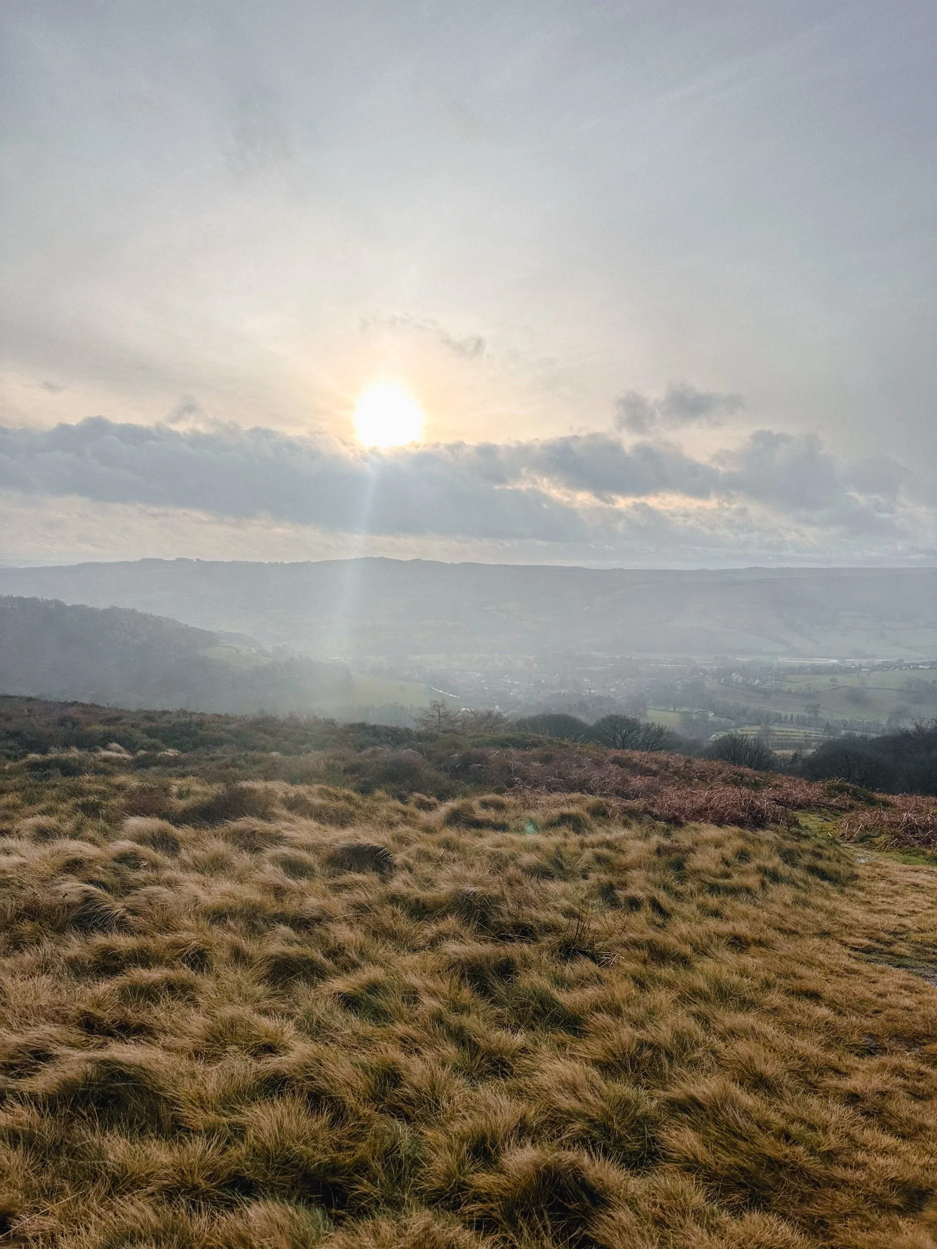
Stanage Edge is a popular spot for rock climbers, but it’s also a fantastic walk with stunning views. The trail takes you along the edge of a gritstone escarpment, where you can see views of the Hope Valley and the Dark Peak. Keep an eye out for the resident mountain goats, and take some time to appreciate the natural beauty of the Peak District.
Our favourite circular walk takes in less-populated trails from the busy Stanage Edge routes around Hathersage, with equally impressive views. Starting at Upper Burbage Bridge Car Park just outside of the town centre, this trail takes you to the magical Padley Gorge, before meandering back for a short scramble up Carl Wark — an awe-inspiring rocky tor.
Start: Upper Burbage Bridge Car Park, Hope Valley, S32 1BR
Distance: 5.3 miles
Elevation: 650 feet
Duration: allow approx. 2 hours
Navigation: follow step-by-step
6. Thorpe Cloud, Dovedale
Dovedale is a beautiful valley walk that takes you along the River Dove. The trail is relatively flat and easy-going, making it a great option for families or those looking for a more relaxed hike. The valley is home to a variety of wildlife, including kingfishers and otters. Take some time to appreciate the stunning rock formations, such as Thorpe Cloud and the famous stepping stones!
Thorpe Cloud is a gorgeous limestone hill that attracts thousands of visitors each year thanks to its unique shape. The route up to the summit is easy-to-follow, navigated by blue markers on signposts. With some steep parts that’re a good challenge for beginners, the walk is short and sweet with plenty of options to extend if you’re feeling particularly energetic.
Start: Blore Pastures Carpark, DE6 2BS
Distance: 5.49 miles
Duration: 2.5 hours
Elevation: 1,000 feet
Navigation: follow the route here
7. B52 Crash Site
By no means the easiest walk but defintiely a firm favourite amongst locals, the climb up to Higher Shelf Stones and the Over-Exposed crash site is definitely one of the most rewarding ones close to Manchester.
Starting from Glossop makes for a longer ascent — but if you’re looking to shorten the route, parking on Snake Pass near to the Pennine Way entrance gives you the best of both worlds: a shorter trail with the same amount of rewards.
Unlike a lot of the more strenuous hikes where the best views lie way up top, this route offers you insane views with every step you take.
Along the way, you’ll escape the confines of the valleys in favour of the sanctuary of high moors. The streams you see along the way make for a great respite on a sunny day — but it can get quite boggy so walking boots are a must on this one.
Start: Manor Park, Glossop
Distance: 9.24 miles
Duration: 3-4 hours
Ascent: 1,600 feet
Navigation: follow the route step-by-step here
8. Snake Woodlands

Easily missable as you drive along Snake’s Pass (A57), this magical wonderland is hidden from view until you venture down into the woodland adjacent. This stunning pine forest landscape will have you feeling like you’re in the depths of a Canadian national park, much less on the outskirts of Glossop…
Surrounded by rolling hills, pine trees and babbling streams, you won’t be short on fairytale-like scenery on this short circular walk. In fact, this route has a mix of everything: magical woodlands, eerie moorland and even some spooky ruins to boot.
This route in itself is an absolute gem — but if you’re looking to get a few extra miles in, popular Peak District landmarks Higher Shelf Stones and the B52 Crash Site can easily be incorporated.
Start: Hope Woodland Car Park, S33 0AB
Distance: 3.59 miles
Duration: 1-2 hours
Elevation: 400 feet
Navigation: follow the route here.

BEST WALKS IN THE PEAK DISTRICT: TOPLEY PIKE
Discover the beauty of the Peak District: Harpur Hill to Blue Lagoon

Start: Harpur Hill, SK17 9LD
Distance: 7.11 miles
Duration: 2-3 hours
Elevation: 475 feet
Navigation: follow the route here

If you're looking for a fun and adventurous way to explore the best walks near Manchester, look no further than Topley Pike Nature Reserve: home of rolling hills, all-to-yourself valleys and stunning surrounds every way you turn.
It’s one of the less busy routes you’ll find in the Peak District, making it the perfect base to escape the hustle and bustle of everyday life and immerse yourself in the tranquility of the great outdoors.

Starting from Harpur Hill, this small village in Buxton is the ideal place to begin a leisurely stroll up to Topley Pike. From here, you'll set out on a winding path that will take us towards Topley Pike Nature Reserve. Please note, the outward trip to Topley Pike is via an unpaved a-road, so please take care during this section of the route.
Once you’ve made it to the boundary, you'll be rewarded with stunning views of the Thirst House Cave, a true wonder of the Peak and a must-visit for any outdoor enthusiast.
After admiring the tranquility of Thirst House Cave (you’ll struggle to see another soul along the way!), continue on to Deep Dale, a peaceful valley surrounded by rolling hills and lush vegetation. This idyllic spot is perfect for a picnic or a quiet moment to take in the serenity of the area. AWith narrow, winding paths and wildlife darting amongst the trees, this section of the route is a true feast for the senses.
Now to head back to the starting point for the main event: Buxton’s infamous ‘Blue Lagoon’.
With its striking blue colour and picturesque white shores, Harpur Hill Quarry in the Peak District is the perfect example of a dangerous beauty. The pool is no hidden gem — thousands of people visit the site each summer, which is why we much prefer a visit during winter. Plus, there’s no danger of anybody jumping in during this season… which, trust us, is something nobody wants to do.

Its vivid colour is actually a result of freezing cold rainwater mixing with minerals discarded from decades of the industrial burning off of quicklime. The toxic mix of chemicals in the water have the same pH value as bleach, which could cause anything from skin irritation to severe sickness.
Interested to know more? Scroll down to read more about the History of Blue Lagoon.

Whether you’re interested in the history or just here for the views, lease do take care and observe the ‘no swimming’ signage. This is no dipping spot!
Despite its dangers, Blue Lagoon remains one of the most popular destinations in the Peak District — and after another trip up in winter without the crowds, we can certainly see why.

Still here, are ye?
Get out there and explore the best walks near Manchester, here.
The History of ‘Blue Lagoon’, Buxton

Harpur Hill, officially known as Hoffman Quarry, has a very long and rich history producing quicklime, with small-scale lime burning beginning in the 1600s, before large-scale quicklime production was carried out beside the quarry from 1835 to roughly 1952. The bigger production demands meant using larger shaft kilns, which led to the use of a multi-chambered Hoffmann kiln, operated by Buxton Lime Firms Ltd.
During the Second World War, the quarry was used by the RAF as a depot to store chemical weapons – the biggest such site in the country at some 500 acres. Later, Harpur Hill was deemed a good place to dispose of captured German chemical munitions. The surrounding hills were used to burn such weapons as phosgene and mustard gas with bleach, sending plumes of acrid smoke into the air. The depot shut in 1960 with the area remaining vacant ever since. Incidentally, the site was also home to an RAF Mountain Rescue team who would respond to air crashes the length and breadth of Derbyshire.
In 1980, the Hoffmann lime kiln was demolished in an effort to create space for an industrial estate. Massive volumes of solid waste left over from the lime burning were dumped in nearby tips, thus creating spoil heaps contaminated with traces of quicklime plus ash from the coal used in the process.
The aforementioned rainwater filtering through the waste leaches calcium hydroxide and in turn becomes heavily alkaline. Signs dotted around the site clearly say the water can cause "skin and eye irritations, stomach problems and fungal infections such as thrush" and that the quarry is known to contain all manner of things you definitely don’t want to go swimming with – including dead animals, excrement, car wrecks, and piles of rubbish.
Despite its inviting Mediterranean hue, the water is extremely cold. Yet many seem to still view the area as a popular tourist destination, causing much frustration for nearby residents.

THORPE CLOUD
Gothic manors… idyllic tearooms… and a trig point to boot — this walk in Ashbourne has it all

Start: Blore Pastures Carpark, DE6 2BS
Distance: 5.49 miles
Duration: 2.5 hours
Elevation: 1,000 feet
Navigation: follow the route here

Whether you’re here for the stepping stones across the River Manifold, or fancy indulging in the history of this quaint town’s old manor house, a day trip to Ilam Park is always a good idea.
After a meander around Ilam Hall, our route takes you up Thorpe Cloud as you summit the hill for breathtaking views across the dale, and return home via the stepping stones across the River Dove.

Thorpe Cloud is found in the White Peaks on the southern end of Dovedale — a gorgeous limestone hill that attracts thousands of visitors each year thanks to its unique shape and close proximity to Dovedale Stepping Stones.
The route up to the summit is easy-to-follow, navigated by blue markers on signposts. With some steep parts that’re a good challenge for beginners, the walk is short and sweet with plenty of options to extend if you’re feeling particularly energetic.
The Stepping Stones are a very popular Peak District attraction, so if you’re wanting to explore free from pedestrian traffic, we’d definitely recommend visiting off-peak if that’s an option for you.
That said, they’re a must-do Peak activity… and well worth the visit!

Grab yer hiking boots and follow one of our favourite Peak District walks here

LANTERN PIKE
A stunning stroll around Hayfield’s lesser populated countryside

Start: Sett Valley Trail Car Park, SK22 2JG
Distance: 7.63 miles
Elevation: 1,150 feet
Duration: 3.5 hours
Navigation: follow the route here

If you’re an avid hiker, we’re sure you’re no stranger to the Peak District ‘big one’, Kinder Scout. But have you ever traversed this village’s lesser known trails?
Starting on the Sett Valley Trail. this walk leads you up to the fallen trig point at Lantern Pike, finishing off at one of our favourite country pubs this side of the Pennines, The Little Mill.

As far as trig point routes go, this is a scenic one for sure. The start of the walk takes you along Birch Vale Reservoir along a tree-lined path that’s a haven for wildlife.
From here, you journey onwards to a short climb up towards the Pennine Bridleway where the lane narrows into a stony path just before the base of Lantern Pike. Once you’ve reached this point, it’s smooth sailing up to the rig point atop the summit.
And as for the views when you’ve reached the trig? You’ll instantly forget about the slog up to the summit — rewarded with insane, far-reaching views as far as the eye can see. Expect a patchwork of fields, heather moorland and the magnificence of towering neighbour, Kinder Scout.

Don’t fancy giving the trig challenge? Fear not, The Sett Valley Trail itself makes for an incredible Sunday Stroll with 2.5 miles of traffic-free scenery perfect for walkers and cyclists alike.
The trail follows a former railway line through the beauty of Derbyshire’s countryside, taking you along the Pennine Bridleway between Hayfield and Birch Vale.

And if you’re after ticking off a few trigs in one day, why not extend the walk to include nearby Harry Hut and Burnt Hill?
Or if you fancy following our shorter route, give it a go here!

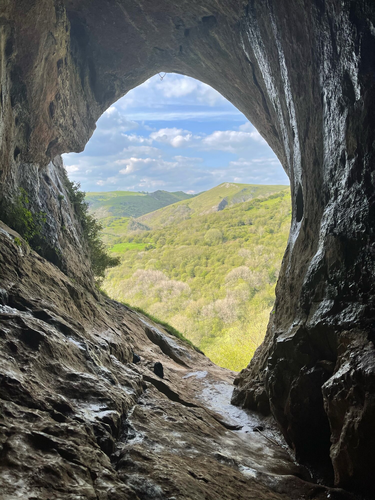
THOR’S CAVE
Thor’s Cave is known as one of the Peak District’s most famous caves… and with good reason.

Start: Wetton Mill, DE6 2AG
Distance: 7.74 miles
Duration: allow 3-4 hours
Elevation: 1,350 feet
Navigation: follow our route here

This is a brilliant route that takes in some of the best landmarks the Peak District has to offer: the beauty of Manifold Valley and the magnificence of Thor’s Cave. Just look at those views!

From Wetton village, this route first takes you along the Manifold Valley and past Wetton Mill with more caves to explore, before allowing you to finish at the perfect beauty spot: Thor’s Cave.

Thor’s Cave is an iconic natural cavern on the side of the Manifold Valley, making it a perfect spot to reward your efforts after a long day’s walk. Some scrambling to the chamber is required, making it perfect for big kids and little ones alike.

Thor’s Cave is a popular attraction so we recommend visiting out of season or towards the end of day to avoid a wait up to the cave. You can also shorten the walk—and fast-track your arrival on busy days— by simply heading to Thor’s Cave and back from Wetton, cutting out the meander along the Manifold Valley.

There are some steep uphill segments but the views are worth it. The views out into the valley are immense, but do make sure to take care while exploring there are steep drops shortly after the entrance and the surface can be slippery.

The origin of Thor’s Cave name is unknown but has obvious links to the Norse god Thor. Historically, evidence of human occupation of Thor’s Cave has been found dating back to the latter part of the Stone Age, around 11,000 years ago—with continued use into the Iron Age and Roman period. Excavations of the area have found living utensils such as stone tools, pottery and bronze items, as well as burial sites for seven people.

Fancy giving it a go? Follow our route here

PADLEY GORGE
Gently flowing waterfalls… easy-going ascents… impeccable views and a pub pit-stop, Padley Gorge loop is one of the Peak District’s best circular walks

Start: Upper Burbage Bridge Car Park, Hope Valley, S32 1BR
Distance: 5.3 miles
Elevation: 650 feet
Duration: allow approx. 2 hours
Navigation: follow step-by-step

Route Overview:
This circular walk takes in less-populated trails from the busy Stanage Edge routes around Hathersage, with equally impressive views. Starting at Upper Burbage Bridge Car Park just outside of the town centre, this trail takes you to the magical Padley Gorge, before meandering back for a short scramble up Carl Wark — an awe-inspiring rocky tor.

Higger Tor, Hathersage Moor, Carl Wark and Burbage Edge are all included in this loop. Starting at the free car park at Burbage Bridge, you’ll be hard-pressed to see another soul for the first half of the walk, as you walk along side a stream and through the forest away from the more popular trails.

Be prepared for a slight scramble as you reach the tops of Higger Tor and Carl Wark. The approach from Burbage Bridge can also get a little boggy, so make sure to grab your waterproof boots before attempting this one.

Why not extend your walk with a visit to Little John’s grave? As you head towards Hathersage, you can expect magical panoramic views of faraway landmarks, moors and meadows.
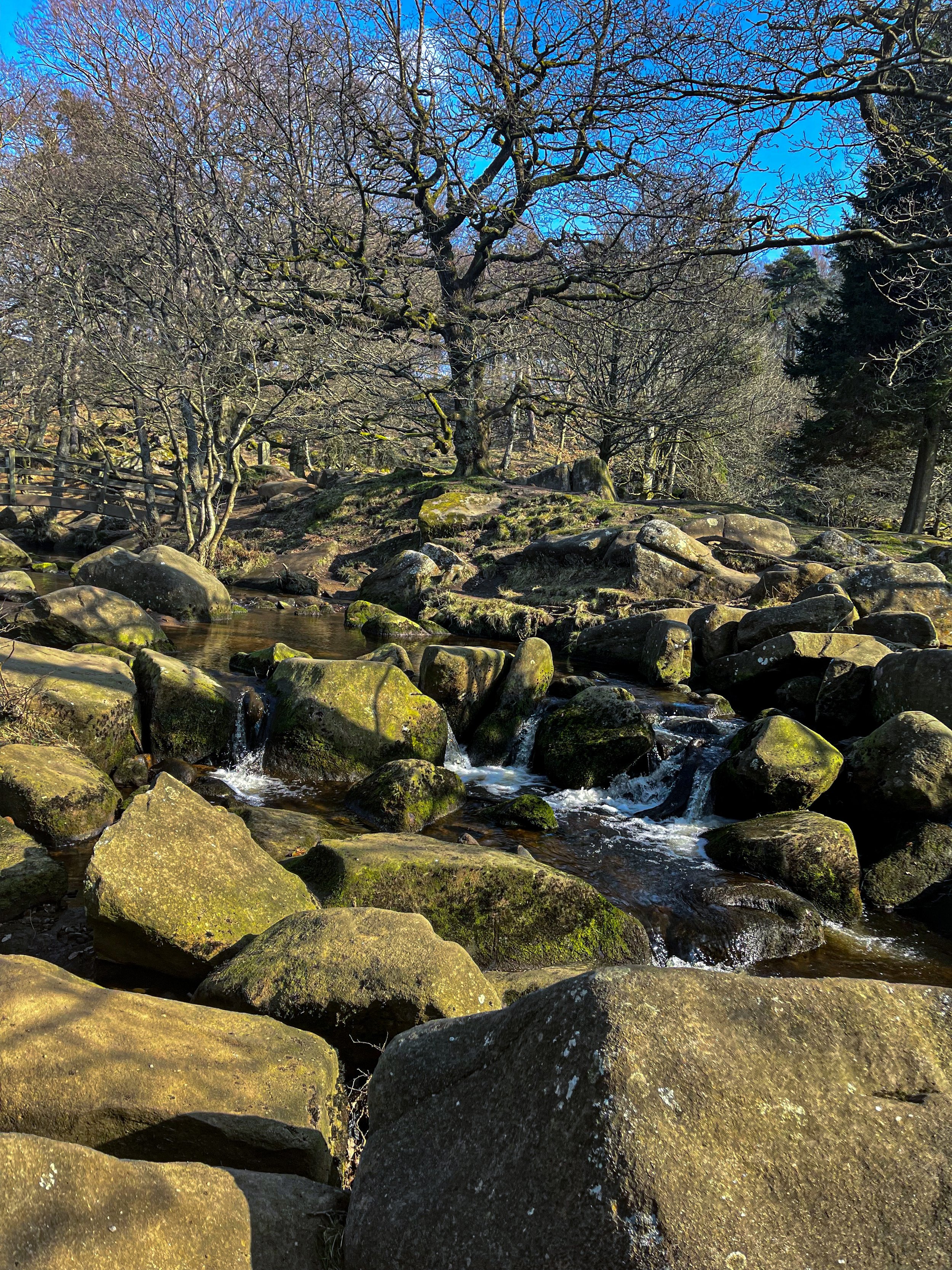
Follow our route step-by-step here - happy exploring!
UPHILL CHALLENGES:


WALKS WITH WATERFALLS:


