ALL TRAILS

Cwm Prysor Viaduct: an atmospheric walk in Eryri
Don’t miss this hidden gem walk tucked away in the Snowdonia mountains

Start: Lay-by on the A4212, near Llyn Tryweryn (what3words: stack.crouching.scramble)
Distance: 1 mile (to the viaduct and back) or 9 miles out and back to the layby near Trawsfynydd (extended route)
Elevation: 850 feet
Duration: 1-4 hours (depending on your chosen route)
Difficulty: Easy
Navigation: Follow step-by-step on komoot, or download GPX file
About the route
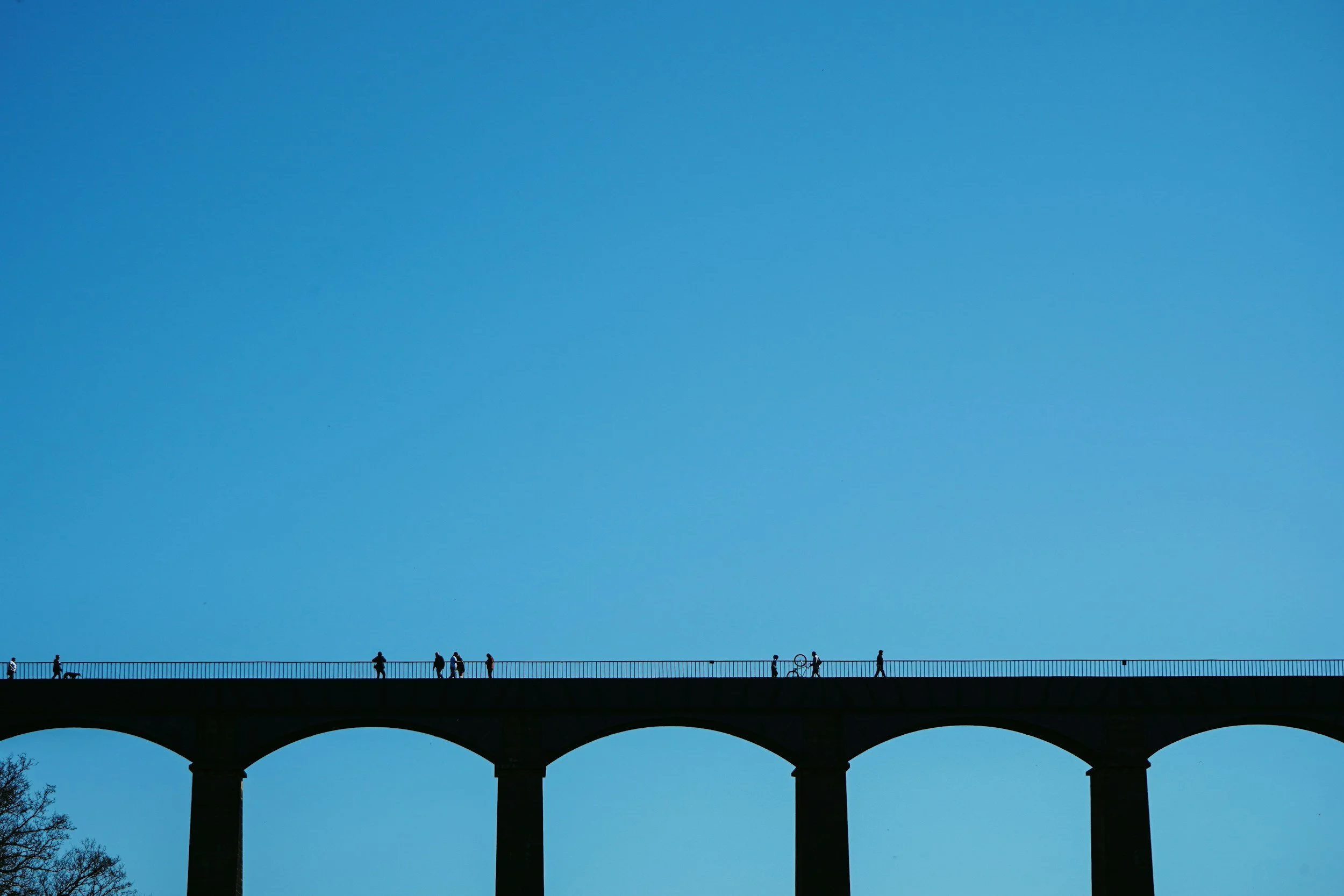
Not far from the A4212 in Eryri (Snowdonia), Cwm Prysor Viaduct spans a lush valley with all the drama of a Highlands rail bridge — and none of the crowds. Built in the 1880s, this nine-arch structure once carried trains between Bala and Blaenau Ffestiniog. Today, it’s part of a scenic walk along a disused railway line where nature has reclaimed the trackbed, giving the trail a wonderfully wild, secluded feel.
If you’ve ever caught a fleeting glimpse of a dramatic rail bridge from the A4212 between Capel Celyn and Trawsfynydd, you’ve probably spotted Cwm Prysor Viaduct — a graceful relic of Victorian engineering. The old Bala and Festiniog Railway once ran through here, and though the trains are long gone, nature has quietly reclaimed the trackbed, turning this into one of Snowdonia’s most atmospheric hidden walks.
You can make this a quick detour or a full linear adventure along the disused line, soaking up views, viaducts, and moody hillsides along the way.
Distance: 1 mile (to the viaduct and back)
Extended route: ~8.8 miles (out-and-back to road near Trawsfynydd)
Time: 1–4 hours depending on route
Start/End Point: Lay-by on A4212 near Llyn Tryweryn
OS Grid Ref: SH 81438 36262
What3words: stack.crouching.scramble
Dog friendly: Yes 🐾
Public transport: None direct — nearest stop is Trawsfynydd

Route difficulty
The trail is relatively flat and easy to follow, but the mud can be a real limiter. Even in dry spells, the railway trackbed holds water like a sponge — so bring sturdy footwear and consider turning back after the viaduct if it’s been raining heavily. That said, the terrain itself is straightforward, and there’s little elevation gain.
Walk type: Easy to Moderate — mostly flat and steady, with no real incline but very boggy in places.
Terrain: Disused railway path, forestry track, and deeply puddled muddy ruts.
Accessibility: Not suitable for wheelchairs or pushchairs — path is uneven and frequently waterlogged.
Dog-friendly: Yes — dogs are welcome on leads, but be aware of sheep along the route and limited visibility in spots.
Why you’ll love this walk
Rarely visited viaduct with huge views
A “path in the sky” reclaimed by nature
Tadpoles, newts, sheep, and solitude
Extendable into a much longer railway hike

Route highlights
From the lay-by to the viaduct
Park in the lay-by just west of Llyn Tryweryn, then hop over the ladder stile to join a forestry road. At the first fork, go left — this is the start of the disused railway. You’ll follow two muddy tyre tracks through a landscape slowly being reclaimed by nature. Tadpoles squirm in puddles, the old cuttings guide your way, and before long, you’ll catch a glimpse of the viaduct.
Cwm Prysor Viaduct
Spanning 450ft across the valley and rising 120ft above the ground, the viaduct is a stunning reminder of the area’s industrial past. Its nine arches feel almost Roman in scale, and the deck (a grass path now) is open for walking thanks to a permissive access agreement. There are spots just before the bridge to view the arches — take care, as the terrain can be uneven.
Beyond the viaduct (optional)
If the conditions are dry and your boots are up for it, continue on. The route hugs the hillside and passes through weathered woodlands and pasture, with panoramic views toward Arenig Mawr. Eventually, the trail meets a single-track road near Trawsfynydd — around 4.4 miles from the start point (one way).
Things to do nearby
Llyn Celyn: Scenic reservoir with a controversial backstory
Arenig Mawr: A quieter Snowdonia summit
Trawsfynydd Lake: Ideal for picnics or extending your walk
Bala: A solid base with cafes and mountain shops

Getting to the starting point
The start is a small lay-by on the A4212. From Capel Celyn, drive west past Llyn Tryweryn and watch for the pull-in on your right. From Trawsfynydd, climb the hill — the lay-by is near the crest. The entrance is a little hidden but marked by a gate and stile.
✔️ Good to knows
This is a permissive path, not a formal right of way
Very limited parking
No signage — use OS Maps or a GPS app
Often muddy — especially beyond the viaduct
Keep dogs under control (lots of sheep)
Public transport won’t get you close
🧭 Following the route
I use komoot and OS Maps for offline navigation. To follow the full walk step-by-step on komoot, simply click this link here or download the GPX file and upload it to your chosen app, such as OS Maps.

Woodland walk with a view: Moel Famau circular
A scenic 2-hour loop in North Wales with peaceful forest trails and wide-open views from the summit

Start: Moel Famau Lower Car Park (CH7 5SH)
Distance: 4.26
Elevation: 850 feet
Duration: >2 hours
Difficulty: Easy-moderate
Navigation: Follow step-by-step on komoot, or download GPX file
About the route
Looking for a short but satisfying walk with forest calm and a big view at the top? This circular route up Moel Famau — the highest hill in the Clwydian Range — is ideal for a half-day outing. Starting from the lower car park, the route gently climbs through a mix of conifer woodland and open hillside before reaching the Jubilee Tower at the summit.
You’ll get cracking views over the Vale of Clwyd and Snowdonia on a clear day, and because it’s a relatively short route, it’s doable even if you’ve only got a couple of hours to spare.
Ideal for: beginner hikers, families, solo walkers, or anyone who just fancies a bit of elevation without a full day commitment.

Route difficulty
Walk type: Easy to Moderate — the incline is steady, with well-maintained paths all the way.
Terrain: Gravel trails, woodland paths, and grassy slopes near the top.
Accessibility: Not suitable for wheelchairs or pushchairs due to the gradient.
Dog-friendly: Yes — dogs are welcome on leads, though be aware of sheep on the upper slopes.
Why you’ll love this walk
🌲 Woodland calm – The initial forest section is quiet, shady, and peaceful — perfect for those who like a bit of forest bathing.
🏔 Big views, low effort – It doesn’t take long to feel like you’re on top of the world. The summit view is surprisingly expansive for such a short walk.
🏰 Historic summit – The Jubilee Tower ruins at the top are a unique feature — originally built to commemorate the Golden Jubilee of George III.
🐾 Great for dogs – Plenty of variety, sniffy woodland, and wide-open space to explore (just keep leads handy around livestock).
📸 Photo spots – The summit is very photogenic, especially with light catching the hills and heather in late afternoon.

Route highlights
Moel Famau Forest Trails
The lower slopes of the walk are tucked into the Moel Famau Country Park, with a network of woodland trails that weave through tall pines. It’s peaceful, well-signed, and great for warming up before the ascent.
Jubilee Tower
The partially ruined tower at the summit is a popular viewpoint — built in 1810 to mark George III’s 50-year reign, but never finished due to lack of funds. Now it’s a scenic perch with panoramic views over North Wales and even out to Liverpool Bay on a clear day.
Panoramic ridge views
From the summit, you’ll get sweeping views of the Clwydian Range, the Dee Estuary, and the peaks of Snowdonia in the distance. It’s especially pretty at golden hour when the hills take on a purpley-gold hue.

Things to do nearby
Loggerheads Country Park – Just a 10-minute drive away, this riverside park offers more woodland walks, limestone cliffs, and a visitor centre with café and loos.
Ruthin – A charming market town with a castle, independent shops, and plenty of places to grab lunch or a coffee post-walk.
Llangollen – Around 30 minutes away, this pretty town on the River Dee makes a great add-on for the day with canal walks, a steam railway, and good pub grub.
Getting to the starting point
By Car
Set your sat nav to Moel Famau Lower Car Park (CH7 5SH). Parking fees apply. The roads up are narrow in places, so take it slow on the final stretch.
By Public Transport
Public transport options are limited. The closest rail stations are Mold and Ruthin, but you’d need a taxi or bike to reach the start point from there.

✔️ Good to knows
Footwear: Walking boots or grippy trainers — the path is mostly solid, but can get slick after rain.
Facilities: Toilets at the car park. Closest cafe facilities can be found at Loggerheads or Mold.
Best time to go: Early mornings or late afternoon for quieter paths and beautiful light.
Map: Moel Famau is part of the Clwydian Range AONB — worth grabbing an OS Explorer 265 if you want to explore more of the area.
🧭 Following the route
I use komoot and OS Maps for offline navigation. To follow the full walk step-by-step on komoot, simply click this link here or download the GPX file and upload it to your chosen app, such as OS Maps.

EXPLORE LLANGOLLEN: CASTELL DINAS BRÂN WALK WITH CANOEING OVER PONTCYSYLLTE AQUEDUCT
Explore the historic ruins of Castell Dinas Brân and enjoy stunning views of Llangollen and the Dee Valley, with an optional adventure over the Pontcysyllte Aqueduct.

Start: Llangollen (Parking available at Market Street Car Park, East Street Car Park, and Pavilion Car Park)
Distance: 4 miles
Elevation: 750 feet
Duration: 1.5 hours
Difficulty: Easy (with some moderate sections)
Navigation: Follow step-by-step on komoot, or download GPX file
About the route
Looking for a scenic walk in North Wales? This 4-mile circular walk from Llangollen offers stunning views of the Dee Valley and the surrounding hills. Starting in the charming town of Llangollen, the route gently climbs for fantastic panoramas before looping back down through tranquil woodland and canalside paths.
Or if you’re looking for a real adventure-packed day, you can nip over to the UNESCO-listed Pontcysyllte Aqueduct. It’s the highest canal aqueduct in the world, and you can walk, canoe or take a boat ride over it. One for the adventure bucket list!

Route difficulty
Difficulty: Easy to moderate (Some steep sections on both the ascent and descent)
Terrain: Well-maintained trails with some uneven ground
Dog-Friendly: Yes, but keep dogs on leads near livestock
Route highlights
Scenic Views Over Dee Valley
Enjoy breathtaking views over the River Dee and the picturesque landscape of the Vale of Llangollen. The ascent offers numerous spots to pause and soak in the scenery.
Castell Dinas Brân
Discover the ruins of Castell Dinas Brân, perched high above Llangollen. This medieval fortress offers a fascinating glimpse into Welsh history and provides spectacular panoramic views. The castle ruins are a perfect spot for a break and some memorable photos.
Pontcysyllte Aqueduct
Why not make a day of it? After completing your walk, head to Trevor Basin for a canoeing adventure over the Pontcysyllte Aqueduct. Often referred to as the ‘Stream in the Sky,’ this World Heritage Site offers a thrilling way to experience the canal from a unique perspective.
Canoeing Hire Options: Various operators offer canoe and kayak rentals from Trevor Basin.
Booking Tip: Pre-booking is recommended, especially during weekends and holidays.
Llangollen Wharf
Back in Llangollen, the historic canal wharf offers horse-drawn boat trips, cafes, and local shops. It’s the perfect place to relax and enjoy some proper post-walk grub.

Where to park?
Market Street Car Park
East Street Car Park
Llangollen Pavilion Car Park (Best for larger vehicles or campervans)
Getting to the starting point
By Car: Llangollen is around 1 hour from Chester and 1.5 hours from Manchester.
By Public Transport: Trains to Ruabon, followed by a short bus or taxi ride.

✔️ Good to knows
Best time to visit: The route is beautiful year-round, but early mornings or late afternoons offer the most serene views.
Footwear: Comfortable walking shoes or boots recommended.
Photography tip: Capture the best views from the top of the climb, overlooking the river and town.
🧭 Following the route
I use komoot and OS Maps for offline navigation. To follow the flatter walk step-by-step on komoot, simply click this link here or download the GPX file and upload it to your chosen app, such as OS Maps.
UPHILL CHALLENGES:


WALKS WITH WATERFALLS:


