WINNATS PASS AND ODIN MINE WALK
A hidden gem of a walk taking in some of the best views across the Peak District
Start: Castleton Visitor Centre, S33 8WN
Distance: 5.02 miles
Elevation: 900 feet
Duration: 2 hours
Difficulty: Moderate
Navigation: Follow step-by-step on komoot, or download GPX file
About the route
This walk takes you high above Winnats Pass and around Castleton, meaning you can take in this amazing Peak District village from all angles. The start of the route leans towards the challenging side, taking you up a steep and rocky path straight up to Winnats Pass, so consider if this one’s for you before heading out. The first ascent is steep with scrambling required. Thankfully, a kind soul has left a climbers rope tied to a gate post which gives you all the leverage you need. We’ve been meaning to give this one a go for a while, and it didn’t disappoint.
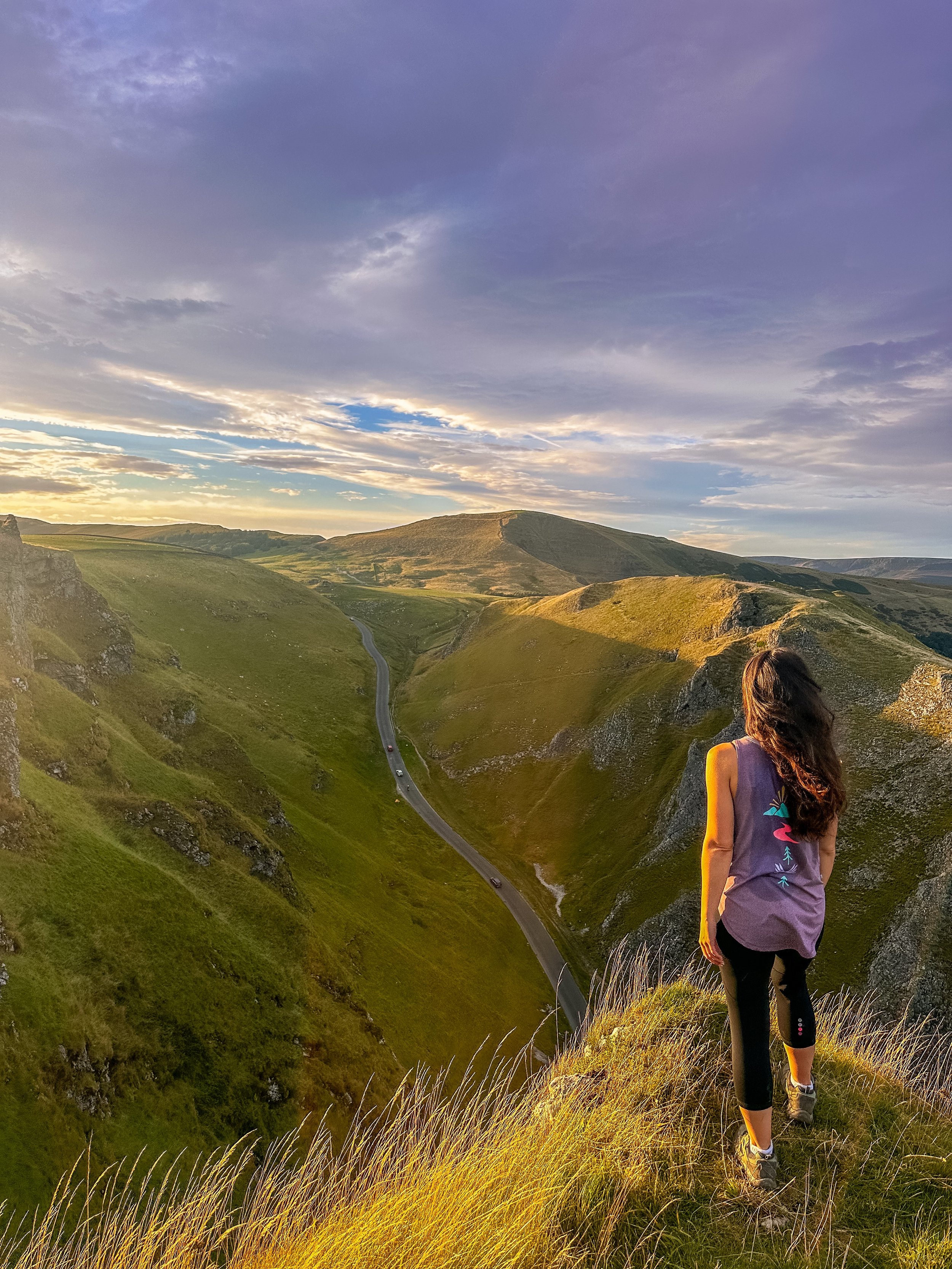
Once atop Winnats Pass, you’ll follow a trail that leads close to the boundary wall and takes you along the top of the pass. Be sure to stop and take in the views on this part of the walk. We were blown away watching the tiny cars winding their way through the pass. From here, you’ll head along a footpath in the direction of Mam Tor, before taking a detour to Odin Mine: a disused mine thought to be in use since 1260. The landscape surrounding makes for great exploring, leading you to the collapsed road constructed beneath Mam Tor.
When you reach Treak Cliff Cavern, look out for signs that tell you about the history of the area. Winnats Pass and the surrounding environment was once under a tropical sea, making the site protected by law due to the many fossils of sea creatures which lived here over 350 million years ago.
The valley was created by melting glaciers which gradually dissolved, creating streams which flowed through and under cracks in the rock. One of these streams created a large underground cave system which eventually collapsed, leaving behind the Winnats Pass you see today.

Route difficulty
There are first section of this route is a tough descent with a rope in place to support you. This may sound off-putting to some, but it’s all part of the adventure — and well worth it for the epic views.
If the above doesn’t sound manageable to you, then this walk is easily adjustable (options below), yet still enjoy the best sections of the walk.
Adjusting the route
You can avoid the super steep incline at the beginning of the walk and by following the road the cars do. You’ll find a path alongside the road for walkers. We’ve done both on different occasions and while this is certainly an easier option, that doesn’t mean it’s not a little bit tough. The distance will also be roughly the same.
Route highlights
Winnats Pass
Visiting Winnats Pass walk is an absolute must if you’re heading to the Peak District National Park. The surrounds feel truly magical and the history of how it came to be is mind-blowing. While many people head here to admire the awe-inspiring landscape, little put the effort in to go one step further and hike along the two ridges that encapsulate the pass — and this is where the very best views can be found.
What is Winnats Pass?
Winnats Pass is a road that leads through the Peak District National Park with huge rugged hillsides on either side. It’s truly spectacular and has an impressive history; over 340 million years ago, the entire area was below the sea – Winnats Pass in particular is thought to have been a coral reef. Once you know this, it’s easy to believe this is true as the surfaces represent exactly that.
Odin’s Mine
Odin’s Mine, tucked away beneath Mam Tor, is one of England’s oldest known lead mines, with records dating back to the 13th century. Situated beneath the famous Mam Tor, it played a crucial role in the area’s mining heritage, supplying lead for everything from building to plumbing during medieval times. These days, it’s a fascinating spot for history buffs and outdoor lovers alike. Whether you’re exploring its atmospheric cave entrances or just soaking up the surrounding beauty, Odin’s Mine offers a unique window into Castleton’s industrial past.
Collapsed Road
The collapsed road near Castleton, often called "The Broken Road," is a fascinating spot that really shows off the power of nature. Running beneath Mam Tor, also known as the "Shivering Mountain" because of its shifting layers, this road was abandoned in the 1970s after constant landslides made it impossible to keep up. Now, the crumbled tarmac and dramatic surroundings attract plenty of walkers and photographers. It’s a great place to explore, offering not only a unique piece of history but also some breathtaking views of the Peak District’s rugged beauty.
Castleton
Once you’ve parked up in the picturesque village of Castleton, you’ll leave behind the quaint coffee shops and artisan ice-creams to find a long country road. You won’t need to follow this road for long before getting sight of the mystical Winnats Pass.

Where is Winnats Pass?
Winnats Pass is located in what’s known as the Hope Valley area of the Peak District National Park. It’s close to many other great walks in the area and is situated near the popular village of Castleton.
Getting to the starting point
Arriving by car
The Peak District National Park is made up of country roads, tiny villages and heaps of fields. The quickest and easiest way to get around is by car.
The trail begins in the nearby village of Castleton where you’ll find ample of places to park. We parked in Castleton Car Park. The postcode for this is S33 8WH and costs £2.50 for 2 hours, with the option to stay for longer if required.
Public transport
If you’re unable to drive or prefer to take public transport, then taking the bus is the best option since there isn’t a train station near the beginning of this walk. If you’re travelling to Manchester, take the train to Hope and catch the 62 bus to Castleton.

✔️ Good to knows
Winnats Pass: There are several routes up to Winnats Pass which don’t require the steep ascent with the climber’s rope. Decide if the steep ascent is for you before visiting and amend the route accordingly. You can do this easily using OS Maps or komoot.
Footwear: If you choose to follow our steeper route, definitley boot up for this one. You’ll need to navigate loose rock and uneven terrain on the ascent.
Food and drink: When you arrive back in the lovely little village of Castleton, you’ll be spoilt for choice when it comes to choosing somewhere to eat. You’ll be inundated with ice-cream options, cafes and some cracking pubs with excellent beer gardens, too. You canalso go back to basics and grab some fish and chips and sit by the river. Below are some of the locations we’ve tried and can recommend:
The George (pub)
Ye Old Nags Head (pub)
Rose Cottage (cafe)
Castleton Fish and Chips
Parking: We parked at Castleton Car Park (S33 8WH).
Public transport: Travelling from Manchester? Take the train from Manchester Piccadilly to Hope (48 mins), then either walk or catch the 62 bus to the starting point. Walking adds on 1.6 miles each way.
🧭 Following the route
I use komoot and OS Maps for offline navigation. To follow this walk step-by-step on komoot, simply click this link here or download the GPX file and upload it to your chosen app, such as OS Maps.
Fancy giving this one ago? Check out our full guide on Instagram
More routes like this one: