ALL TRAILS
Cheesden Valley: a ruined valley ramble near Manchester
A 7.5-mile circular walk through an unexpected pocket of wilderness in Greater Manchester, featuring mill ruins, chimney stacks, pubs, hidden waterfalls and a woodland tearoom just outside Rochdale
Start: Owd Betts lay-by, Edenfield Road, Greater Manchester
Distance: 7.5 miles
Elevation: 725 feet
Duration: 3 hours
Difficulty: Easy (with some slippery sections in the colder months)
Navigation: Follow step-by-step on komoot or download GPX file
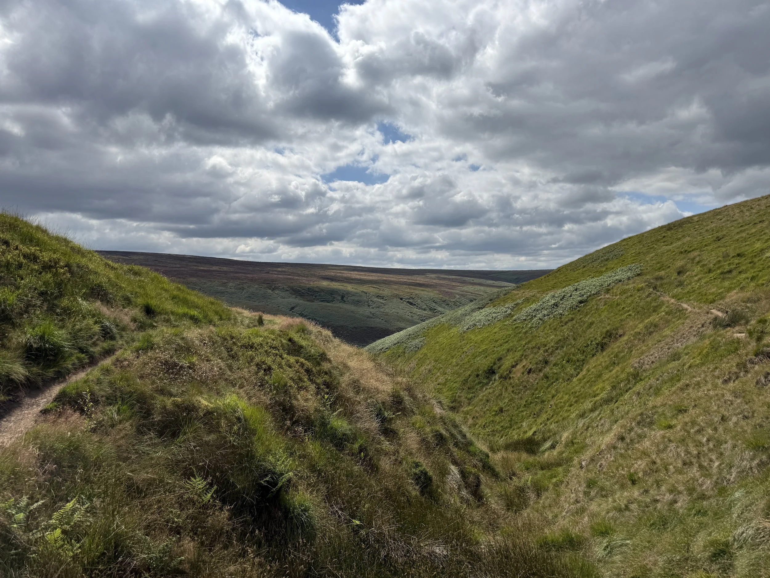
About the route
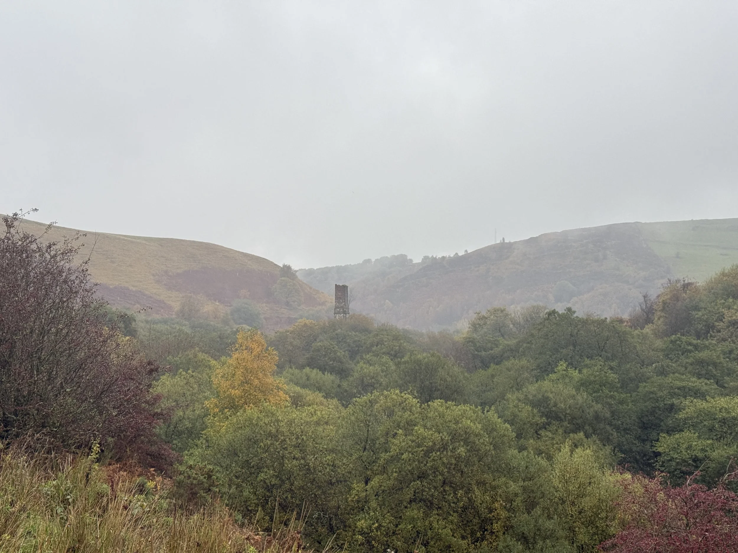
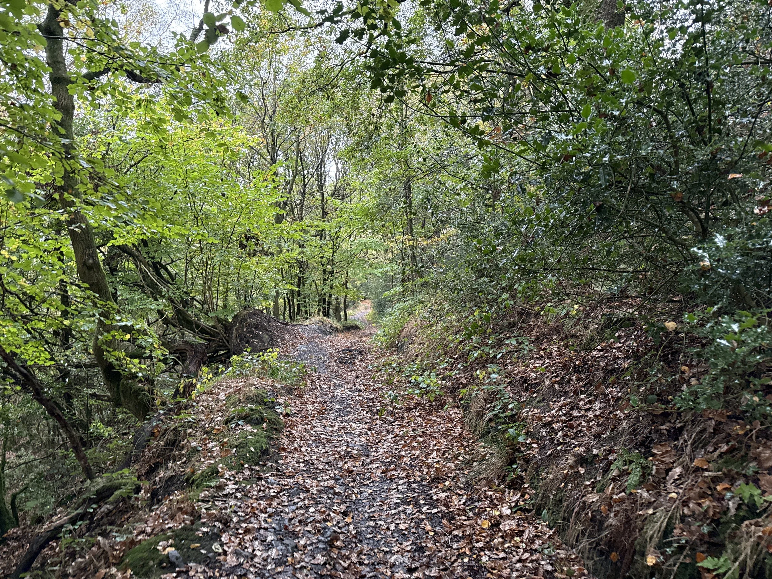
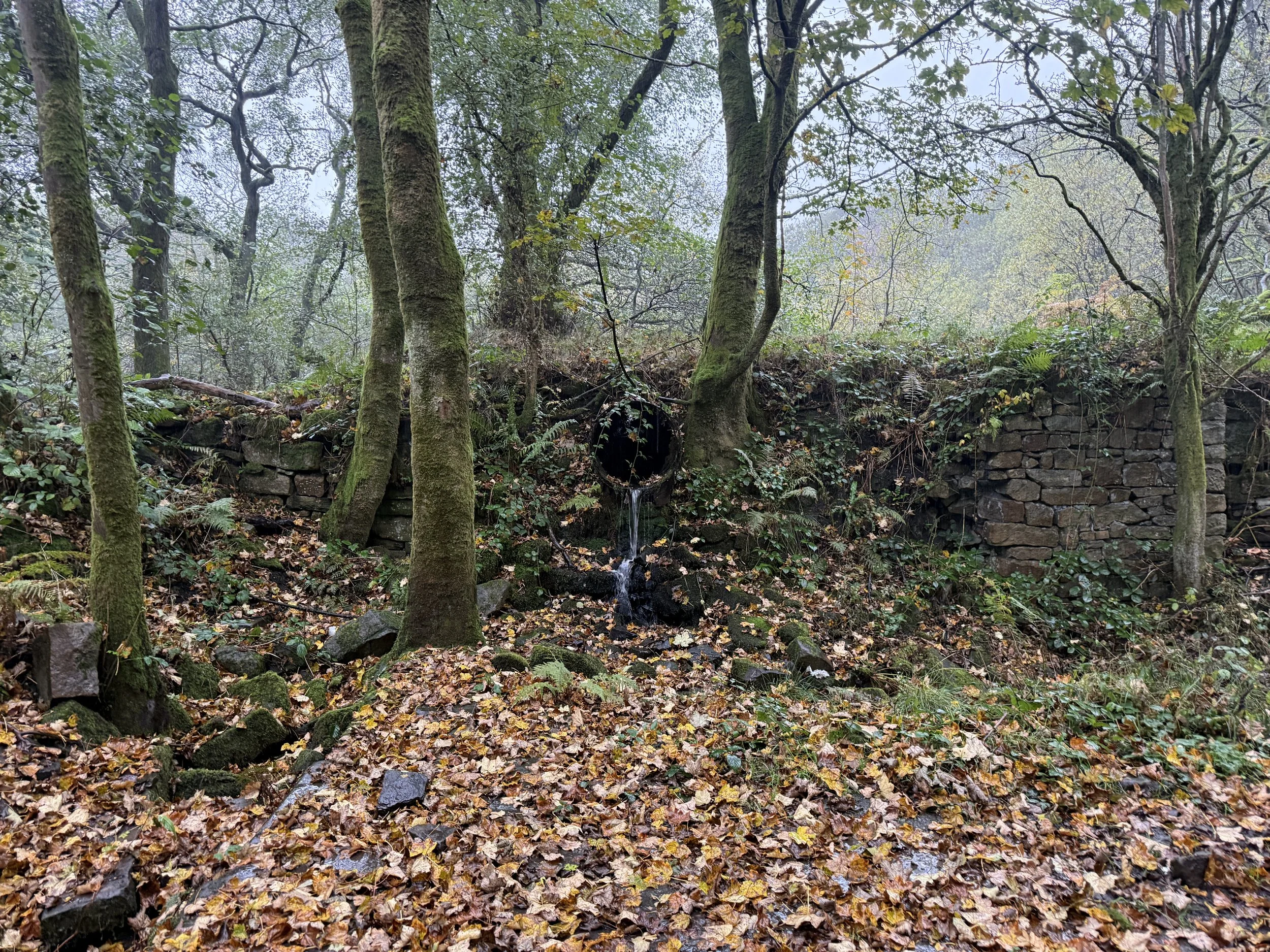
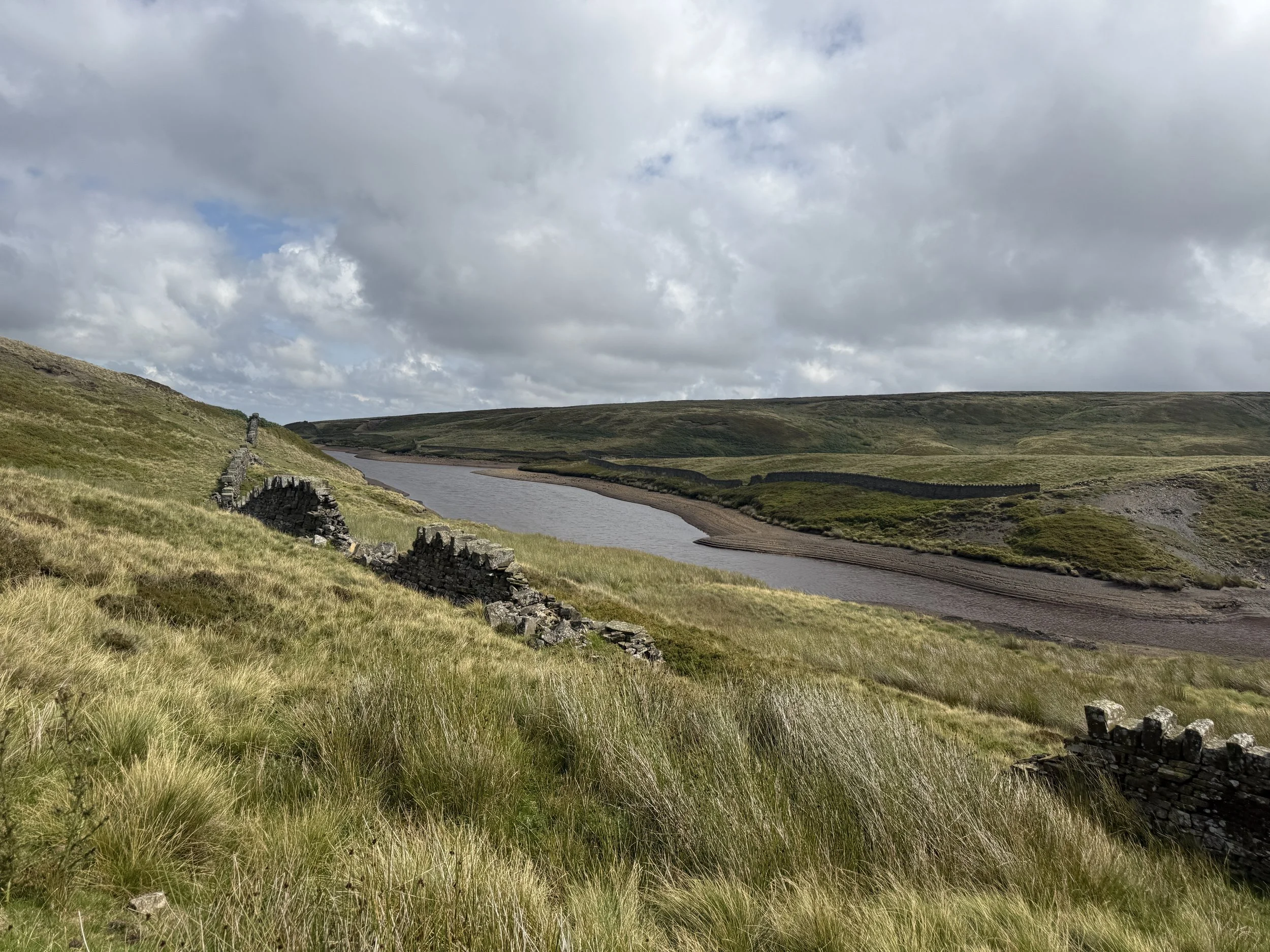
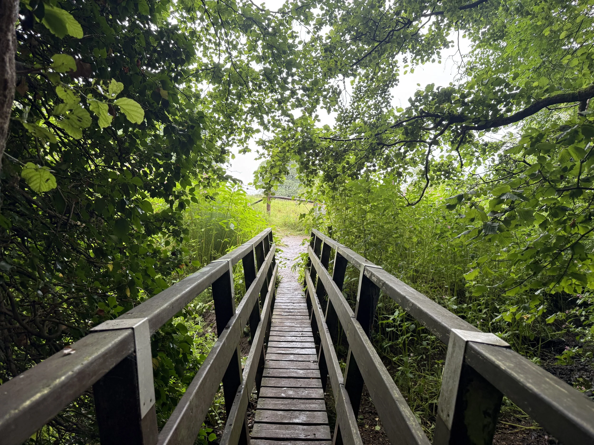
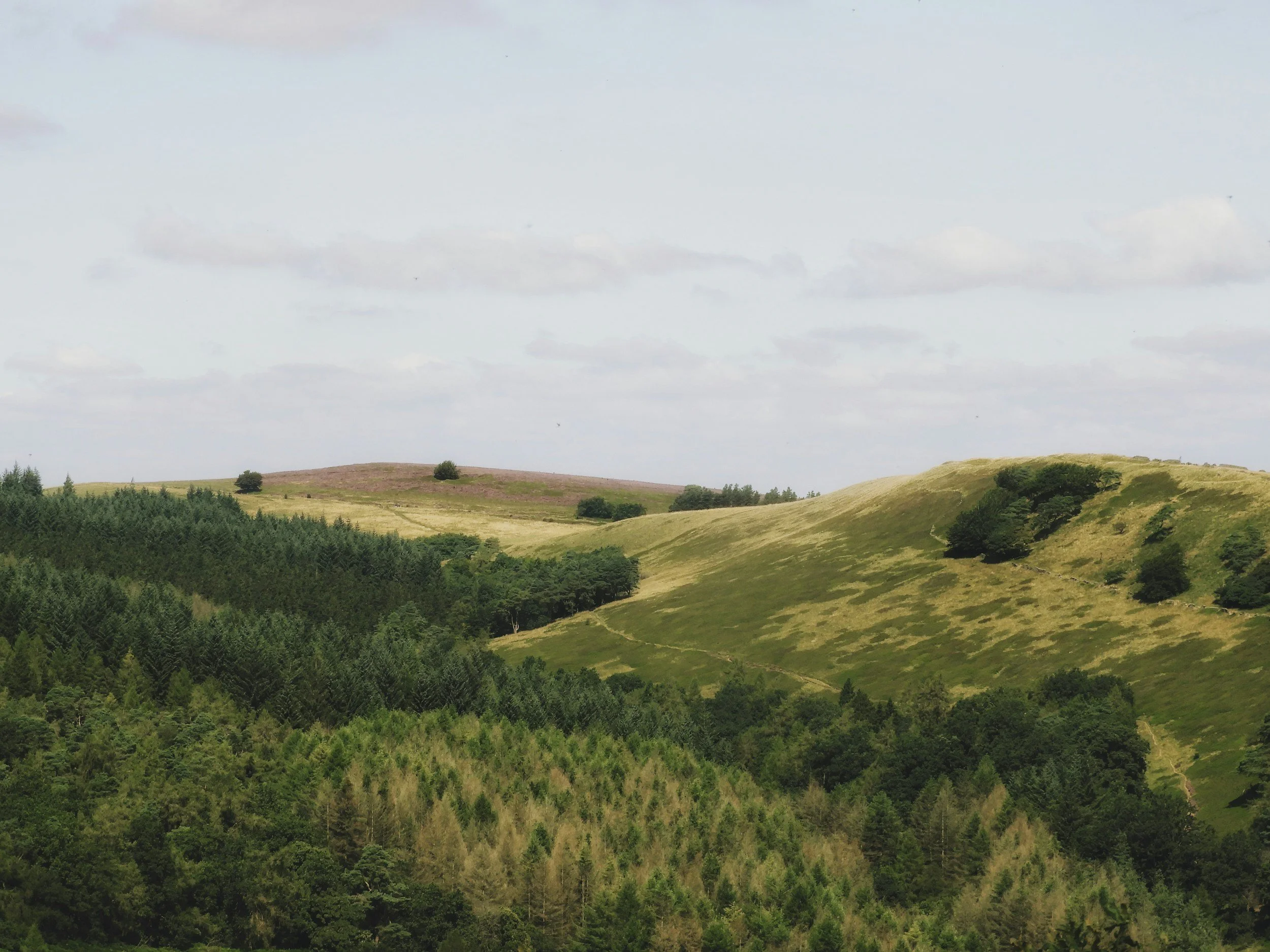
This circular walk begins at the lay-by near the historic Owd Betts pub and loops through the Cheesden Valley — an area rich in industrial heritage and natural beauty. You’ll descend into a wooded gorge, follow Cheesden Brook past the ruins of old mills and weirs, spot a dramatic chimney stack rising through the trees, and pass a tucked-away waterfall before climbing out of the valley to return via moorland paths and a tea stop near Norden.
This route started off as a spontaneous wander while in the area and it turned out to be one of my all-time favourite low-level walks. I wasn’t expecting much from this one, but those walks often turn out to be the best, don’t they?
Route difficulty
This is an easy to moderate walk with a mix of woodland trails, uneven valley paths, and field edges. There’s around 800 feet of elevation, with most of the climbing as you leave the valley mid-route. The paths are generally easy to follow but can be muddy, particularly after rain. Good boots are a must. While it’s low-level in terms of elevation, this is a proper walk—not a gentle parkland stroll.
| Walk type | Circular |
|---|---|
| Distance | 7.5 miles / 12 km |
| Time | 3.5–4 hours (plus stops) |
| Start/finish | Owd Betts lay-by, Edenfield Road |
| Terrain | Valley paths, woodland trails, moorland edge tracks |
| Difficulty | Moderate, with steeper/muddy sections |
| Good for | Unexpected views, industrial history, spontaneous adventures |
| Facilities | Pub, tearoom (limited hours), roadside parking |
Route highlights
Cheesden Lumb Mill: One of many atmospheric ruins along the brook — built in 1786 and now overgrown but still impressive..
Chimney stack: A tall, photogenic relic of Cheesden’s industrial past, rising through the woods like something from a lost world.
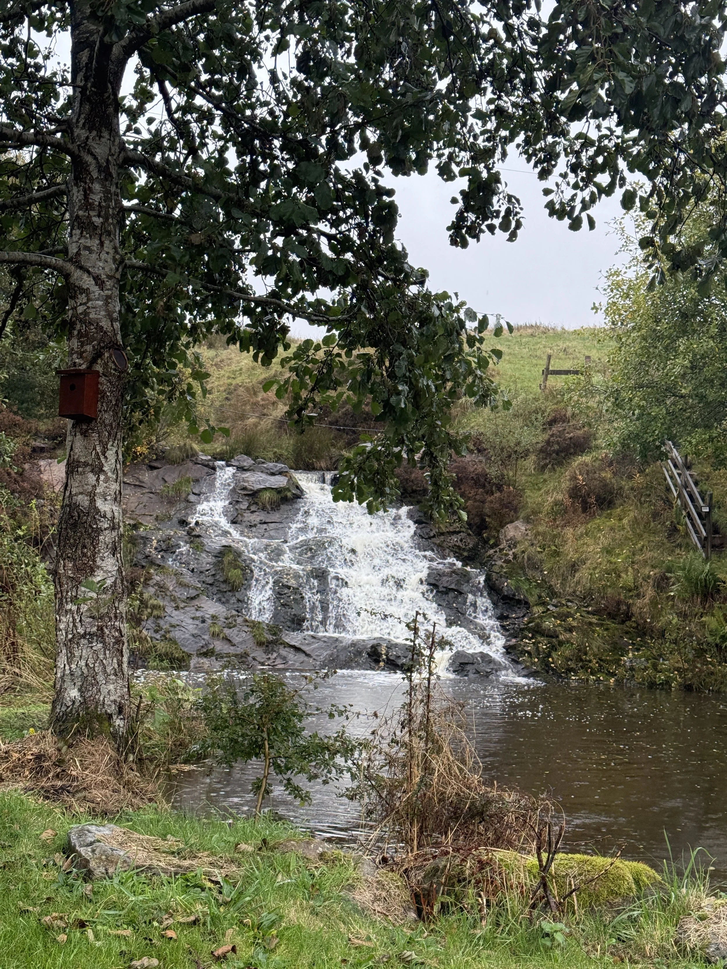
Cheesden Brook & waterfall: Follow the water through the valley and keep an eye out for a waterfall tucked to the side of the trail.
Wildlife sightings: Keep an eye out for wild deer in the woodland near the tea garden (couldn’t believe my eyes seeing wild deer just a few miles outside of Rochdale!).
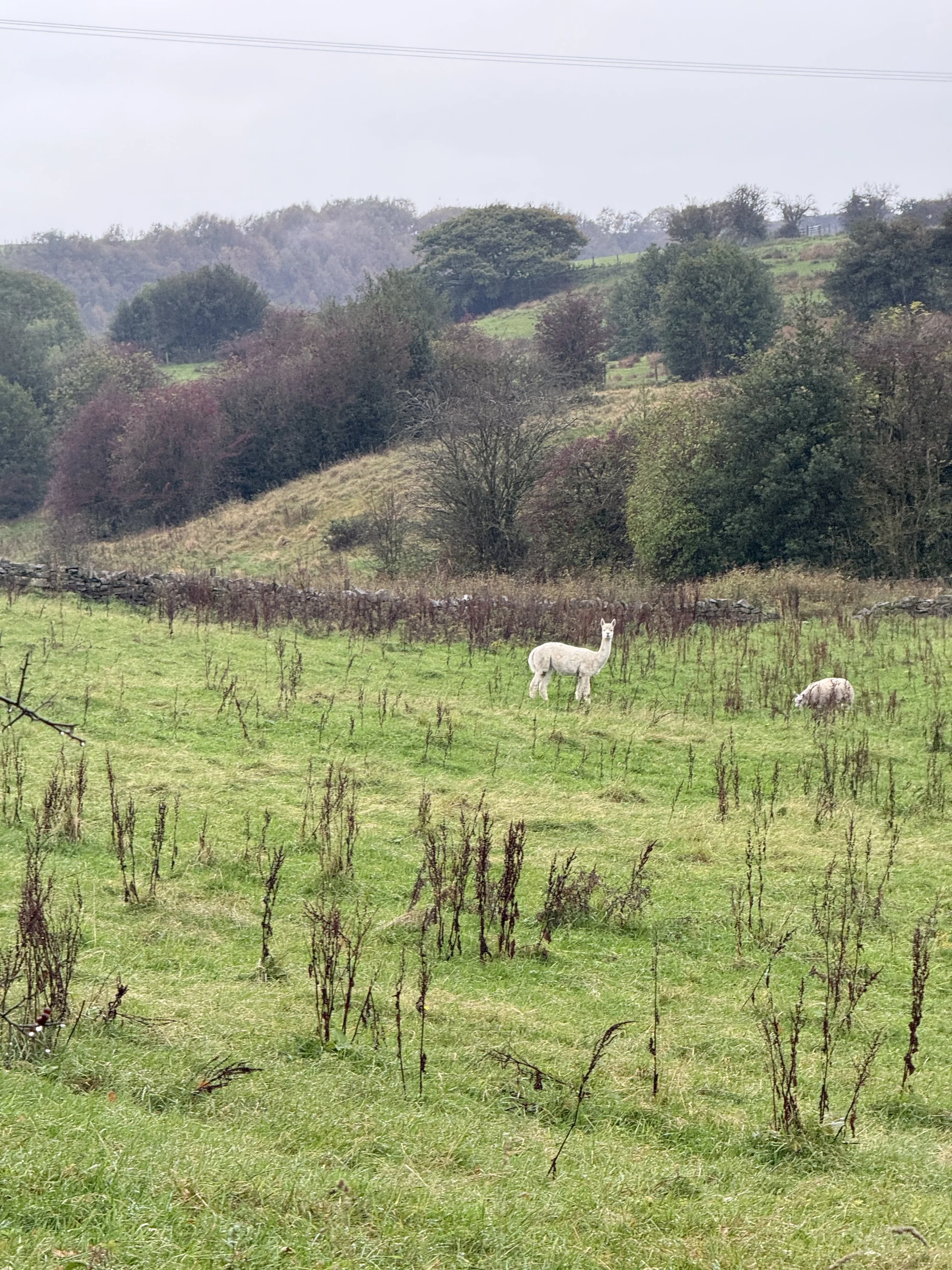
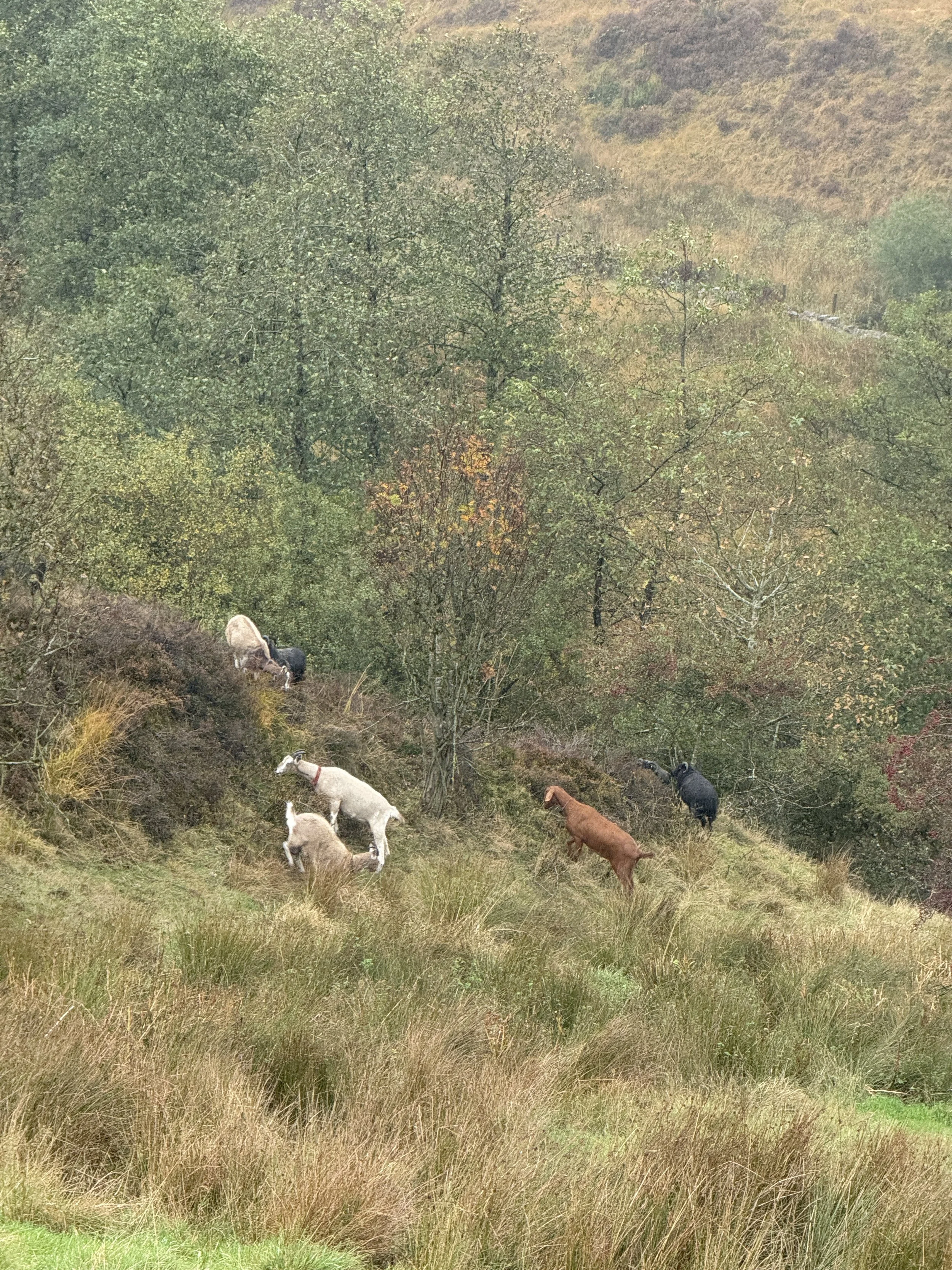
Goats and alpacas: Keep your eyes peeled near the fields and enclosures for goats and alpacas (a highlight of the walk for me!).
Moorland views: As you climb back out of the valley, views open up toward Greater Manchester and beyond.
Millcroft Tea Garden: A beautiful, old-school tea room hidden away in the woodland — only open on Sundays (12pm-6pm).
Where is Cheesden Valley?
Cheesden Valley lies between Rochdale and Edenfield, within the Greater Manchester boundary but feeling far wilder than its postcode suggests. It’s one of the best hidden-gem walks near Manchester — remote-feeling yet surprisingly accessible.
Things to do nearby
Visit Ashworth Moor Reservoir for a bonus short loop or picnic with a view.
Grab a post-walk pint at the Owd Betts pub (check opening times).
Tuck into tea and cake at Millcroft Tea Gardens (only open on Sundays, 12pm-6pm).
Explore more ruins by extending the route along other Cheesden Brook mill sites.
Is this walk suitable for beginners?
Absolutely, with some caveats. If you’re new to walking but happy to cover 7+ miles over a few hours, and don’t mind mud or mild climbs, this route is for you. The terrain isn’t difficult, but some parts can get super muddy, especially after heavy rain. Navigation is straightforward with a downloaded route.
Is the route dog-friendly?
Dogs are welcome throughout most of the route, including the trails and woodland. They must be kept on leads around livestock.
When is the best time to do this walk?
Spring/summer: Green woodland, flowing water, chance of deer sightings
Autumn: Gorgeous leaf colour and atmospheric light (save this one for autumn if you can!)
After rain: The waterfall is fuller, but the paths can be slippery
Avoid heavy downpours: It can get boggy and slow-going
How to extend your adventure
Add on Knowl Hill for extra views and more challenging elevation
Loop around Ashworth Moor Reservoir before or after the main route
Link to nearby moorland tracks if you want a longer day out
Visit the site of Deeply Vale Festival for a quirky local history detour
Getting to the starting point
By car: Park at the lay-by opposite the Owd Betts pub, Edenfield Road, OL12 7TY.
By public transport: Bus routes run from Rochdale and Bury, but you’ll likely need to walk a short way from the nearest stop.
✔️ Good to knows
Wear proper footwear the valley can get muddy, especially after rain
Millcroft Tea Gardens is only open on Sundays (12pm-6pm)
Bring a snack and water refreshment stops may be closed
Use a GPS route or Komoot navigation is mostly simple but a few turns can be missed
Dogs welcome on lead near livestock
Arrive early on weekends the lay-by is small and fills quickly
Mobile signal patchy download maps offline
Facilities: Pub at start/finish (check hours), tea room near Norden, no public toilets en route
🧭 Following the route
I use komoot and OS Maps for offline navigation. To follow this walk step-by-step on komoot, simply click this link here or download the GPX file and upload it to your chosen app, such as OS Maps.
Wessenden Valley Framing the Landscape Walk to Marsden
A stunning circular walk from the Wessenden Head “Framing the Landscape” frame down through the wild and beautiful Wessenden Valley, before finishing in the lively yet picturesque village of Marsden.
Start: Holme Moss Car Park, A6024 (above Holme village)
Distance: 7 miles
Duration: 2-3 hours
Elevation: 900 feet
Difficulty: Moderate – good paths but with some uneven, steep, and exposed sections
Navigation: Follow step-by-step on komoot, or download GPX file
About the route
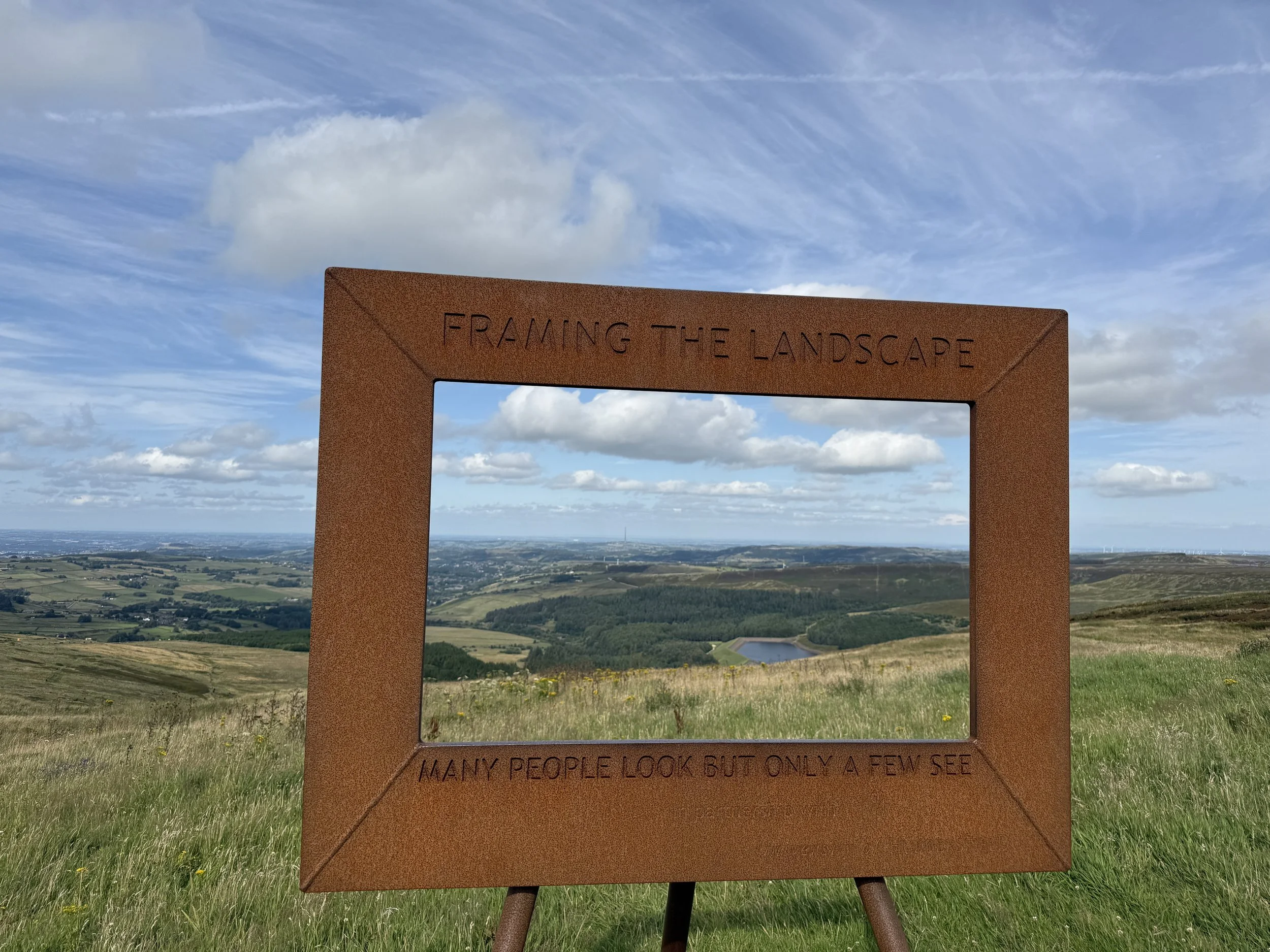
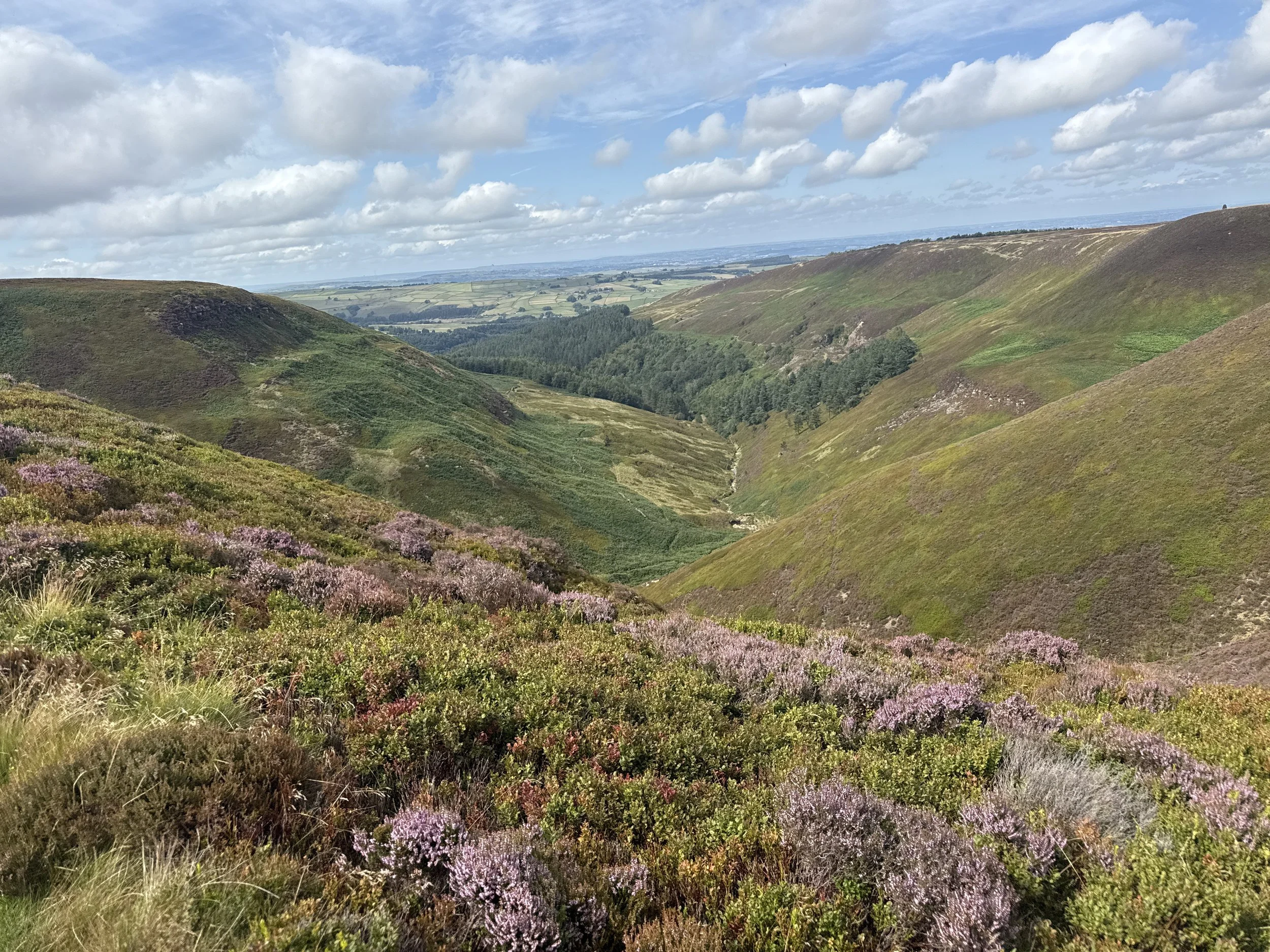
This high-moor circular starts right beside the Wessenden Head “Framing the Landscape” frame, one of six open-air art installations by Yorkshire artist Ashley Jackson in partnership with the National Trust. It’s perfectly positioned to frame the view down the Wessenden Valley – a glimpse of the epic scenery ahead.
From the layby, the route follows the Pennine Way down into the valley, passing a chain of four reservoirs – Wessenden Head, Wessenden, Blakeley, and Butterley. You’ll stop at Blakeley Clough waterfall, a hidden spot perfect for a summer paddle, before continuing into Marsden.
The return leg climbs gently back onto the moors, with far-reaching views towards Holme Moss and the surrounding hills, before rejoining Wessenden Head Road.
Route difficulty
Moderate. Most of the walk is on clear tracks or reservoir paths, but there are a few steeper climbs, rocky sections, and exposed moorland. A reasonable level of fitness and good footwear are recommended
Route highlights
Wessenden Head frame: A striking start and end point.
Blakeley Reservoir & waterfall: Peaceful, hidden, and beautiful.
Marsden village: A midpoint for coffee, cake, or a pint.
Butterley Reservoir: Impressive curved spillway and waterside path..
Why you’ll love this walk
Start and end at a Framing the Landscape art installation.
Four reservoirs in one loop – each with its own character.
The Blakeley Clough waterfall – a wild swimming/dipping gem.
A mix of valley walking and high-moor views.
Things to do nearby
Standedge Tunnel Visitor Centre – canal history and boat trips.
Holmfirth – moorland market town with shops, pubs, and galleries.
Holme Moss – another nearby frame if you’re collecting them all.
Getting to the starting point
By car: Park in the layby on Wessenden Head Road (HD9 4EU). Free parking for a handful of cars.
By public transport: Bus 352 runs between Holmfirth and Marsden, stopping near the start.
Following the route
I use komoot and OS Maps for offline navigation. Follow the full route step-by-step komoot, or download GPX file and upload it to your preferred app.
Good to knows
Footwear: Waterproof boots advised – moorland and reservoir paths can be wet year-round.
Exposure: This is a high-moor route; bring layers and waterproofs.
Dogs: Allowed, but keep on leads near livestock and on moors in nesting season
Holme Moss Framing the Landscape Walk
A short and easy moorland walk from Holme Moss car park to one of the Peak District’s striking “Framing the Landscape” art installations, with sweeping Dark Peak views from the very start
Start: Holme Moss Car Park, A6024 (above Holme village)
Distance: 8 miles
Duration: 3-4 hours
Elevation: 1,125 feet
Difficulty: Moderate - moorland paths, some uneven ground, a few steady climbs
Navigation: Follow step-by-step on komoot, or download GPX file
About the route
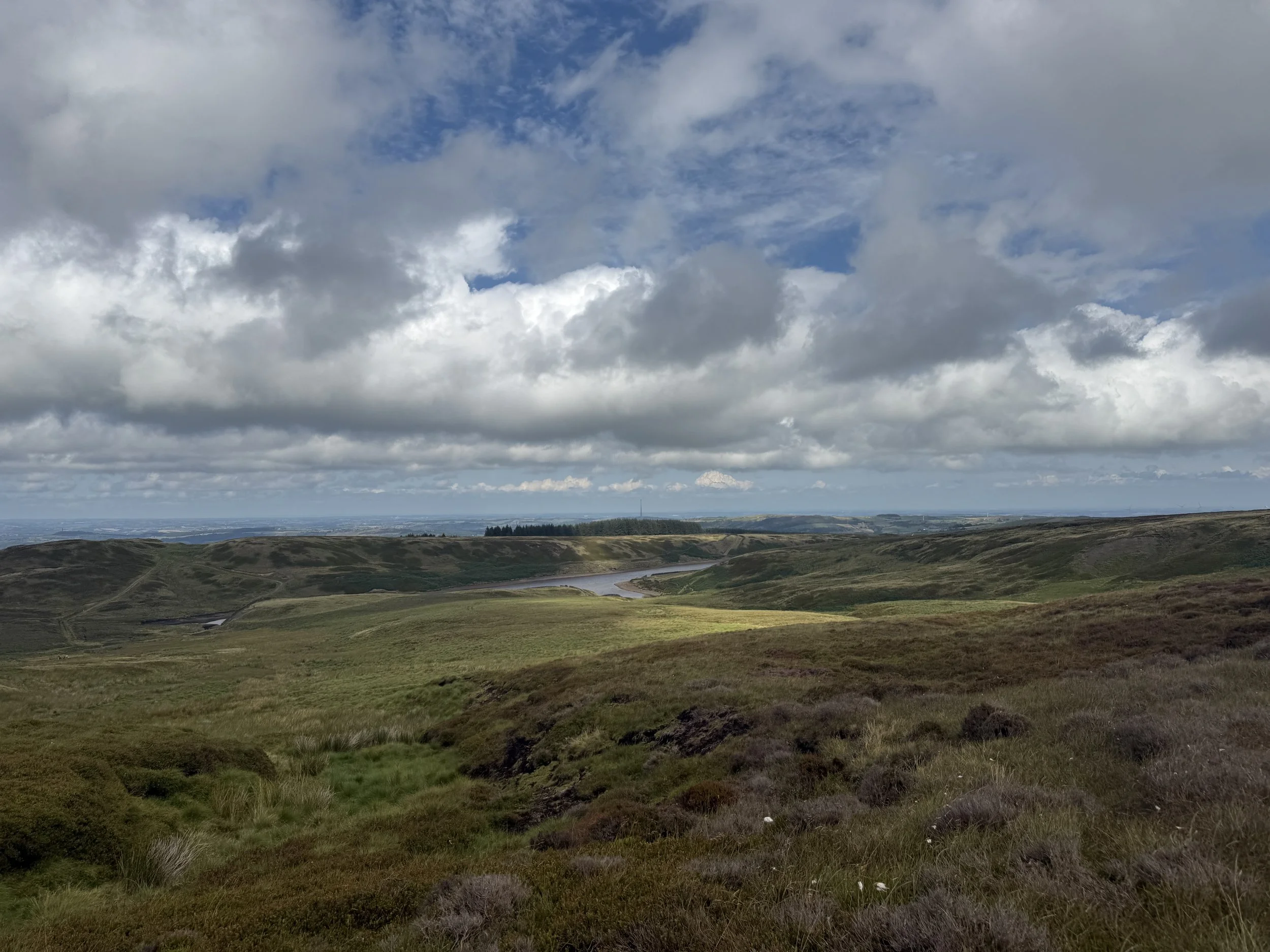
This is a full-day moorland walk that starts high on the A6024 at Holme Moss Car Park, immediately giving you huge views across the Dark Peak.
You’ll visit the Holme Moss “Framing the Landscape” frame, one of six open-air art installations by Yorkshire artist Ashley Jackson, before heading deeper onto the moors towards Snailsden Reservoir. The loop around Snailsden is wonderfully peaceful, with big sky views, heather-clad slopes, and glimpses of Yateholme Reservoir below.
The route has a mix of well-trodden paths and more rugged moorland tracks, making it a satisfying walk without being overly strenuous..
Route difficulty
Moderate. While there are no huge climbs, the distance, exposure, and occasional boggy patches mean it’s best suited to walkers with a reasonable level of fitness and decent footwear.
Route highlights
Holme Moss frame: Perfectly positioned for panoramic Dark Peak views.
Snailsden Reservoir: A quiet, secluded spot surrounded by wild moorland.
Yateholme views: A lovely vantage point over the reservoir and surrounding hills.
High moorland atmosphere: Ever-changing skies and a real sense of space.
Why you’ll love this walk
A unique blend of art and landscape – the Holme Moss frame makes for a standout photo stop.
Varied scenery – open moors, wild reservoirs, and far-reaching valley views.
Peaceful paths – Snailsden is quieter than the better-known Peak District reservoirs.
A satisfying circular route with big skies from start to finish.
Things to do nearby
Holmfirth: Enjoy lunch, coffee, or a browse in the town’s independent shops.
Digley Reservoir: A gentler, low-level reservoir walk just down the road.
The Fleece Inn, Holme: Cosy pub meals in a classic moorland village setting.
Getting to the starting point
By car: Park at Holme Moss Car Park (A6024, above Holme village). Free parking but limited spaces – get there early on sunny weekends.
By public transport: Buses run to Holme village; from there it’s a steep walk up the A6024 (no pavement in places – take care).
Following the route
I use komoot and OS Maps for offline navigation. Follow the full route step-by-step komoot, or download GPX file and upload it to your preferred app.
Good to knows
Footwear: Waterproof walking boots are essential – moorland sections can be boggy.
Navigation: Carry a map or GPX – some moorland paths are less defined.
Exposure: This is a high, open route – expect wind, even on calm days.
Dogs: Allowed on public rights of way (footpaths and bridleways), but keep them on a lead during bird-nesting season.
Dog restriction in place (2024–2029):
Dogs not permitted on the surrounding Open Access moorland (which part of this long route passes through).
How to extend your adventure
You could link this route with other moorland tracks towards Black Hill or Wessenden Head, ticking off another of the “Framing the Landscape” frames in the process.

The Tolkien Trail — Walk in the ƒootsteps of J.R.R Tolkien
This trail in Lancashire takes you through the landscapes that inspired Middle-earth.
Start: Hurst Green Memorial Hall Car Park
Distance: 6.73 miles
Duration: 2-3 hours
Elevation: 475 feet
Difficulty: Easy
Navigation: Follow step-by-step on komoot, or download GPX file
About the route
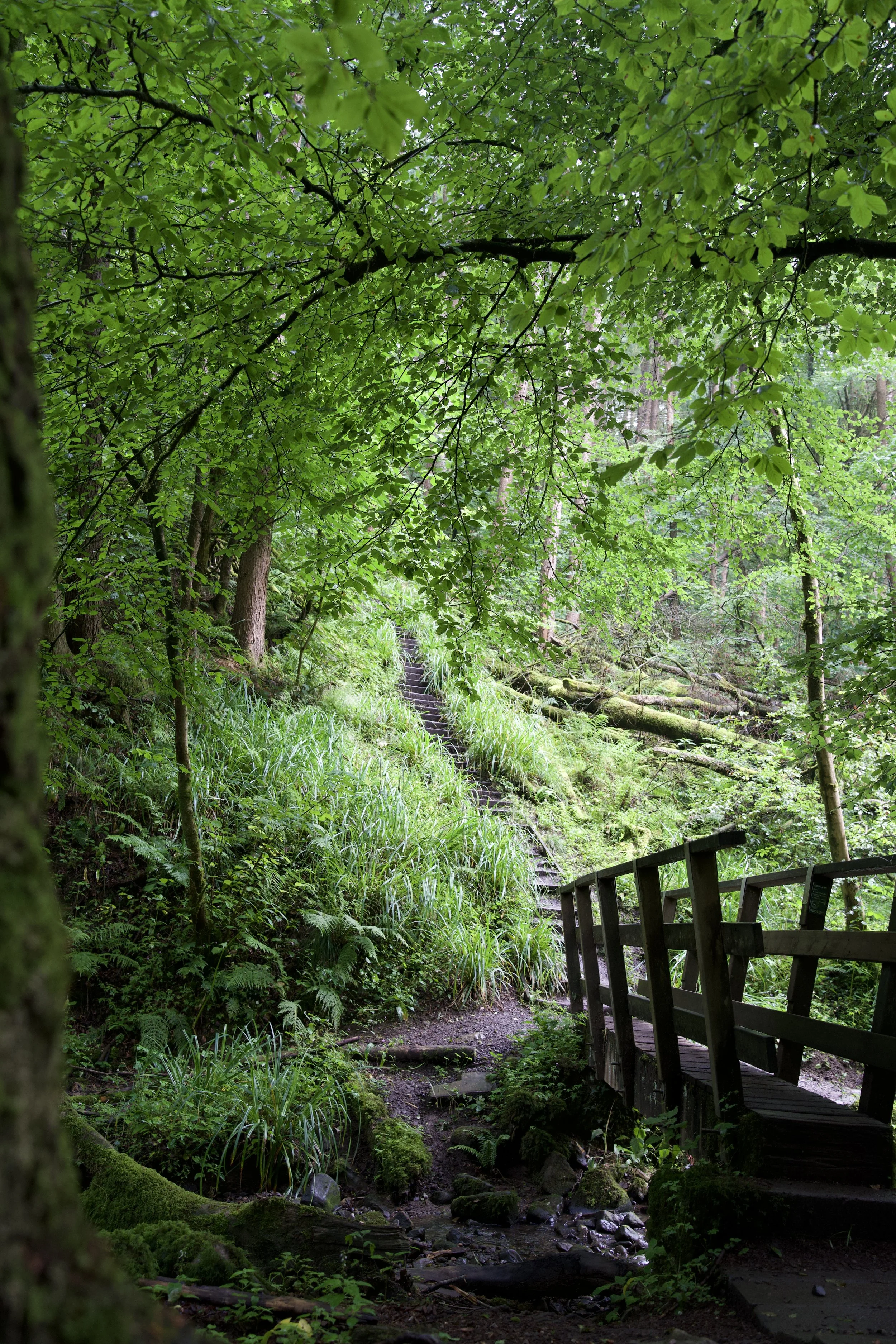
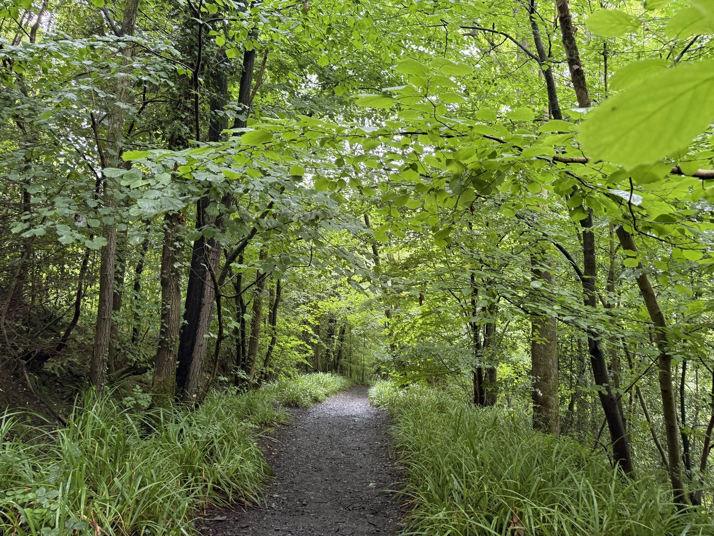
A circular walk from Hurst Green Memorial Hall car park, looping past Stonyhurst College, into Over Hacking Wood, alongside the River Hodder, over Cromwell’s Bridge, and back along the Ribble bank and aqueduct. Landscapes here are rumoured to have inspired parts of The Hobbit and The Lord of the Rings.
Route difficulty
This is an easy, beginner-friendly route with no major climbs. Paths can get muddy, but it’s otherwise straightforward and well-marked — perfect for a half-day adventure.
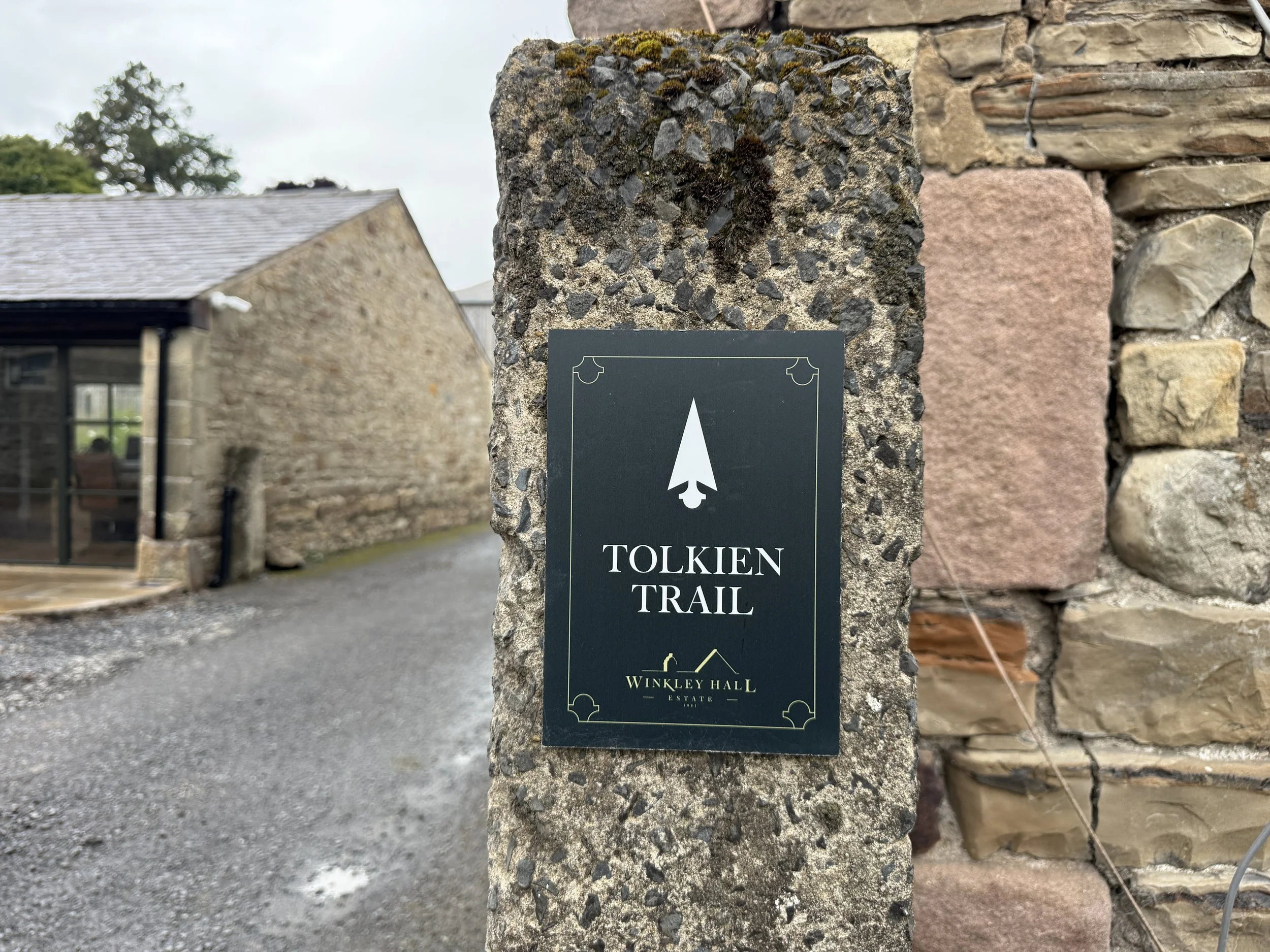
Why is it called the Tolkien Trail?
The trail is named after J.R.R. Tolkien, author of The Lord of the Rings, who spent time at Stonyhurst College during World War II while visiting his son, John, who was training for the priesthood. During his visits, Tolkien is believed to have written parts of The Lord of the Rings, drawing inspiration from the lush Ribble Valley countryside. Local place names like Shire Lane and the River Shirebourn bear striking similarities to the Shire and other elements of Middle-earth, making this a literary and scenic journey all in one.
Why you’ll love this walk
If you’ve ever dreamed of wandering through the Shire, this trail is for you. Peaceful riverside paths, ancient woodland, Tolkien lore around every bend, and a storybook pub stop to warm up mid-way. It’s atmospheric, historical, and just the right amount of whimsical.
Route highlights
Stonyhurst College — where Tolkien stayed during WW2 while visiting his son. Looks like Hogwarts, feels like history.
Shire Lane & River Shirebourn — local names that echo The Shire.
Hacking Boat House — believed to have inspired Buckleberry Ferry.
New Lodge viewpoint — possibly the real-life view from Tom Bombadil’s house.
The Shireburn Arms — cosy pub with LOTR vibes and great food.
Millie’s Café — home-baked cakes and a huge Middle-earth map on the wall.
Over Hacking Wood descent — woodland steps leading to verdant Hodder riverside.
River Hodder, Ribble & Cromwell’s Bridge — historic packhorse bridge said to have featured in local lore.
Views of Pendle Hill from fields above the riverside section — dramatic skyline.
Getting to the starting point
By train/bus: Train to Whalley or Clitheroe, then local buses (Clitheroe–Whalley–Preston) to Hurst Green. Check bus schedules for specifics.
By car: Sat nav to BB7 9QB. Park at the Memorial Hall car park (£5 donation recommended). Limited roadside space.
How to extend your adventure
Stonyhurst College museum (booking required) to explore Tolkien-related history.
Post-walk refreshment at The Shireburn Arms, Bayley Arms, or cake at Millie’s Café.
Extend into Forest of Bowland walks like Pendle Hill or Stocks Reservoir.
Is this walk suitable for beginners?
Yes, if you're okay walking ~3 hours over fields and riverside paths. Expect some mud in wet weather and around woodland stairs. A couple of short climbs but nothing too strenuous. Some of the route is way marked, but boots and route map advised.
When’s the best time to do this walk?
Late spring – early autumn is ideal for wild garlic and bluebells in Over Hacking Wood and clear riverside views. Winter is doable but muddy; waterproof footwear essential.
Following the route
I use komoot and OS Maps for offline navigation. Follow the full route step-by-step komoot, or download GPX file and upload it to your preferred app.
Good to knows
Waymarking minimal — Rely on map/GPX.
Footwear essential — Wooded and riverside bits can get muddy.
Dog friendly: Yes, dogs on leads near livestock.
Facilities: Toilets, pubs and café only in Hurst Green.
Countryside code: Close gates, pick up litter, stay on paths.

Best public transport walks near Manchester: Solomon’s Temple
A Peak District wander with woods, pubs, temples and plenty of sweet treats – no car required

Start: Buxton Station
Distance: 9.74 miles
Duration: 4 hours
Elevation: 1,275 feet
Difficulty: Moderate
Navigation: Follow step-by-step on komoot, or download GPX file
About the route
Looking for a cracking Peak District walk that ticks off skyline views, a brewery stop, and an easy train ride home? This 9-mile Buxton loop has a bit of everything: a public transport-friendly wander that’s big on moorland magic and post-walk pub stops.
Starting and ending in Buxton town centre, this 9-mile loop weaves together some of the best walking the area has to offer. You’ll climb up to Solomon’s Temple, climb to Corbar Cross, amble across peaceful moorland paths, and finish up with a well-earned beer at Buxton Brewery’s Trackside taproom. Along the way you’ll walk through parkland, Victorian gardens, and spa-town charm — the best of the Peak District in one day.
Route difficulty
Terrain: Mostly easy-going with a couple of uphill sections (Solomon’s Temple & Corbar)
Good for: Active beginners, solo hikers, or anyone after a moorland fix without needing a car

Why you’ll love this walk
Incredible views from Solomon’s Temple
Quiet, sweeping moorland paths
Trackside beers at Buxton Brewery
A stroll through Buxton’s Pavilion & gardens
Easy to reach by train or bus
Route highlights
Solomon’s Temple – A Victorian hilltop folly with 360° views over Buxton and the White Peak.
Corbar Cross – Hidden in the trees above Buxton, this striking iron cross is steeped in local history and great for a mid-hike breather.
Grin Low Country Park – Woodland trails and limestone grassland with a hint of mystery.
Trackside Taproom – Home of Buxton Brewery and a brilliant spot to fuel up after a long day’s walk.
Pavilion Gardens – A perfect spot for a brew and nosey around the gift shop mid-walk.
Things to do nearby
Buxton Pavilion Gardens – Ideal for a post-walk chill or cake stop
Buxton Museum & Art Gallery – Small, free, and surprisingly brilliant
The Crescent & Thermal Spa – Fancy a soak in some thermal waters? You’ve earned it.
Getting to the starting point
By train: Direct services from Manchester Piccadilly (≈1 hr) – Buxton station is a 5-min walk from the route start.
By bus: Hop on the 199 Skyline from Stockport or the 58 from Macclesfield.

How to extend your adventure
Got more in the legs? You can easily tag on the Dragon’s Back ridge by continuing west from Solomon’s Temple. It adds around 4 miles and takes you up into wild limestone country.
Is this walk suitable for beginners?
If you’re happy walking for 4–5 hours and don’t mind a few hills, this route’s a yes. The trails are clear and easy to follow, but comfy boots are a must.
When’s the best time to do this walk?
Late spring to early autumn is ideal, with longer days and drier trails. That said, this one’s a year-rounder with decent weatherproofs — just expect a few muddy sections in winter.

Following the route
I use komoot and OS Maps for offline navigation. To follow the full route step-by-step on komoot, click this link here or download the GPX file and upload it to your preferred app.
Good to knows
Public toilets at Pavilion Gardens
Picnic spots aplenty near Solomon’s Temple
Dog-friendly, but keep leads handy near livestock

Best public transport walks near Manchester: Upper Goyt Valley walk
A Peak District escape with woods, pubs, boardwalks and three peaceful reservoirs – no car required
Start: Whaley Bridge Station
Distance: 9 miles
Duration: 3-4 hours
Elevation: 950 feet
Difficulty: Moderate
Navigation: Follow step-by-step on komoot, or download GPX file
About the route
Looking for a cracking day walk without a car near Manchester? This scenic loop from Whaley Bridge station weaves through woodland, past not one but three reservoirs, with sweeping valley views and a boardwalk thrown in for good measure. It’s wild in parts, peaceful in others — and it starts and ends right by a trainline, a cafe, and lots of pubs.
Route difficulty
This is a manageable day walk for regular walkers. There are some steady ups and downs, especially through the valley section, and paths can get muddy in wet spells—but there’s nothing technical.
Walk type: Moderate
Terrain: Forest tracks, reservoir paths, gravel and grass trails
Accessibility: Not suitable for wheelchairs or pushchairs
Dog-friendly: Yes, on leads near water and livestock
Why you’ll love this walk
You can hop on the train and be hiking in under an hour
Three reservoirs, a woodland start, and moorland magic
Less trodden than tourist-heavy Peak routes
Peaceful paths and plenty of space to think
Lovely looped route with café options at the end
Route highlights
Hillbridge Wood
A peaceful green canopy to kick things off — look out for bluebells in spring.
Toddbrook Reservoir & dam
Cross the dam for big views and easy boardwalk strolling.
Fernilee Reservoir
More water, fewer people. A lovely stretch for snacks and a breather.
Goyt Valley
Big skies, open views, and winding tracks through heathered hills.
Errwood Reservoir
A scenic high point of the walk, often mirror-like on calm days.

Things to do nearby
Whaley Bridge cafés & pubs
Pop into Café 16 or The Bridge Bakehouse for excellent cake and coffee.
Explore Goyt Valley ruins
Add a mini detour to the old Errwood Hall ruins if you’ve got time.
Bookshop browse in Whaley Bridge
Whaley has a couple of secondhand gems for post-walk mooching.
Getting to the starting point
By train: Take a direct train from Manchester Piccadilly to Whaley Bridge (~50 minutes). Trains run regularly, even on weekends.
By car: Not needed. But if you must, there’s free parking at the station.

Following the route
I use komoot and OS Maps for offline navigation. To follow the full route step-by-step on komoot, click this link here or download the GPX file and upload it to your preferred app.
How to extend your adventure
Continue beyond Bowderdale Head for a full Howgill traverse
Detour east to Aygill Force waterfall
Explore more of the Rawthey Valley on a return loop
Is this walk suitable for beginners?
Yes, with some stamina. It’s not overly steep, but the 9-mile length makes it better suited to walkers with a few rambles under their belt. Pace it out, bring snacks, and enjoy the varied route.
When’s the best time to do this walk?
April to October offers the best conditions - lush trees, dry trails and mellow weather. The boardwalk gets slippery in winter, and the Goyt section can be boggy after heavy rain.

Good to knows
No toilets en route — use Whaley Bridge facilities before you start
Limited mobile signal in the valley—download maps beforehand
Sturdy boots essential after rain
Finish with a café stop — The Bridge Bakehouse is just across from the station

One of the best woodland walks near Manchester: A scenic loop from Pym Chair
Towering trees, panoramic views, and hidden ruins — this 6-mile Peak District walk has it all.
Start: Pym Chair Car park
Distance: 6 miles
Elevation: 975 feet
Duration: >3 hours
Difficulty: Moderate
Navigation: Follow step-by-step on komoot, or download GPX file
About the route
Sometimes you just need a long walk in the forest.
This circular walk from Pym Chair, nestled in the Goyt Valley, is one of the best hidden woodland walks near Manchester. It combines everything that’s great about walking in the Peak District: peaceful woodland trails, wide-open ridge walks, quiet historical landmarks, and some of the best sunset views in the area.
Starting at Pym Chair car park, the route takes you through dense forest and past the haunting ruins of Errwood Hall, then climbs gently up to St Joseph’s Shrine, and further still to the scenic ridge line of Shining Tor and Cats Tor. On a clear evening, these ridges are the perfect spot for a sunset.
💡 Planning more walks like this? Search Forestry England to find your nearest forest trails and hidden gems.

Route difficulty
Walk type: Moderate — manageable for most, but includes some inclines and uneven ground.
Terrain: Woodland trails, gravel paths, and open moorland ridges. Expect a few muddy patches after rain.
Accessibility: Not suitable for wheelchairs or buggies due to uneven terrain and steps near the ruins.
Dog-friendly: Yes, on leads. Keep an eye out for sheep and ground-nesting birds.
Why you’ll love this walk
🌲 Forest therapy: Walk beneath towering trees and along winding paths that feel far away from the city.
🌄 Sunset-worthy views: Shining Tor and Cats Tor offer panoramic views across Cheshire, the Peak District, and beyond — perfect for golden hour.
🏛 Mysterious ruins: Discover the atmospheric remains of Errwood Hall, a Victorian estate now slowly being reclaimed by nature.
⛪️ Hidden shrine: Tucked into a hillside, St Joseph’s Shrine offers a surprising and spiritual pause, rich with local history.
🐾 Dog-friendly: Well-behaved dogs are welcome on leads, especially around livestock. There’s plenty for them to sniff and explore.
Best woodland walk near Manchester?
If you're based in Manchester or the surrounding area, this walk is a brilliant half-day escape. It’s less than an hour’s drive, but you’ll feel like you’ve stepped into another world.
This loop through the Goyt Valley has a bit of everything: forest calm, hidden history, hilltop drama, and just the right level of challenge. Whether you’re a weekend wanderer or a seasoned hiker looking for a quieter trail — this one’s worth adding to your list.

Route highlights
Pym Chair
A remote-feeling spot with a Forestry England car park (and yes, it’s free). It's the perfect base for exploring this quieter corner of the Peak District. The name comes from a rocky outcrop nearby that resembles a chair, once used as a boundary marker centuries ago. Today, it’s a quiet spot with stunning views west toward Windgather Rocks and east over moorland. It’s also a prime starting point for multiple ridge walks, especially popular with photographers chasing late-afternoon light.
The car park is managed by Forestry England and is often quieter than other hotspots like Mam Tor or Kinder — making it a brilliant base if you want a less-crowded adventure.
Errwood Hall Ruins
These atmospheric ruins are all that remain of a once-grand country house. Built in the mid-1800s, Errwood Hall was once the luxurious home of the Grimshawe family, wealthy industrialists from Manchester. Though now only the stone foundations and arches remain, you can still walk through the footprint of the grand house, imagining the turrets and sweeping staircases that once stood here.
The ruins sit tucked away in the forest, with moss-covered walls and ivy climbing over crumbled windows — it feels a bit like stepping into a forgotten fairytale. In spring, you’ll often find the area dotted with bluebells and rhododendrons, planted by the Grimshawes themselves. It’s a peaceful spot to take a break, explore, and soak up the slightly haunting atmosphere.
St Joseph’s Shrine
Built by the Grimshawe family of Errwood Hall, this small shrine still attracts visitors and walkers. You’ll often find candles, flowers, or quiet reflections left behind. Just a short walk uphill from Errwood Hall, this small, stone-built shelter is tucked into the hillside. It was built by the Grimshawe family in memory of Miss Dolores de Ybarguen, a Spanish companion and teacher who lived with them. The shrine became a site of pilgrimage and quiet reflection and is still looked after today by local volunteers.
Inside, you’ll usually find candles, flowers, rosary beads, and notes left by visitors. Whether you're religious or not, it’s a touching and tranquil spot that adds a surprising layer of history to the walk. And if you’re into your photography, the view from just outside the shrine is especially photogenic, especially in soft morning light.
Shining Tor & Cats Tor
As the highest point in Cheshire at 559 metres, Shining Tor earns its place on any Peak District must-walk list. The path to the summit is steady rather than steep, and once you reach the top, you’ll be rewarded with wide-open views over the Cheshire Plain, Macclesfield Forest, and even out towards Snowdonia on a clear day.
From here, the trail continues along the ridge to Cats Tor — slightly lower in height, but arguably even better for sunsets. The ridgeline is exposed, with big skies and golden grasses that catch the light beautifully in the evening. It’s a great place to linger, grab a snack, and let the world slow down for a bit.

Getting to the starting point
By Car
Pym Chair Car Park is your best bet (postcode area: SK23 7RF). It’s run by Forestry England and is usually free. The drive up is narrow and scenic — go slow and enjoy the views.
By train/taxi
Public transport is limited here, but you can take a train to Whaley Bridge or Buxton, then hop in a taxi to Pym Chair.

✔️ Good to knows
Footwear: Waterproof hiking boots recommended — especially after rain.
Facilities: No toilets or cafés at Pym Chair — come prepared.
Nearby food: Head to Whaley Bridge, Buxton, or Fernilee after your walk for pubs, bakeries, and coffee spots.
🧭 Following the route
I use komoot and OS Maps for offline navigation. To follow the full walk step-by-step on komoot, simply click this link here or download the GPX file and upload it to your chosen app, such as OS Maps.

BEST SUNRISE WALK IN THE PEAK DISTRICT: WIN HILL AND LADY BOWER LOOP
This breathtaking Peak District walk offers stunning sunrise views over Ladybower Reservoir and beyond.

Start: what3words: shackles.chucks.butterfly (Small layby or street-side parking. Alternatively, park at Yorkshire Bridge Inn if you plan on being a customer).
Distance: 7 miles (Shorter option: ~2 miles out-and-back)
Elevation: 1,550 feet
Duration: 3 hours
Difficulty: Easy (with some moderate sections)
Navigation: Follow step-by-step on komoot, or download GPX file
About the route
Looking for an incredible sunrise walk near Manchester? This 7-mile circular walk to Win Hill offers some of the most breathtaking sunrise views in the Peak District. The route includes an ascent to Win Hill's summit, where you’ll get panoramic views over Ladybower Reservoir, Bamford Edge, and the surrounding hills, followed by a scenic loop past the dramatic Ladybower plugholes and dam.
If you’re short on time, you can opt for a shorter out-and-back route, reaching the summit in under 40 minutes (approximately 2 miles total).

Route difficulty
Difficulty: Easy-moderate (Steady climb to Win Hill, then easier descent)
Terrain: Well-defined trails, some rocky paths
Dog-Friendly: Yes, but keep dogs on leads near livestock

Route highlights
Win Hill Summit at Sunrise
The climb up to Win Hill is absolutely worth the effort, especially at sunrise. From the summit, you’ll be rewarded with incredible views over Ladybower Reservoir, the Great Ridge, and Kinder Scout. On clear mornings, the golden light floods the valley, and you may even be met with a cloud inversion.
Ladybower Plugholes & Dam
After descending from Win Hill, the walk takes you past the famous Ladybower plugholes—dramatic bellmouth spillways designed to control the reservoir’s water levels. These vast circular drains are mesmerizing when overflowing, creating a giant whirlpool effect. You can also cross Ladybower Dam for more scenic views.
Where to view the plugholes:
Roadside viewpoint near Yorkshire Bridge Inn
Viewing platform across the dam wall
Best seen in winter and spring when water levels are high
Yorkshire Bridge Inn – Perfect post-walk stop 🍻
If you fancy a rewarding breakfast or coffee after your walk, the Yorkshire Bridge Inn is a great spot. They offer a hearty breakfast menu, making it an ideal place to refuel before heading home.
Route difficulty
Full Loop (7 miles): Moderate difficulty due to elevation gain, but well-maintained paths make it manageable.
Shorter Route (2 miles out-and-back): Ideal for those who want a quicker sunrise experience with a rewarding summit.

Where to park?
Shackles.chucks.butterfly (what3words) – Small layby or roadside parking.
Yorkshire Bridge Inn – Parking available for customers.
Heatherdene Car Park (pay & display) – Toilets available; a short walk from Ladybower Dam.
Getting to the starting point
By Car:
From Manchester: ~50 minutes via A57 Snake Pass.
From Sheffield: ~40 minutes via A57.
By Public Transport:
Train to Bamford Station, then a ~25-minute walk to the start.

✔️ Good to knows
Best time to visit: For sunrise, aim to start your walk about an hour before sunrise time.
Footwear: Sturdy hiking boots recommended, as the ascent can be rocky.
Weather: Check the forecast—misty mornings can add to the atmosphere, but strong winds at the summit can be challenging.
Photography tip: The best angles for sunrise shots are from the trig point at the summit, looking east over Hope Valley.
🧭 Following the route
I use komoot and OS Maps for offline navigation. To follow the flatter walk step-by-step on komoot, simply click this link here or download the GPX file and upload it to your chosen app, such as OS Maps.

EASY WALK NEAR MANCHESTER: MILLENIUM WALKWAY
This stunning Peak District walk hovers above a huge natural gorge

Start: New Mills Train Station, High Peak, SK22 3JB
Distance: 4 miles
Elevation: 175 feet
Duration: Less than 2 hours
Difficulty: Easy
Navigation: Follow step-by-step on komoot, or download GPX file
About the route
Looking for an easy yet jaw-dropping walk near Manchester? This 4-mile circular route through New Mills and the dramatic Millennium Walkway offers a perfect mix of industrial history and natural beauty. With minimal elevation and well-maintained paths, it's a great option for those seeking a relaxing yet visually stunning escape.
The walk takes you through The Torrs Riverside Park, past the spectacular Millennium Walkway, and along the Sett Valley Trail. With easy transport links and a great selection of cafés and pubs in New Mills, it’s perfect for your next gentle stroll.

Route difficulty
Walk type: Easy with minimal elevation gain.
Terrain: Well-defined paths, mostly flat.
Accessibility: Not suitable for pushchairs or wheelchairs.
Dog-Friendly: Yes

Route highlights
The Torrs Millennium Walkway
This unique 175-yard aerial walkway is suspended over the River Goyt, hugging the rock face of the dramatic Torrs Gorge. Originally impassable, the walkway was built at the turn of the millennium and is nicknamed the ‘steel spider’s web’ for its striking design.
The Torrs Riverside Park
Known locally as ‘the park under the town,’ this stunning gorge is home to remnants of New Mills’ industrial past. Old mill ruins, rushing weirs, and the convergence of the River Goyt and River Sett make for a striking backdrop.
Sett Valley Trail
Following an old railway line, this scenic and flat path stretches between New Mills and Hayfield, offering beautiful Peak District views.
New Mills Heritage Centre
A great stop for those interested in the town’s industrial history. The centre provides maps, information, and exhibits about New Mills' past, including the Kinder Mass Trespass.
Local Cafés & Pubs
After the walk, stop for a bite to eat in one of New Mills’ many independent cafés. The Sett Valley Café (a little further along the Sett Valley Trail) is a great option for homemade and vegan treats, while the Pride of the Peaks pub offers hearty meals and local ales.
Is this route for me?
This walk is perfect for families, beginners, and those looking for a scenic yet easygoing route.

Options to extend the route: sunset walk to Mellor Cross
Start: New Mills Station
Distance: 4.72 miles
Elevation: 750 feet
Duration: 2.5 hours
Difficulty: Moderate, some uneven terrain
Navigation: Follow along on komoot or download GPX file
Mellor Cross, perched on Cobden Edge, is a spectacular sunset viewpoint near Manchester. The short but rewarding extension from New Mills leads you through open countryside to this peaceful spot, offering uninterrupted views over the Peak District and beyond.
If you want to extend the route further, you can continue towards the Roman Lakes and Mellor Mill ruins for more historical interest and scenic walking trails before looping back to New Mills.

Getting to the starting point
By Car:
You’ll find plenty of parking available in New Mills town centre. We parked at Market Street Carpark (SK22 4AA). Parking costs approximately £2 for 4 hours.
By Public Transport:
New Mills is easily accessible by train, with direct services from Manchester.

✔️ Good to knows
Difficulty: Easy with minimal elevation, moderate if extending to Mellor Cross.
Footwear: Comfortable walking shoes; boots recommended if heading to Mellor Cross.
Dog-Friendly: Dogs are welcome but should be kept on leads near wildlife.
Food & Drink: Plenty of cafés and pubs in New Mills, including the Sett Valley Café and Pride of the Peaks.
🧭 Following the route
I use komoot and OS Maps for offline navigation. To follow the flatter walk step-by-step on komoot, simply click this link here or download the GPX file and upload it to your chosen app, such as OS Maps.

EASY WALK NEAR MANCHESTER: HEALEY DELL
This scenic and historic walk near Manchester is steeped in myth and offers stunning natural beauty

Start: Healey Dell Nature Reserve, Rochdale, OL12 6LW
Distance: 4 miles
Elevation: 375 feet
Duration: Less than 2 hours
Difficulty: Easy
Navigation: Follow step-by-step on komoot, or download GPX file
About the route
Looking for an easy yet breathtaking walk near Manchester? This 4-mile circular route through Healey Dell Nature Reserve offers a perfect mix of history, legend, and natural beauty (and a stunning tea room where you can grab a proper brew, for good measure). With gentle elevation and well-maintained paths, it’s a great one to save if you’re seeking a peaceful escape from the city without a strenuous climb.
From the enchanting Fairies Chapel and stunning Healey Dell Waterfalls to the historic Prickshaw Village and the welcoming Healey Dell Heritage Tea Rooms, this walk is a true hidden gem. You’ll also join parts of the Rossendale Way and Mary Towneley Loop, so there’s plenty of options to extend the route if you’re looking for a longer day out.

Route difficulty
Walk type: Easy circular walk with minimal elevation gain.
Terrain: Well-defined paths, mostly even but with some uneven sections.
Accessibility: Not suitable for pushchairs or wheelchairs.
Dog-Friendly: Yes

Route highlights
Healey Dell Nature Reserve
Once a 19th-century industrial area, this now-thriving nature reserve is known for its lush woodland, dramatic gorges, and rich wildlife. Keep an eye out for rare birds, and remnants of the old railway that once passed through the reserve.
Fairies Chapel
This mystical rock formation, nestled deep within the reserve, is steeped in legend. According to folklore, it was once a sacred site for fairies and spirits. The atmospheric setting, with moss-covered stone and trickling water, makes it easy to see why.
Healey Dell Waterfalls
One of the main attractions of the walk, these cascading waterfalls provide a serene and photogenic stop along the route.
Healey Dell Heritage Tea Rooms
A must-visit! This charming, vintage-style tea room is housed in an old mill building and offers delicious homemade treats, perfect for a mid-walk break.
Prickshaw Village
A hidden gem along the route, this well-preserved 17th-century hamlet feels like a step back in time. With its cobbled streets and traditional stone cottages, it’s a fascinating glimpse into Rochdale’s history.
Rossendale Way & Mary Towneley Loop
Sections of this walk overlap with two renowned long-distance trails. If you’re feeling adventurous, these trails offer fantastic opportunities for extending your route beyond Healey Dell.

Is this route for me?
Unlike more strenuous routes nearby, this walk is ideal for families, beginners, and those wanting a scenic yet manageable walk. It’s also dog-friendly (on leads), so it’s a great one to save for a day out with the little ones and pooches.

Options to extend the route / things to do nearby
If you’re looking to make a full day of it, take a look at these longer options nearby:
Explore the Rossendale Way: Follow this scenic trail deeper into the Rossendale Valley.
Mary Towneley Loop: Extend your hike along this picturesque long-distance route, offering stunning Pennine landscapes.
Hollingworth Lake: A beautiful reservoir just a short drive away, perfect for waterside strolls and picnics.
Healey Stones & Knowl Hill: A slightly more challenging hike nearby, offering panoramic views over Rochdale and beyond.
Blackstone Edge: A dramatic gritstone escarpment on the Pennine Way, ideal for those looking for a longer adventure.
Getting to the starting point
By Car:
Use the postcode OL12 6LW for Healey Dell Nature Reserve car park. Parking is limited, so arriving early is recommended.
By Public Transport:
Rochdale is well-connected by train and bus. The nearest station is Rochdale Railway Station, with buses running regularly to Healey Dell.

✔️ Good to knows
Difficulty: Easy with gentle elevation gain.
Footwear: Sturdy, waterproof boots recommended, especially after rain.
Dog-Friendly: Dogs are welcome but should be kept on leads near wildlife.
Food & Drink: The Healey Dell Heritage Tea Rooms offer fantastic refreshments. Rochdale also has great pubs and cafes for post-walk dining.
🧭 Following the route
I use komoot and OS Maps for offline navigation. To follow this walk step-by-step on komoot, simply click this link here or download the GPX file and upload it to your chosen app, such as OS Maps.

Final thoughts
This easy walk near Manchester is a hidden gem packed with history, legend, and stunning scenery. Whether you’re drawn to the mystical stories of Fairies Chapel, the industrial past of Healey Dell, or simply want to enjoy a peaceful riverside walk with a cracking tea room stop off, this route has something for everyone.
Finding hidden gems like this buried within the city is a good reminder you never have to travel far to reconnect with nature, and this route has quickly become one of the best walks near Manchester for me.

STUNNING PUB WALK NEAR MANCHESTER BY TRAIN: PRESTBURY
A scenic 6 mile circular walk near Manchester, combining riverside trails, hidden woodlands, and charming village pubs

Start: Springfields Car Park, Prestbury
Distance: 6.68 miles
Elevation: 375 feet
Duration: 2-3 hours
Difficulty: Easy
Navigation: Follow step-by-step on komoot or download GPX file
About the route
Looking for one of the best woodland walks near Manchester? This scenic 6 mile circular takes you along the Bollin Valley Way, through hidden woodlands, and back to the picturesque village of Prestbury. Perfect if you’re seeking a countryside escape not too far from home, the trail features beautiful bridge crossings over streams, peaceful riverside paths, and the chance to unwind in one of Prestbury’s cosy pubs.
This easy-to-moderate route offers a mix of shaded forest paths, open countryside, and gentle inclines, making it one of the best days out in the Cheshire countryside.

Route overview
Walk type: Easy circular walk with several stiles
Accessibility: Some stiles and uneven ground may not be suitable for pushchairs or those with limited mobility.
Terrain: Mostly flat, clearly marked paths with some inclines. Be prepared for muddy and boggy patches in wet weather.
Parking: Springfields Car Park (Free parking after 3pm, or free all day on Sunday. Correct as of November 2024).
Walk highlights:
Bollin Valley Way: Peaceful riverside paths featuring charming bridge crossings and tranquil water views.
Hidden Woodlands: Shaded trails near Prestbury Golf Club with woodland staircases and babbling streams.
Prestbury Village: End your walk in this idyllic Cheshire village, exploring cosy pubs like The Bridge, boutique shops, and historic buildings.
North Cheshire Way: Enjoy open countryside views along this renowned walking trail.
Optional White Nancy Detour: Add a scenic climb to this iconic Cheshire landmark for panoramic views of the surrounding area.

Route highlights
Prestbury Village
Start and finish in this idyllic Cheshire village, known for its cobbled streets and historic charm. Highlights include:
The Bridge Inn: A historic pub offering hearty meals, cosy rooms, and a welcoming atmosphere.
Local cafes and shops: Perfect for a coffee or snack before or after your walk.
Bollin Valley Way
Follow the Bollin River along this picturesque trail. With scenic bridge crossings, gentle water views, and lush green surroundings, this part of the route is a firm favourite for riverside walks in Cheshire.
Hidden Woodlands (Near Prestbury Golf Club)
A lesser-known highlight, this patch of woodland feels like your very own retreat. The trail meanders through shaded paths, over woodland staircases, and across quaint bridges that span babbling brooks. It’s one of the most tranquil woodland walks near Manchester, and my go-to for a gentle walk close to home.
North Cheshire Way
The trail briefly joins the North Cheshire Way, where you’ll enjoy expansive countryside views before looping back toward Prestbury.

Where is Prestbury Village?
Prestbury Village is nestled in the Cheshire countryside, just 5 miles south of Macclesfield and 12 miles from Manchester. Known for its historic charm, it’s an perfect destination for walkers and visitors seeking a peaceful day out near Manchester. With excellent public transport links and plenty of free parking, it’s an ideal base for exploring the surrounding countryside.

Things to do nearby
Adlington Hall and Gardens: Just a short drive from Prestbury, this historic estate offers stunning gardens and a glimpse into Cheshire’s past.
Macclesfield Forest: For more woodland walks near Manchester, head to Macclesfield Forest for spectacular trails and serene natural beauty. Follow the route here.
Alderley Edge Circular Walk: Another fantastic local route with panoramic views and fascinating history. Follow the full route here.
White Nancy Walk: Just a short drive from the starting point, you can extend your day with a climb up to one of Cheshire’s best viewpoints.

Getting to the starting point
Arriving by car
Park at Springfields Car Park in Prestbury Village. Parking is free after 3 PM Monday-Saturday and all day Sunday. (Correct as of Nov 2024).
Public transport
Prestbury station is on the Manchester-Macclesfield line, with frequent services making this walk one of the best public transport-accessible walks near Manchester.
✔️ Good to knows
Footwear: Waterproof walking boots are recommended, especially in wet weather — some sections get incredibly boggy during the colder months.
Dog-Friendly: Dogs are welcome but should be kept on leads near livestock and rivers. The route passes several stiles.
Food and drink: The Bridge Pub and village cafes are excellent options for a post-walk refuel, or bring a picnic to enjoy by the river.
Parking: We parked at Springfields Car Park in Prestbury Village.
🧭 Following the route
I use komoot and OS Maps for offline navigation. To follow this walk step-by-step on komoot, simply click this link here or download the GPX file and upload it to your chosen app, such as OS Maps.

RAMSDEN AND RIDING WOOD RESERVOIR WALK
A picturesque five mile circular walk near Holme, combining reservoirs, woodland, and charming pubs

Start: The Fleece Inn, Holme, West Yorkshire
Distance: 5.5 miles
Elevation: 800 feet
Duration: 2.5 hours
Difficulty: Easy-moderate
Navigation: Follow step-by-step on komoot or download GPX file
About the route
If you're looking for a peaceful countryside walk with scenic reservoirs, lush woodlands, and the chance to finish your day at a cosy pub, this walk is perfect for your next Sunday Stroll. Starting and ending at The Fleece Inn in Holme, this easy-to-moderate 5.48-mile circular walk showcases the beauty of the Yorkshire countryside.
You'll meander through serene woodland, cross open fields dotted with stiles, and enjoy the tranquility of three stunning reservoirs: Ramsden, Riding Wood, and Digley. Midway through, a stop at the delightful Pickled Pheasant pub in Holmbridge makes for an ideal pistop — before finishing up at cosy pub, The Fleece Inn.

Route highlights
The Fleece Inn, Holme
This charming country pub is the perfect place to begin and end your walk. Serving hearty food, a range of drinks, and offering a welcoming atmosphere, The Fleece Inn is a fantastic spot to relax after your adventure.
Ramsden Reservoir
Tucked away in a serene setting, Ramsden Reservoir is the first of the three you'll encounter on this walk. Its peaceful surroundings make it a great spot for taking photos or just pausing to appreciate the beauty of the surrounds.
Riding Wood Reservoir
A short distance from Ramsden, Riding Wood Reservoir is a smaller but equally beautiful highlight. The path here offers picturesque views framed by trees and rolling hills. It’s a beautiful spot in all seasons, but an absolute must-visit in autumn when the surrounding backdrop comes to life.
Digley Reservoir
The largest of the three reservoirs, Digley Reservoir offers expansive waterside paths and some of the best views on the route. This area is particularly popular for its scenic picnic spots.

Options to extend the route
If you’re keen to explore more of the area, there are a couple of options to extend the walk:
Circular extension via Brownhill Reservoir: Add an extra mile to your walk by incorporating Brownhill Reservoir into your route. This peaceful stretch is a favourite among locals — and for good reason.
Hiking towards Holme Moss: For those seeking more of a challenge, extend the route to include the climb up Holme Moss, which offers breathtaking panoramic views of the surrounding countryside
Things to do nearby
Holmfirth Vineyard
Just a short drive from Holme, Holmfirth Vineyard offers tours, wine tasting, and a bistro with stunning views over the valley.
Digley Reservoir Circular Walk
If you're looking for a shorter walk, the Digley Reservoir Circular Walk is a 1.5-mile route with equally stunning views.
Cycling Trails
The Holme Valley is a popular spot for cyclists, with a variety of routes catering to different abilities.

Getting to the starting point
Arriving by car
The walk begins at The Fleece Inn in Holme (postcode: HD9 2QG), where there is parking available for customers and limited roadside parking surrounding. Please check with the pub if parking is intended for longer stays.
Public transport
Holme is accessible by bus from Holmfirth, with services running regularly. Be sure to check the timetable in advance, as rural routes can be infrequent.
✔️ Good to knows
Difficulty: Easy to moderate, with some stiles and gentle inclines.
Footwear: With stiles and uneven terrain, sturdy walking boots are essential for this one. The path can get muddy in wet weather, so waterproof footwear is a good idea.
Food and drink: Both The Fleece Inn and The Pickled Pheasant provide excellent options for food and drink. Alternatively, pack a picnic to enjoy by one of the reservoirs.
Parking: Roadside parking is available near The Fleece Inn.
🧭 Following the route
I use komoot and OS Maps for offline navigation. To follow this walk step-by-step on komoot, simply click this link here or download the GPX file and upload it to your chosen app, such as OS Maps.

HUDDERSFIELD CANAL LOOP
This easygoing canal walk takes you to Manchester’s most famous ice cream parlour and breakfast spot

Start: Diggle Fields, Huddersfield Rd, Diggle, Oldham OL3 5PJ
Distance: 3.72 miles
Elevation: 125 feet
Duration: 1 hour
Difficulty: Easy
Navigation: Follow step-by-step on komoot, or download GPX file
About the route
This flat, easygoing canal walk near Manchester is a true hidden gem, ideal for those days when you want to stretch your legs without too much effort. Starting in Diggle, the route takes you along the scenic Huddersfield Canal, offering peaceful waterside views and the perfect excuse to slow down.
Your first stop is the much-loved Grandpa Greene’s ice cream parlour, known for its delicious, handcrafted treats. And as you continue on to Uppermill, you’ll find Grandpa Greene's newest spot, making it a two-scoop adventure in one day! Uppermill itself is a lovely village, full of charm and character. It’s a great midway point on your walk and the perfect place to take a break and explore. With plenty of charming pubs, cafes, and shops, it’s an ideal spot to stop for a drink, grab a coffee, or even enjoy a hearty Sunday roast at one of the cosy local pubs before continuing your walk back to Diggle along the canal.

Route difficulty
Walk type: Easy circular walk
Walk highlights: Grandpa Green’s Ice Cream, Diggle Village
Route highlights
Grandpa Greene’s
Grandpa Greene’s is a hugely popular ice cream parlour in Diggle that has been delighting locals and visitors alike for over 80 years. Known for its award-winning ice cream made from fresh, locally sourced ingredients, including milk and cream from John Lancashire’s prize-winning cows, this charming spot offers a delightful dining experience with stunning views of the rolling hills.
And if this wasn’t enough, they’ve just opened a new spot in a former public toilet building in Uppermill. This transformation has resulted in Greene’s Bistro, featuring a stylish conservatory with a retractable roof and plenty of comfy booth seating overlooking King George V Park. It’s a dog-friendly and kid-friendly space, perfect for families, with delicious cocktails inspired by weekly musical nights. While Grandpa Greene’s is famous for its ice creams, the bistro also serves up fantastic lunches and brunches, including hearty beef brisket baguettes, loaded fries, and irresistible small plates.
Uppermill
Uppermill is a charming village nestled in the picturesque Saddleworth area of Greater Manchester. Located along the banks of the Huddersfield Narrow Canal, it offers a mix of scenic beauty and historical significance, with quaint shops, cafes, and traditional pubs lining its streets. The village is also known for its beautiful walking trails, making it a popular spot for hikers and families looking to explore the surrounding countryside. With events like the annual Saddleworth Whit Friday Brass Band Contest, Uppermill has a lively community spirit that attracts visitors year-round.
Options to extend the route
Fancy extending the route? Start in Greenfield, where you can enjoy a leisurely stroll along the Huddersfield Narrow Canal before heading towards Dove Stones Reservoir. Just a short distance away, Dove Stones is a stunning natural area perfect for walking, picnicking, or soaking up the breathtaking views of the surrounding hills and moors. Our favourite is this challenging but rewarding circular walk to The Trinnacle.

Where is Diggle?
Diggle is a village located in the Saddleworth area of Greater Manchester, England. It lies in the Pennines, near the border with West Yorkshire, and is part of the Metropolitan Borough of Oldham. Diggle is situated close to the Peak District National Park and is one of several villages in Saddleworth, including Uppermill, Greenfield, and Dobcross. It’s approximately 17 miles northeast of Manchester city center and is known for its picturesque countryside and historical features like the Standedge Canal Tunnel.
Getting to the starting point
Arriving by car
We parked roadside on Huddersfield Road, Diggle, Oldham OL3 5PJ. You’ll also find a couple of car parks in Diggle Village.
Public transport
To get to Diggle from Manchester by public transport, take a train from Manchester Victoria or Piccadilly to Greenfield Station (20-30 minutes), then catch the 356 or 350 bus to Diggle (10-15 minutes). Alternatively, you can walk from Greenfield to Diggle which adds 2 miles each way.

✔️ Good to knows
Difficulty: This is a flat circular walk suitable for all levels of fitness.
Food and drink: You’ll pass wonderful country pub, The Cock and Pullet, which serves good food and has a wonderfully cosy atmosphere.
Parking: We parked roadside on Huddersfield Road, Diggle, Oldham OL3 5PJ.
🧭 Following the route
I use komoot and OS Maps for offline navigation. To follow this walk step-by-step on komoot, simply click this link here or download the GPX file and upload it to your chosen app, such as OS Maps.
More routes like this one:

ETHEROW TO WERNETH LOW WALK
Tick off two popular Greater Manchester landmarks in this one circular walk that’s perfect to time with sunset
Start: Marple Train Station, Brabyns Brow, Stockport, SK6 7DA
Distance: 9.7 miles
Elevation: 950 feet
Duration: 4 hours
Difficulty: Moderate
Navigation: Follow step-by-step on komoot, or download GPX file
About the route
This nine mile pub walk truly has it all: a cracking pub, unreal views across Manchester, and my favourite place in Stockport to sit and watch the world go by (the Keg Pool at Etherow Country Park).
The walk takes you to a stunning pub with views right across Manchester — and yntil the end of October, you can grab a ~free~ breakfast here just by completing a walk nearby.
To claim your free breakfast, simply show that you’ve completed a local walking route to a member of the team. The offer is also available across all Chef & Brewer Collection pubs around the country,
Route highlights
Hare & Hounds
No long walk is complete without a proper pub, and this one on top of Werneth Low is my all time favourite in Greater Manchester. With views stretching across Manchester, it’s perfect time to time with a sunset walk.
And until the end of October 2024, you can get a free breakfast at this Chef & Brewer pub just by completing a walk nearby. All you need to do to claim your free breakfast is show a completed All Trails route to a member of staff, or simply show the step count on your smart phone or watch. The promotion is valid across all participating Chef & Brewer Collection pubs throughout October.
Tip: save a trip here for Bonfire Night and watch the fireworks all across Manchester.
Werneth Low
Werneth Low, just outside Manchester, is a well-loved spot for locals looking to enjoy beautiful countryside walks with sweeping views of the city and beyond. Having grown up just down the road, it’s long been my favourite ‘clear your head’ spot. Nothing else seems to matter when you have sweeping views across the city, a cracking pub, and plenty of trails to choose from once you’ve got your fill of view soaking.
If you're following this specific route, Werneth Low marks the halfway point—an ideal spot to pause, take in the stunning views, and recharge at the pub before starting the descent back to Marple.
Etherow Country Park
Etherow Country Park, located near Compstall in Greater Manchester, is a fantastic spot for outdoor activities, offering a range of facilities for visitors. At its heart is a large lake, perfect for a leisurely walk, and there's even a sailing club for thosethat fancy a day on the water. The park also has a café, picnic areas, and a visitor center that provides information about the local wildlife and history.
One of the key highlights of Etherow is how well it links up with other long-distance footpaths. It's a starting point for the Goyt Way, which forms part of the larger Midshires Way, taking walkers on scenic routes through the countryside. From the park, you can also connect to the Peak Forest Canal and explore further into the Peak District on its doorstep.
My favourite place here is Etherow’s Keg Pool, a pleasant lakeside path which takes you away from the hustle and bustle at the start of the park. Etherow Country Park is a great spot to explore year-round, but if you visit in late spring or early summer, you may even be lucky enough to spot cygnets —baby swans— on the lake. Swans usually lay their eggs in April or May, and the cygnets hatch after about five to six weeks, typically around late May or June.
Marple aqueduct
Marple Aqueduct is an impressive highlight along your walk, showcasing stunning engineering as it carries the Peak Forest Canal over the River Goyt. At 100 feet high, it’s one of the tallest aqueducts in Britain, offering breathtaking views over the river valley and the surrounding countryside.
As you approach the aqueduct, you'll also find it links seamlessly with several popular trails, including the Cheshire Ring canal route, the Middlewood Way, and the Goyt Way.

Where is Werneth Low?
Werneth Low is a beautiful hilltop just outside Hyde in Greater Manchester, sitting right on the border between Tameside and Stockport. It’s part of the Pennine foothills, and if you make it to the top, you’re rewarded with incredible panoramic views. On a clear day, you can see right across Manchester, over Cheshire, and even catch glimpses of North Wales.
The hill is a popular spot for locals and visitors alike, perfect for a relaxing walk, a scenic cycle, or even a peaceful picnic. It’s also home to the Hyde War Memorial at the summit, serving as a poignant reminder of the area's past.
Don’t fancy the walk up from Marple? There’s a car park at the pub so you can still take in those stunning views, without the extra legwork.
Getting to the starting point
Arriving by car
We parked at Marple Train Station, with free all day parking. You also have your pick of starting points on this route, with ample parking in Romiley, Etherow Country Park or Werneth Low.
Public transport
You have multiple transport options to choose from on this route. You can catch the train from Manchester to Marple, Romiley, or get the 330 close to Werneth Low in Hyde. This walk starts in Marple, but can easily be picked up by starting at Romiley train station with no extra mileage if this option is easier for you.
✔️ Good to knows
Facilities: Car park, toilets (Etherow), cafe (Etherow)
Sunset variation: Werneth Low is a great place to watch the sun set over Manchester. You can easily shorten this route to just include Werneth Low if you’re wanting to head here for sunset. Simply park at Werneth Low Country Park and it’s just a short walk to the summit.
Hare & Hounds: A stunning Chef & Brewer pub with views right across Manchester
🧭 Following the route
I use komoot and OS Maps for offline navigation. To follow this walk step-by-step on komoot, simply click this link here or download the GPX file and upload it to your chosen app, such as OS Maps.
Fancy giving this one ago? Check out our full guide on Instagram
More routes like this one:

BLEAKLOW HEAD, B29 CRASH SITE AND LOWER SHELF STONES LOOP
A slightly more challening walk with incredible views across the Peak District moors

Start: Old Glossop, SK13 7RP
Distance: 9.4 miles
Duration: 4-4.5 hours
Elevation: 1,700 feet
Difficulty: Moderate
Navigation: Follow step-by-step on komoot, or download GPX file
About the route
If you like your walks to come with unreal views and plenty of trig bagging for good measure, this one’s for you. Starting and ending at a cracking pub in Old Glossop, this route takes you up to the popular B29 Crash Site before meandering to Higher Shelf Stones where you can catch a cracking sunset. This is a very popular area for hiking, wild camping, and running, so you'll likely encounter other people while exploring. Although, we visited on a Friday and didn’t bump into another soul for miles around. With most of the route taking you across the moors, this is a great place to visit during heather season.
On the return leg you’ll find a great wild camping spot, perfect for if you plan to extend the route and catch a sunrise the next day. Just remember to arrive late, leave early, and as always, leave no trace.
Route Highlights:
B-29 Superfortress Crash Site
On 3rd November 1948, a Boeing B-29 Superfortress (American bomber) called Overexposed crashed into the Peak District moorlands, near Higher Shelf Stones on Bleaklow. Part of the 16th Photographic Reconnaissance Squadron, used for military photography, the plane crashed due to a fatal navigation error in poor visibility. All thirteen crew members sadly lost their lives.
A tragic incident, but remarkable to see the remains left atop the moorland. Much of the wreckage remains on the moors as a memorial and an official plaque has been erected.
Bleaklow Head
This rugged moorland plateau offers a real sense of solitude and breathtaking panoramic views. Standing at 2,077 feet, Bleaklow is one of three summits on this plateau and is marked by a huge cairn. Expect incredible views over the peat bog and gritstone landscape, some of the best in the Peak District.
Torside Clough
A brilliant place for a proper scramble. You don’t need to scramble the clough along this route unless you wish, but it makes for a great addition if you wanted to turn this walk into an adventure. It’s best to scramble the clough rather than down, though!
The Wain Stones
The Wain Stones are a distinctive rock outcrop popular with walkers and climbers. The path here can get quite boggy and difficult to navigate in poor weather, so make sure you kit up and bring a map with you

Where is the B29 Crash Site?
This walk leads you to the B29 crash site from Old Glossop and also takes in Higher Shelf trig point. The crash site itself is a lonely and sombre place. Please be respectful, do not allow your children to climb or play on the wreckage and please do take all rubbish home with you.
Click here for the Google Maps location
Grid reference: SK 0909 9486
what3words: ///mouth.scarecrow.annual
Getting to the starting point
Public transport
Take the train from Manchester Piccadilly to Glossop (30 mins), then it’s just a short walk to the starting point. You can also get the train direct from Gorton, Fairfield, Guide Bridge, Flowery Field, Newton for Hyde, Godley, Hattersley, Broadbottom and Dinting.
Arriving by car
If you’re travelling by car, you’ll find plenty of on street parking in Old Glossop. We parked in the free car park at Manor Park (SK13 7RP).

✔️ Good to knows
Footwear: As with any walk in the glorious UK, sections of this route can get extremely boggy after heavy rainfall. Definitley boot up for this one, even if you’re visiting after a dry spell.
Food and drink: You’ll be spoilt for choice on places to refuel after your walk. Our favourite is the vegan selections on offer at The Globe. Cheap, incredibly tasty, and great atmosphere. A win-win.
Parking: If you’re travelling by car, you’ll find plenty of on street parking to choose from. We used the free car park at Manor Park (SK13 7RP).
Public transport: Travelling from Manchester? Take the train from Manchester Piccadilly to Glossop (30 mins), then it’s just a short walk to the starting point. You can also get the train direct from Gorton, Fairfield, Guide Bridge, Flowery Field, Newton for Hyde, Godley, Hattersley, Broadbottom and Dinting.
🧭 Following the route
I always use OS Maps and komoot for offline navigation. To follow this walk step-by-step on komoot, simply click this link here or download the GPX file and upload it to your chosen app, such as OS Maps.
⚠️ A word of warning
Only attempt this walk on a clear day. Many of the footpaths over the moor between the Pennine Way and Higher Shelf Stones are unclear and there are multiple options. It can be rather disorientating and in poor visibility it is very easy to get lost. The boggy tracks add to the difficulty, so make sure you download this route offline before visiting. It is also extremely exposed on this walk. On hot, sunny days there is no shade, in the winter months the temperature drops, and you can often experience four seasons in one day. Wear appropriate clothing, including sturdy footwear, and bring enough water.
While this hike doesn’t require technical ability, the weather can change quickly atop the moors. Be sure to take a compass, map and offline GPS system. Remember to pack a torch in case you find yourself enjoying the views and losing track of time.
After leaving Old Glossop, there are no facilities on this walk. Please bring all food and drink with you, and take all rubbish home with you.
Fancy giving this one ago? Check out our full guide on Instagram
More routes like this one:

GADDINGS DAM LOOP (ENGLAND’S TALLEST BEACH)
This 5 mile walk in Todmorden truly has it all — cracking pubs, stunning views and a wild swimming spot to boot

Start: Todmorden Centre, OL14 5QA
Distance: 5.34 miles
Duration: 2-3 hours
Elevation: 975 feet
Difficulty: Easy—Moderate
Navigation: Follow step-by-step on komoot, or download GPX file
About the route
If you like your walks to come with plenty of cafes, pubs and a wild dipping spot mid-route, then this one’s for you. Starting and ending in the thriving market town of Todmorden, this is easily one of my favourite routes up north. Blessed with stunning scenery, magnificent architecture, diverse shops and a thriving art community, Todmorden is the perfect place for a short break or a walking holiday.

Route Highlights:
Todmorden
Known for its stunning Pennine landscape, rich industrial heritage, and a strong sense of community, Todmorden offers a blend of rural tranquility and urban convenience, with a variety of shops, restaurants, and local businesses. The town is also home to a number of historical landmarks, including the iconic Town Hall and the picturesque Rochdale Canal… alongside Stoodley Pike, which you can reach easily along this route. More on that, below.

Gaddings Dam
Gaddings Dam was built in 1833 mainly to supply water for the nearby inhabitants. During this period, there were huge areas of puddled clay in the area that came from a nonporous core which mostly comprised the whole dam itself. Slowly, the dam experienced a series of overhauls that made it look more modern and efficient for today’s time. One of its most significant changes came during 2001 when facilitators decided to drain all the natural water down due to poor conditions.
Fortunately, local groups and activists wanted to preserve it and it was eventually saved from closing. At that time, the dam was also tarnished due to weather increments that forced nearby coordinators to repair some of its facilities. Today, it’s one of the best wild swimming spots close to Manchester — and makes for a cracking day out when paired with this 5 mile walk.
Stoodley Pike
Looking to make a proper day of it? This walk can easily be extended to reach Stoodley Pike, where you’ll find a monument dominating the skyline. Sitting 1,300 feet atop the moors, Stoodley Pike Monument contains a spiral staircase of 39 steps, accessed from its north side, which take you to a viewing platform. If you visit, please be aware that several of the internal steps are in darkness, so it’s useful to have a torch to light your way, as there are no windows. The entrance to the balcony is on the Monument’s west face, some 40 feet above ground level. The views are well worth the walk and the climb!
As we were racing to beat the daylight we didn’t make it to the pike on this particular route, but it can easily be extended to include Stoodley Pike along this route. You won’t regret it.

Where is Gaddings Dam?
Gaddings Dam can be found in Todmorden, West Yorkshire, at the heap of a plateau that runs from Todmorden to Walsden. At 80 feet above sea level, it’s known as the highest beach in England. Aside from being popular for its panoramic views and hiking trails, it features sandy banks that makes it a peculiar but popular spot for wild swimming.
Swimming at Gaddings Dam
Swimming is allowed at Gaddings Dam. In fact, it’s one of the go-to wild swimming options in the UK and it has very few restrictions. Until recently, Gaddings Dam had been a well-kept secret for both locals and visitors alike for many years. The dam boasts breathtaking views, excellent hiking paths, a sandy beach perfect for lounging, and one of the top wild swimming areas in the county. It’s no surprise that Gaddings Dam is becoming increasingly popular. Its increasing popularity does mean the chances of you having the place to yourself are no longer likely. But choose your timings wisely, and you can still beat the crowds. We visited on a Saturday at sunset and had the place almost to ourselves.
Getting to Gaddings Dam starting point
Public transport
If you're heading to Todmorden by train, there are plenty of easy and direct routes you can take. Trains run regularly from Manchester Victoria, Leeds, or Bradford Interchange. Trains from Manchester Victoria take around 20 minutes, while those from Leeds take around 50 mins. If you're starting in Bradford Interchange, you'll find direct trains that also pass through Halifax and Hebden Bridge.
Arriving by car
If you’re travelling by car, you’ll find plenty of parking in Todmorden centre. Please try to avoid parking near Gaddings Dam as the area gets very congested and causes disruption to local residents. We parked in the free car park on Dale Street (OL14 5QA).
Visiting the Dam
The dam has no road access and can only be reached by foot on a half hour walk on either of two steep very rugged footpaths. Please choose your footwear appropriately.
There are no facilities for swimmers at the dam: no toilets, life guards, changing rooms or cafes.
Please park carefully and respectfully. There is very limited marking in and around the dam. Illegally parked cars have been towed away and parking tickets have been issued. I recommend visiting by train or parking in Todmorden and following our route up to the dam.
Follow the marked paths. Some visitors have created a direct track to the Dam, which is now very eroded and dangerous. There have been serious accidents, requiring fell rescue teams and ambulances. Please stick to the marked paths to keep yourselves and others safe.
If possible try to reach the dam on foot or on public transport. If not following our route, there is an hourly bus, the T6 or T8, from Todmorden bus station to the beginning of the footpaths, departing at 10 minutes past the hour.
Good to knows
Footwear: As with any walk in the glorious UK, sections of this route can get super boggy after heavy rainfall. Definitley boot up for this one unless you’re visiting after a dry spell.
Food and drink: You’ll be spoilt for choice on places to stop on this route. You’ll pass two pubs mid-route and find an abundance at the starting point in Todmorden — alongside plenty of cosy cafes and stunning independent shops.
Parking: If you’re travelling by car, you’ll find plenty of car parks in Todmorden to choose from. We used the free car park on Dale Street (OL14 5QA).
Public transport: Travelling from Manchester? You’ve hit the jackpot with this route: you can reach the starting point via train in 20 mins from Manchester Victoria. Easily one of my favourite public transport walks close to Manchester.
Following the route: I always use OS Maps and komoot for offline navigation. To follow this walk step-by-step on komoot, simply click this link here or download the GPX file and upload it to your chosen app, such as OS Maps.

The best dog walks from Manchester without a car

If you’re looking for the best places to take your dog for a walk in Manchester (even without a set of wheels) then look no further.
Manchester is a pretty dog-friendly city, but to really enjoy the great outdoors with your pup you want to be able to let them off the lead and have a good run around.
And as anyone who lives in the city will tell you, Mancunians are spoilt for choice when it comes to parks and woodlands where you and your dog can get away from it all and spend the day recharging outdoors.
Dog friendly walks in Manchester
Here are eight recommendations of great dog walking places in and around Manchester to visit with your four legged pal. Avid runner? Most of these locations double as a parkrun which you’re welcome to bring your pup to on a short lead, so they can really run free, as you do, too.
We’ve teamed up with In Our Nature to show you how easy it is for you and your pup to recharge in nature for the day – without ever having to grab for the car keys.
These incredible green spaces in and around Manchester can be easily reached without a car, and are perfect for your next Sunday walkies close to home. Plus, by leaving the wheels at home, you and your pup can refuel at the pub afterwards.
Us and our pals over at @inournaturemcr are firm believers that you don’t always need to travel a million miles away to spend the day fully unwinding outdoors. We’re so lucky to have an abundance of overlooked greenspaces right on our very doorstep — and these are some of our tried and tested favourites.
Visit their website to learn more about the good things happening all across Manchester, and how you can get involved.
Oh, and yes, dogs travel for free on the train & tram 😉

📍 Lyme Park, Disley
Peel Park
Located in Salford, Peel Park is a beautiful and historic green space that's easily accessible from Manchester city centre. The park features open lawns, picturesque pathways, and the scenic River Irwell running alongside it.
How to get there: Take the bus or tram to Salford Crescent Station. From there, it's just a short walk to the park.
Highlights:
Riverside walks
Open spaces for your dog to run freely
Historical monuments and beautiful landscaping
Parkrun
Chorlton Water Park
Chorlton Water Park, a local nature reserve, offers a tranquil escape with its large lake, woodland areas, and open meadows. This place was my absolute saviour in lockdown, and I didn’t realise just how many trails it links up with — like the Mersey Valley, Sale Water Park, and Stretford Meadows. If you’re after a long leg stretch, give this
How to get there: Take the tram to Barlow Moor Road or St Werburgh's Road, then it's an easygoing stroll through Chorlton to the park.
Highlights:
Large lake with ducks and swans
Picnic areas and benches
Wooded trails and open fields
Sale Water Park
Sale Water Park is another fantastic location featuring a large reservoir surrounded by grassy areas and wooded trails. It's a popular destination for dog walkers and nature lovers alike.
How to get there: Take the tram to Sale Water Park Metrolink stop, which is right next to the park.
Highlights:
Scenic lake views
Watersports
Wildlife spotting opportunities
Café for a post-walk refuel
Parkrun
Fletcher Moss Gardens and Stenner Woods
Fletcher Moss Botanical Garden in Didsbury is a stunning blend of well-maintained gardens and natural woodland. It's perfect for a leisurely stroll with your dog amidst beautiful flora.
How to get there: Take the train to East Didsbury Station, or board the tram to Didsbury Village, and the gardens are just a short walk away.
Follow the route: There are plenty to choose from, but if you’re looking for a longer walk, check out this 6 mile route here.
Highlights:
Beautiful botanical gardens
Riverside walks along the River Mersey
Historic rock gardens and alpine plants
Parkrun
Stretford Meadows
Stretford Meadows offers a more rugged, countryside feel right on the edge of the city. With its expansive meadows and trails, it's ideal for a more adventurous walk with your dog.
How to get there: Take the tram to Stretford Metrolink stop, and from there it's a short walk to the meadows.
Highlights:
Wide open spaces and wildflower meadows
Natural trails and pathways
Views of the Manchester skyline in the distance
Lyme Park
For those willing to venture a bit further, Lyme Park offers an incredible experience with its vast estate, historic mansion, and stunning gardens. It's a bit more of a journey, but well worth it for a full day out.
How to get there: Take the train from Manchester to Disley Station (30 mins), then it's a pleasant walk through Disley village to the park.
Highlights:
Extensive parkland with deer, highland cows and other wildlife
Stunning views and picturesque landscapes
Children’s playground
Cafe/restaurant
Historical Lyme Hall and formal gardens
Parkrun
Heaton Park
Heaton Park is one of the largest municipal parks in Europe, offering a vast array of activities and beautiful landscapes. It's perfect for a long, exploratory walk with your dog.
How to get there: Take the tram to Heaton Park Metrolink stop, and the park is just a short walk away.
Highlights:
Expansive grounds with woodlands and open fields
Historic Heaton Hall
Animal farm and lakeside café
Boating lake
Parkrun
Alexandra Park
Located in Whalley Range, within walking distance from Chorlton, Alexandra Park is a historic park featuring formal gardens, open lawns, and a lovely lake. It's a great spot for a leisurely stroll.
How to get there: Take the bus to Alexandra Park or Moss Side, both of which have stops near the park.
Highlights:
Beautifully restored Victorian park
Large pond with wildlife
Sports facilities and play areas
Parkrun
Platt Fields Park
Platt Fields Park in Fallowfield offers a mix of gardens, open fields, and a large lake, making it a versatile spot for dog walking.
How to get there: Take the bus to Wilmslow Road or Platt Lane, both close to the park.
Highlights:
Large boating lake
Japanese garden
Open fields and pathways
Parkrun
Wythenshawe Park
Wythenshawe Park is a vast green space with historical buildings, gardens, and plenty of open areas for your dog to explore.
How to get there: Take the tram to Wythenshawe Park Metrolink stop, and the park is a short walk away.
Highlights:
Historic Wythenshawe Hall
Horticultural centre and gardens
Extensive woodlands and meadows
Parkrun
Alderley Edge Forest
This place is an absolute gem, featuring picture-perfect woodland trails and plenty of streams for your pup to paddle in. It also has a dog friendly cafe where you can both stop off and refuel after a long leg stretch.
How to get there: Take the train from Manchester Piccadilly to Alderley Edge, and the forest is just a short walk away.
Follow the route: Check out this 6 mile walk here.
Highlights:
Mining tours
Wizard Ttail
Extensive woodlands
Dog friendly cafe

ALDERLEY EDGE FOREST TRAIL
Fancy leaving the car at home? This easygoing walk in Alderley Edge can be reached by train from Manchester in just 28 mins

Start: Alderley Edge Train Station, SK9 7QA
Distance: 5.64 miles
Duration: 2.5 hours
Elevation: 625 feet
Difficulty: Easy
Navigation: Follow step-by-step on komoot, or download GPX file
Route Highlights:
The Wizard Tea Room
Coming up top of our list on walk highlights has to be The Wizard Tea Room. For us, that’s the sole purpose of going for a Sunday stroll: to stuff your face with sweet treats on the home stretch.
We’ve mapped the route so the Wizard Tea Room pitstop is towards the latter end of the walk so you can stop off, grab a brew and unwind before the short walk back to Alderley Edge. The tearoom is family run, dog friendly and features stunning outdoor seating that’s perfect for a summer’s day.
Stormy Point
Stormy Point, a dramatic red sandstone escarpment which reaches to 600 feet (160 metres) above the surrounding landscape, offers impressive views. On a clear day you’ll be rewarded with views right across Manchester, Stockport, the Pennine Hills, and beyond. Allegedly, Stormy Point was once the site of the biggest modern witch coven in England. It’s also the main setting for Alan Garner’s fantasy books, Weirdstone of Brinsigamon and The Moon of Gomrath.
Wizard’s Well
A hidden gem and a local legend of Alderley Edge. There are many varying stories of the happenings at Wizard’s Well, but one suggests that a band of warriors lie sleeping in the chamber and only arise in times of trouble to save their country.
Carved on the face of the well is a line which reads ‘Drink of this and take thy fill for the water falls by the Wizhard’s will’. It’s thought that this inscription was created in Victorian times to attract more visitors, but we much prefer the theory that a wizard himself carved it.
Make sure to look closely at the rock itself to come face to face with the wizard…
The Edge
Alderley Edge has long had associations with wizards and witches and is shrouded in myth and legend. The folktale regarding the Wizard of the Edge relates the tale of a Mobberley farmer crossing the Edge whilst taking a fine white horse to market.
Legend has it, the farmer encountered an old man with a long white beard dressed in strange clothing, ushering the farmer to follow him to a large rock. When the wizard touched the rock with his wand, two large iron gates appeared to open into a cave. Inside the cave, the wizard is said to have pointed out a large pile of gold and jewels, telling the farmer to take his payment for the horse. Wild, eh?
The Edge itself became known as a ‘witchy’ place in the sixties when the local Gardnerian coven were photographed performing ritual skyclad in the local and national papers. Spooky.
Druid’s Circle
The Druid's Circle is situated in the woods on the path between Stormy Point and the Beacon. The Druid's Circle is not a true prehistoric stone circle, it is around 200 years old and has no earth lines registered around it. Alan Garner, author of a fantasy book series based here, claims that his great-great grandfather Robert Garner created the circle.
The Holy Well has pagan links and possibly dates from Anglo-Saxon times. In 1843, Robert Bakewell told how the waters from the well, ‘are said to be a cure for barrenness’. A few yards below it is the Wishing Well, also known as the de Trafford Well, which also has pagan links.
The Beacon
The Armada Beacon was part of a chain of warning beacons to act as alarm systems in case the country was invaded. It is thought that in 1588 it took 12 hours for the news that the Spanish Armada had been sighted to travel from the south coast of England all the way to York. The beacon was built on top of a Bronze Age ‘bowl barrow’ or burial mound and is almost the highest point of the Edge. The stone building that housed the beacon’s fire basket was damaged in a gale in 1931 and demolished shortly afterwards. Today, you’ll find memorial stone erected in its place.
Alderley Edge Mining Museum and Tours
Join the Derbyshire Caving Club for a tour of the historic mines of Alderley Edge. Please note, some trips may require crawling and stooping so make sure to enquire should you or a member of your group struggle with this.
For more details, head to the Derbyshire Caving Club’s website.

Good to Knows:
Terrain: The route is relatively flat with a few uphill sections through the woods. The woodlands can get VERY boggy after heavy rainfall, so make sure you boot up for this one.
Public Transport: Take the train from Manchester Piccadilly to Alderley Edge train station, the starting point of the walk. (28 min journey)
The Merlin Pub: Fancy making a full day of it? Head to The Merlin after your stroll, where you can continue the witchy vibes in a premium pub setting, with premium pub food, if you ask us.
Accessibility: Undulating terrain that may be unsuitable for buggies and wheelchair users.
Dog friendly: This route is dog-friendly, featuring just one stile with room for a small dog to be carried over. Alternatively, you can cut out the detour from Stormy Point via the mining track and straight to The Wizard Tea Room to cut out the stile.


MOW COP TRAIL, CHESHIRE
Short on time? This easygoing pub walk explores the history of Mow Cop, which straddles the Cheshire and Staffordshire
The route takes in the ruins of the castle and the Old Man o'Mow, a distinctive rock feature in the landscape. Along the way, you'll discover why this site is important to the Primitive Methodists, and see some long-reaching views over the Cheshire and Staffordshire countryside.
Start: Mow Cop, ST7
Distance: 4.66 miles
Duration: 2 hours
Elevation: 650 feet
Difficulty: Easy-Moderate
Navigation: Follow step-by-step on komoot, or download GPX file

Route Highlights:
Mow Cop Castle: Mow Cop ‘castle’ is a folly on the ridge dividing Staffotdshire and Cheshire, and is in the ownership of the National Trust. The folly of Mow Cop was built as a summerhouse in 1754 for Randle Wilbraham I of Rode Hall. It is believed that he built it to enhance the view of the newly constructed Rode Hall, about 3 miles away on the edge of the Cheshire plain.
Mow Cop is often referred to as the home of primitive Methodism. The two founders of the movement were Hugh Bourne 1772-1852, and William Clowes 1780-1851. The first open air prayer meeting took place on 31st May 1807 and attracted over 2,000 people. In 1862 a Memorial church was built on the site of this open air meeting.
Old Man of Mow: The Old Man O’Mow is situated on the site of an ancient cairn that would have been the high point of the land; it would have been as distinguishable a landmark as the Castle is today. It has been suggested that the cairn was a burial mound, and linked to the Bride Stones of Cloud End.
The Gritstone Trail: The Gritstone Trail is a long distance walk of 15 kilometres (9.3miles) which starts at Timbersbrook near Congleton in Cheshire and finishes at Kidsgrove in Staffordshire. The route passes many historical landmarks and features of the area's industrial past including ancient paths, Roman roads, canals and railways. On its way from Cheshire into Staffordshire it takes in Lyme Park, Sponds Hill, Tegg's Nose Country Park, Croker Hill and Mow Cop, it ends at Kidsgove Station which is close to the Harecastle Tunnel on the Trent and Mersey Canal
Macclesfield Canal: The Macclesfield Canal, completed in 1831, winds through 26 miles of Cheshire's picturesque countryside, showcasing elegant stone bridges and impressive locks. While you can enjoy a full day of long-distance walking along the canal, our walk only takes you across a short segment of this historic waterway.
Roe Park Woods: The route leads through Roe Park Woods which is a Site of Special Scientific Interest. The woodlands consist of three separate woods called Hanging, Limekiln Our circular walk passes between Hanging and Limekiln woods on the north-west facing slope of Mow Cop ridge. This woodland is Cheshire’s most extensive area of semi-natural ancient woodland and contains woodland community types rare to the county.
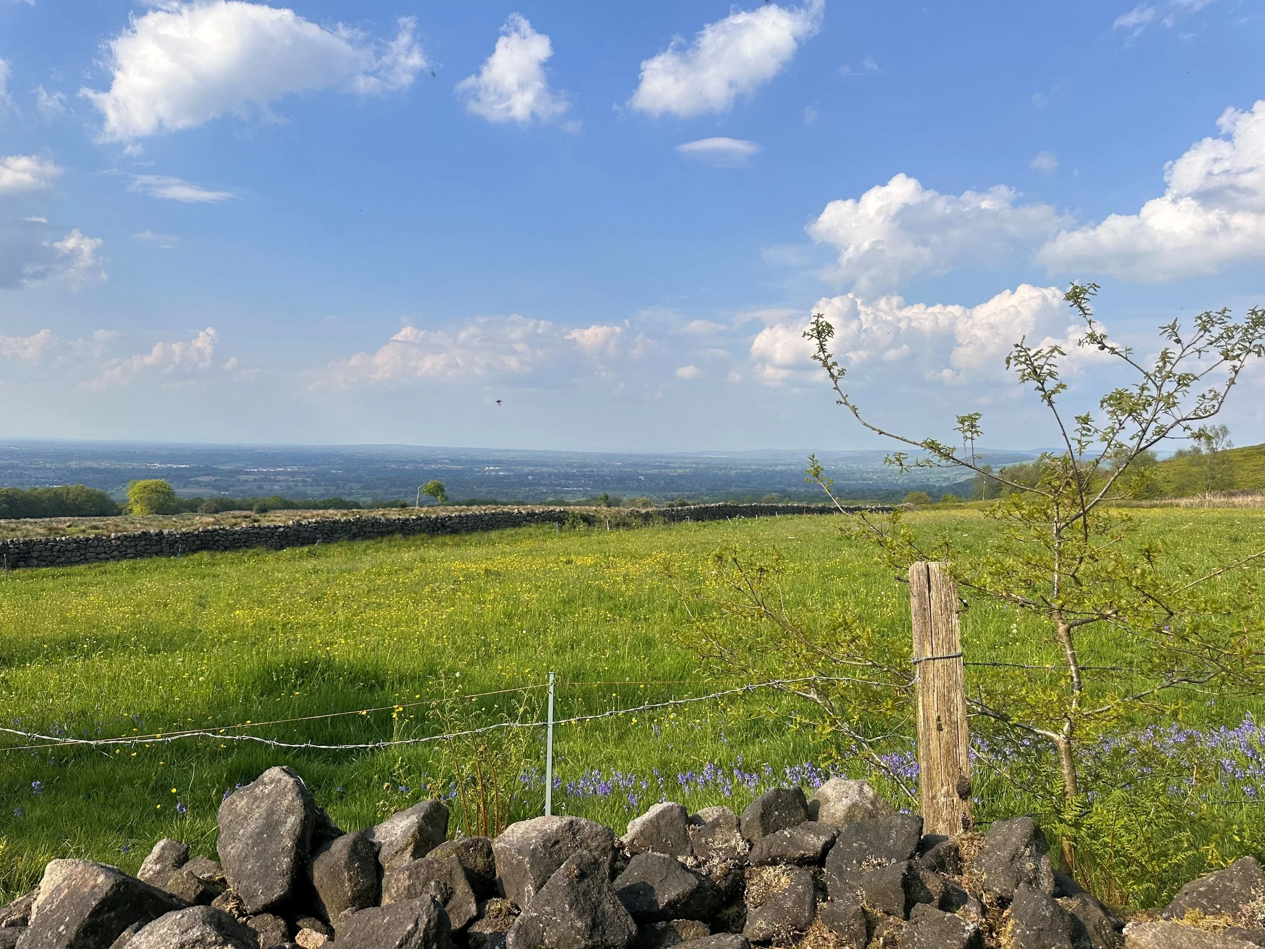
Good to Knows:
Terrain: The route is relatively flat with an uphill section shortly after The Rising Sun. A great excuse for carb loading at the pub.
The Rising Sun Pub: A stone’s throw away from Rode Hall & Gardens and Mow Cop Castle in Scholar Green, found north of Stoke-on-Trent. You’ll pass this cosy pub at the latter end of your walk, where you can expect home cooked food and a warm greeting aplenty.
Accessibility: Undulating terrain that may be unsuitable for buggies and wheelchair users. Please also note that there are no toilet facilities in and around the Mow Cop area.
Dog friendly: This route is dog-friendly, featuring just one stile with room for a dog to pass under, or small dog to be carried over.


WILD BANK TRIG AND SWINESHAW RESERVOIRS WALK
A taste of heather moorland as you climb to the local trig-point, with wide views over Manchester.

Overview: A longer walk featuring a scenic valley and a stiff climb to a fine moorland viewpoint.
Start: Carrbrook, SK15 3PH
Distance: 7.69 miles
Duration: 3 hours
Elevation: 1,550 feet
Difficulty: Moderate
Navigation: Follow step-by-step on komoot, or download GPX file

Route Highlights:
Swineshaw Reservoir: A great pitstop early on in the route, where you can rest up and enjoy the view shortly after the climb up from Carrbrook. Swineshaw Reservoir was one of three reservoirs proposed by the Glossop Commissioners, it was adapted in 1864 by the Glossop Water Company to provide drinking water for Glossop and taken over by the Glossop Corporation Waterworks in 1929 and then the Manchester Corporation Waterworks in 1959. It is no longer in service.
Wild Bank Trig: Your walk includes a climb to the Wild Bank Trig point, offering panoramic views over Manchester, Winter Hill, the Peak District and the Cheshire Plain. It's a fantastic spot to soak in the vastness of the landscape and grab some photos before heading back down to Carrbrook.
Swallows Wood: A lovely spot to shade-seek on a sunny day. This route only briefly passes through the woodland, but you can easily extend the route to have a good explore of the area.
Walkerwood: On the home stretch, you’ll pass through Walkerwood Reservoir. The wooded area surrounding is another great pitstop before you make your way back to Carrbrook.

Good to Knows:
Terrain: The terrain varies from moorland paths to wooded areas, so sturdy footwear is recommended. Some parts of the route are quite steep, so be prepared for uphill climbs.
Weather: Check the weather forecast before setting out as the moorland can be exposed to the elements. Dress appropriately and bring waterproofs if rain is expected.

Public transport options from Manchester:
If you're traveling from Manchester, here are some public transport options to reach Carrbrook:
Bus: Take the 343 bus from Manchester Piccadilly Gardens to Carrbrook, which operates regularly throughout the day. The journey takes approximately 45 minutes.
Train and Bus Combo: Alternatively, take a train from Manchester Victoria to Stalybridge (9 mins), then catch the 343 bus to Carrbrook (20 mins).
Driving: If you prefer to drive, Carrbrook is around a 30-minute drive from Manchester city center. Limited street parking available near the starting point.
UPHILL CHALLENGES:


WALKS WITH WATERFALLS:


