ALL TRAILS

A scenic circular walk to Cautley Spout (the highest waterfall in England)
A wild walk in Yorkshire: don’t miss this thrilling Howgills lollipop loop to England’s highest waterfall

Start: Layby near The Cross Keys Temperance Inn, Sedbergh (what3words: maybe.beaks.redouble)
Distance: 5 miles
Duration: 2-3 hours
Elevation: 1,600 feet
Difficulty: Moderate
Navigation: Follow step-by-step on komoot, or download GPX file
About the route
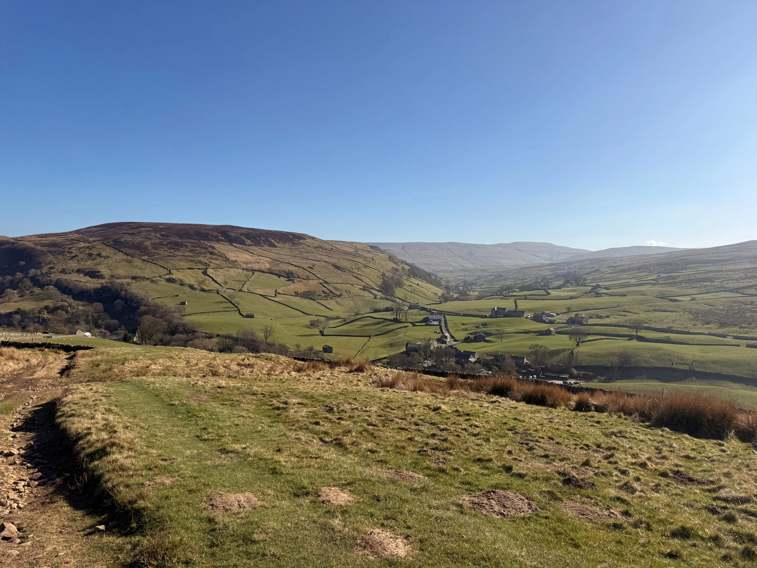
Tucked into the folds of the Howgill Fells, this satisfying lollipop route climbs from Sedbergh’s fringe to Bowderdale Head and loops around England’s highest above-ground waterfall: Cautley Spout. Starting from the 500-year-old Cross Keys Temperance Inn, you’ll enjoy gentle beginnings, a moderate high-fell climb, and a dramatic waterfall finale.
A path of contrasts, think pastoral lowlands, broad fells, and steep-sided valleys - this is one of the best routes to get a taste of the dramatic Howgill scenery without big scrambles or crowds.
Route difficulty
This is a moderate walk suitable for hillwalkers with a basic level of fitness. The loop section includes some steeper ground, exposed felltops, and one boggy stretch above the waterfall.
Walk type: Moderate
Terrain: Pasture, fell paths, rocky sections near waterfall, occasional bog
Accessibility: Not suitable for wheelchairs or pushchairs
Dog-friendly: Yes, on leads (sheep country!)

Why you’ll love this walk
England’s highest waterfall (200m tiered cascade)
Start and finish at a stunning heritage tearoom
Sweeping views from Bowderdale Head
Varied terrain: meadows, fells, ravines
Route highlights
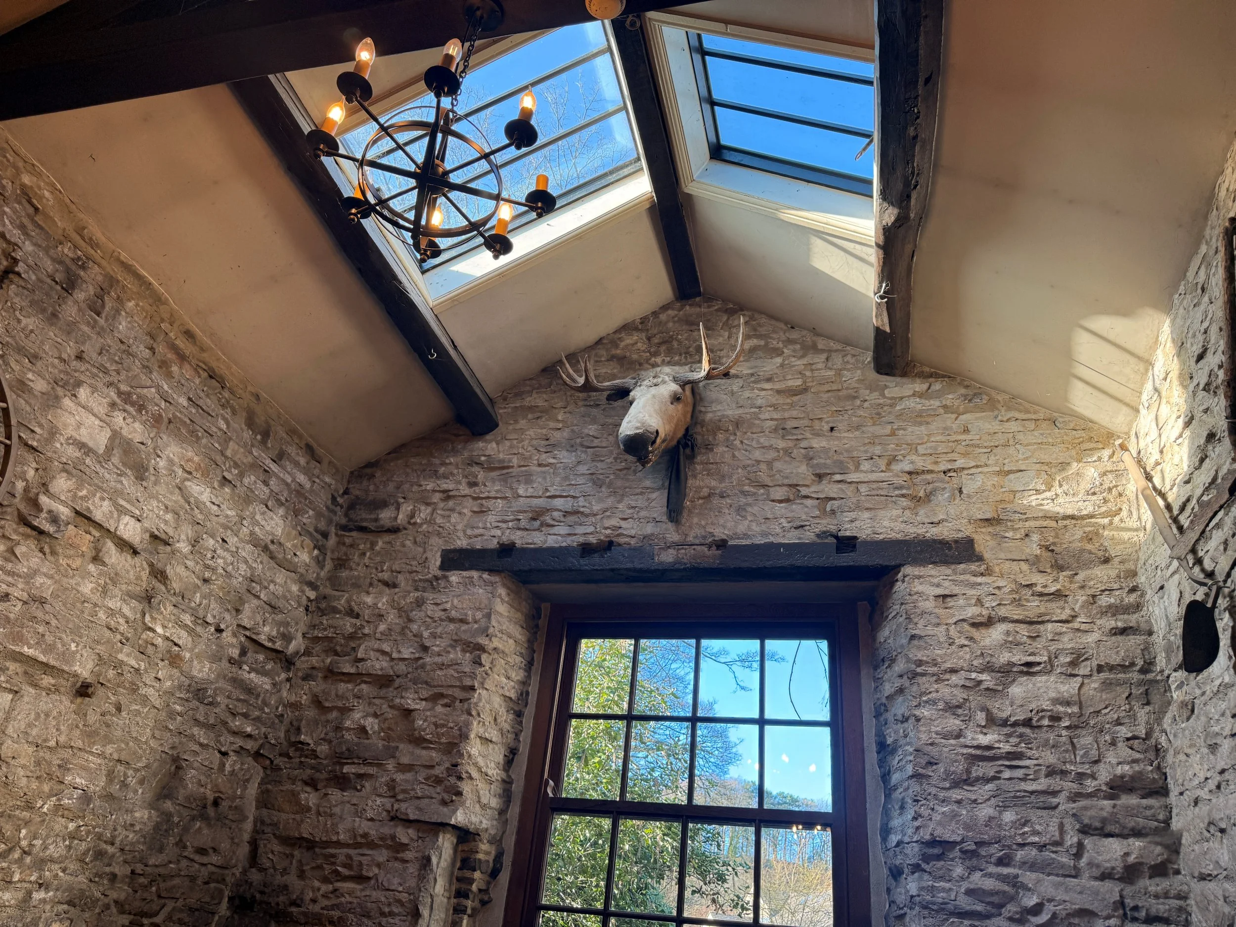
The Cross Keys Temperance Inn Begin with tea and homemade cake at this historic National Trust inn. It’s one of the oldest temperance inns in England — no alcohol, just charm and good food.
Bowderdale Head Reach the high point of the route with views across the Howgill Fells. Wild, expansive, and surprisingly quiet.
Cautley Spout The showstopper: a dramatic, multi-step waterfall plunging nearly 200m into the valley below. Best viewed after rain, and photo-perfect with long exposure.

Things to do nearby
Sedbergh: England’s official Book Town — indie bookshops galore
Farfield Mill: Heritage craft centre with art and textile exhibits
River Rawthey: Ideal for a post-walk paddle or picnic
Getting to the starting point
By car: From Sedbergh, take the road north toward Cautley. Just past The Cross Keys Temperance Inn, you’ll find a small lay-by for parking (limited spaces, arrive early).
By public transport: Catch a train to Oxenholme, then take a Western Dales Bus (S1T, S1W, S5 or S6 depending on the day) to Sedbergh. On select days (Tues, Thurs, Fri), you can continue on the S5/S6 to the Cross Keys lay-by.
OS Grid Ref: SD 698 969 What3words: (what3words: maybe.beaks.redouble)

Following the route
I use komoot and OS Maps for offline navigation. To follow the full route step-by-step on komoot, click this link here or download the GPX file and upload it to your preferred app.
How to extend your adventure
Continue beyond Bowderdale Head for a full Howgill traverse
Detour east to Aygill Force waterfall
Explore more of the Rawthey Valley on a return loop
Is this walk suitable for beginners?
This is a good step-up for walkers used to lower-level rambles. There are some steep sections, but no scrambling. If you’re building confidence with fell walks, this one ticks all the right boxes.
When’s the best time to do this walk?
Late spring to early autumn (April to September) is ideal. May and June give lush greenery and good waterfall flow. Winter can be icy and boggy.

Good to knows
No toilets at the start (use the pub before or after)
Mobile signal fades on the fells — download offline maps
Waterproof boots essential after rain
Limited parking, especially at weekends
Paths are not always waymarked — GPX or Komoot recommended
Dragon’s Ascent Challenge: Hike from England’s tallest waterfall to the UK’s highest pub
15 miles of remote moorland, Yorkshire charm, and big-sky views—this epic point-to-point challenge connects two legendary pubs via the mighty Great Shunner Fell and the spectacular Swaledale.

The Dragon’s Ascent at a glance
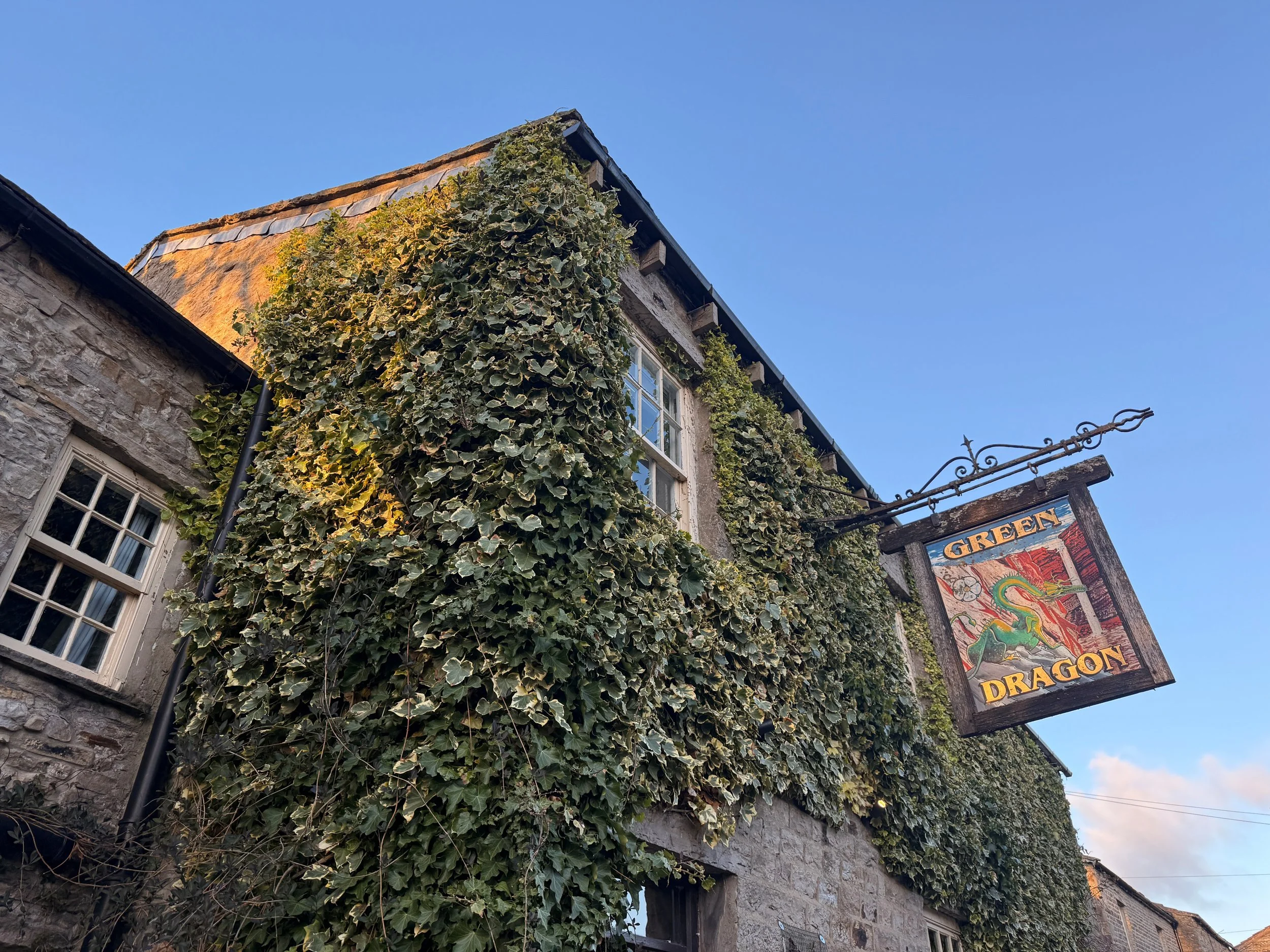
Start: Green Dragon Inn, Hardraw
End: Tan Hill Inn, Richmond
Distance: 15 miles / 25km
Elevation: 3,460 ft / 700m (Great Shunner Fell = 716m)
Time: 4–7 hours
Difficulty: Moderate to challenging
Dog Friendly: Yes – on lead around livestock & cliffs
Well-waymarked? Yes by the Pennine Way + Bridleway
Navigation: Follow on komoot or download GPX file
What is the Dragon’s Ascent Challenge?
The Dragon’s Ascent Challenge is a long-distance route through the Yorkshire Dales National Park, connecting the Green Dragon Inn in Hardraw with the Tan Hill Inn, the highest pub in Britain. Along the way, you'll:
Pass Hardraw Force, England’s tallest single-drop waterfall
Summit the mighty Great Shunner Fell
Wander through Swaledale, one of Yorkshire’s most scenic valleys
Stop for tea in the idyllic village of Thwaite
Catch a glimpse of the iconic Buttertubs Pass
Finish at the famously remote Tan Hill Inn
You can walk or run the route independently like we did, or sign up for the official annual event.

About the route
Starting in the pretty village of Hardraw, the path follows the Pennine Way and later the Pennine Bridleway, offering consistently easy-to-follow navigation and incredible variety—think limestone paths, open fells, deep valleys, and traditional Yorkshire villages. The 15.5-mile trail is a satisfying mix of terrain—from steady climbs and stone paths to open moor and riverside track. Most of the route follows the Pennine Way, making navigation easy. You'll ascend Great Shunner Fell, pass through the picturesque village of Thwaite, wind through Swaledale, skirt Buttertubs Pass, and finally reach the wilds around Tan Hill.
It’s long, scenic, and surprisingly varied, with plenty of spots to rest, eat, or detour.
Highlights include:
– A visit to Hardraw Force, England’s tallest single-drop waterfall
– A steady climb to Great Shunner Fell (716m)
– Homemade scones at Kearton Tearooms in Thwaite
– A moody stretch of wild moorland leading to Tan Hill
– Pint and pie at the finish line!
Why you'll love this walk
Wild and beautiful: From rolling meadows to rugged fells, the Dales never disappoint.
Pub-to-pub adventure: Start and end your day with real Yorkshire charm.
A true challenge: Feels like an achievement without being overwhelming or too strenuous.
Tea and cake halfway: Perfect motivation to reach Thwaite’s Kearton Tearooms.
Waterfalls, wildlife, and wow-moments: There’s always something breathtaking to look at along the way (if visibility is on your side, of course).

🧭 Route difficulty
Walk type: Moderate to challenging – the distance and elevation make it a solid day out, but the route is mostly on clear, non-technical paths.
Terrain: Moorland, flagstone paths, boggy sections (especially around Shunner Fell), and grassy trails. Rocky section near Swaledale.
Time needed: 4–6 hours moving time, 7+ with stops.
Navigation: Easy in good weather—just follow the Pennine Way and Bridleway signs. Bring a paper map and download GPX file. Useful for the moorland around Shunner Fell and near Tan Hill if visibility is poor.
Fitness level: Reasonable fitness, especially if aiming to complete in 4–5 hours.
Route overview
1. Start at Green Dragon Inn + Visit Hardraw Force
📍 Hardraw, Wensleydale
Before heading off, pay a quick visit to Hardraw Force, England’s highest single-drop waterfall (100 feet), accessible via the Green Dragon pub garden.
🎟️ Entry fee applies – bring a couple of pounds.
2. Climb to Great Shunner Fell (4 miles in)
Gradual but persistent climb to the summit of Great Shunner Fell—the third highest in the Dales. A stone wind shelter greets you at the top, along with sweeping views toward the Moors and Lake District on a clear day.
🥾 Conditions: Often boggy year-round – gaiters recommended.
3. Descend to Thwaite (~8 miles)
The descent to Thwaite is gentle and scenic, winding into the heart of Swaledale. Stop at the charming Kearton Tearooms for tea and cake—or a light lunch.
🍰 Kearton Tearooms: Open March–Oct, indoor + outdoor seating.
4. Around Kisdon Hill + optional Keld detour
Head north toward Keld, where you'll pass through lush green valleys, hidden waterfalls, and the River Swale. Take a 10-minute detour for Kisdon Force—it’s totally worth it.
5. Wild moorlands + final ascent to Tan Hill
Climb gradually across remote open moors. This stretch is exposed, with little shelter or signage. Keep eyes peeled for Pennine Way markers. Eventually, you’ll spot the Tan Hill Inn seemingly appearing from nowhere. A very welcome sight after 15+ miles.
🧭 Tip: In fog or snow, navigation here is trickier—use GPS or OS Map OL30.
🏁 Finish at Tan Hill Inn (the highest pub in the UK)
The highest pub in Britain (1,732 feet), the Tan Hill Inn is a classic stop for weary adventurers. Expect hearty food, a roaring fire, and proper Yorkshire hospitality. They also offer rooms if you want to stay over after your challenge.

How Long Does the Dragon’s Ascent challenge take?
The full 15-mile route typically takes between 4 to 7 hours to complete, depending on your pace, weather conditions, and how often you stop. Here’s a rough breakdown to help you plan:
Pace Estimated time
Trail runners: 2-4 hours
Fast hikers: 4-5 hours
Moderate walkers 5–6 hours
Casual pace with stops: 7+ hours
🥾 Our experience: We completed it in around 5-6 hours moving time at a relatively leisurely pace, with 7 hours total including a tea stop in Thwaite and a slight detour exploring the waterfalls near Keld. I’d definitely leave yourself at least 7 hours so you can enjoy the pitstops along the way.
Things that can affect timing:
Weather: Heavy rain, wind, or fog can slow you down—especially across the moorlands.
Terrain: Parts of the path can be boggy, particularly near Great Shunner Fell.
Stops: Waterfalls, tearooms, photo ops—there are plenty of tempting reasons to pause!
🔄 If you’re doing the challenge as part of an overnight pub-to-pub stay, there’s no need to rush—soak it all in and enjoy the journey.

Logistics & transport tips
🚗 Getting there
Start: Park at the Green Dragon Inn (Hardraw, DL8 3LZ)
End: Tan Hill Inn has a car park if you're arranging a pick-up or shuttle.
🚌 Return Options: This is a one-way route. You can:
Pre-arrange a taxi from Tan Hill back to Hardraw (recommended)
Do it as a there-and-back over two days, staying at each pub
Walk with a friend and leave one car at each end
Navigation
The path follows well-signed Pennine Way and Bridleway tracks. Still, it’s smart to carry:
What to pack
Waterproof boots or trail shoes
Waterproof jacket + layers
OS Map OL30 or digital GPX
Power bank
First aid kit
Water + high-energy snacks
Phone + offline route app (Komoot/OS Maps)
Trekking poles (optional for descent)
❓ Frequently asked questions
Can I do the walk in reverse?
Yes, but it’s more fun to finish at Tan Hill with a celebratory drink!
Is it dog-friendly?
Yes, but dogs should be kept on leads—there’s livestock, cliffs, and boggy moorland.
Do I need to train?
It’s not technical, but 15+ miles of hills can be tiring. Try a few 10–12 mile walks first.
Can I do it solo?
Absolutely. But let someone know your plans, especially in winter conditions.

When to do the challenge
Spring–Autumn (April to October) is ideal for good light and conditions.
Summer brings wildflowers to Swaledale and longer days.
Winter is possible but requires prep—some sections become boggy or icy, and moorland visibility can vanish quickly.
Weather tip: Conditions can shift fast on the fells—always bring layers, waterproofs, and a map/GPS device.
Join the official challenge
Held annually, walkers and runners gather to complete the route as part of the Dragon’s Ascent Challenge event:
Supported by trained safety & medical staff
Proceeds go to local Yorkshire charities
Sign up solo or with friends
Accommodation + meals available at start and end

🛏️ Stay the Night
Start: Green Dragon Inn, Hardraw – cosy rooms + waterfall access
Midpoint (Optional): Kearton Country Hotel, Thwaite
Finish: Tan Hill Inn – famously remote, full of character, great food
🍰 Food & Drink
Hardraw: Food + drinks at Green Dragon
Thwaite: Kearton Tearooms for lunch or cake
Keld: Keld Green Café (seasonal)
Tan Hill: Pub meals, snacks, and accommodation
🐾 Dog Friendly?
Yes – but keep dogs on leads near livestock and waterfalls. Some boggy sections might be tricky for smaller pups.

✔️ Good to knows
Difficulty:
Moderate – A long-distance walk with a steady climb up Great Shunner Fell in the first half and some remote, boggy terrain later on. Manageable for most walkers with a good level of fitness.
Footwear:
Sturdy, waterproof walking boots are highly recommended, especially after rain. The path can be boggy and uneven in places, particularly on the ascent to Shunner Fell and across the open moorland.
Dog-friendly:
Dog friendly (on leads). Dogs are welcome along the route but should be kept on leads around livestock and moorland nesting birds. There are streams en route, but it’s worth packing extra water for your pup.
Facilities:
There are toilets and food available at both pubs (start and end), and a tearoom close to midway in Thwaite. Be prepared with essentials and time your rest stops well.
Food & drink:
The Green Dragon Inn (Hardraw) – Pre-walk breakfast or coffee, and a quick visit to Hardraw Force behind the pub.
Kearton Tearooms (Thwaite) – A perfect halfway point with light lunches, tea, and sweet treats.
Tan Hill Inn – Your endpoint! Great for a hot meal and well-earned pint. Accommodation also available.
Optional detour to Keld Green Cafe for extra refreshments.
🧭 Following the route
I use komoot and OS Maps for offline navigation. To follow the full walk step-by-step on komoot, simply click this link here or download the GPX file and upload it to your chosen app, such as OS Maps.


BLEAKLOW HEAD, B29 CRASH SITE AND LOWER SHELF STONES LOOP
A slightly more challening walk with incredible views across the Peak District moors

Start: Old Glossop, SK13 7RP
Distance: 9.4 miles
Duration: 4-4.5 hours
Elevation: 1,700 feet
Difficulty: Moderate
Navigation: Follow step-by-step on komoot, or download GPX file
About the route
If you like your walks to come with unreal views and plenty of trig bagging for good measure, this one’s for you. Starting and ending at a cracking pub in Old Glossop, this route takes you up to the popular B29 Crash Site before meandering to Higher Shelf Stones where you can catch a cracking sunset. This is a very popular area for hiking, wild camping, and running, so you'll likely encounter other people while exploring. Although, we visited on a Friday and didn’t bump into another soul for miles around. With most of the route taking you across the moors, this is a great place to visit during heather season.
On the return leg you’ll find a great wild camping spot, perfect for if you plan to extend the route and catch a sunrise the next day. Just remember to arrive late, leave early, and as always, leave no trace.
Route Highlights:
B-29 Superfortress Crash Site
On 3rd November 1948, a Boeing B-29 Superfortress (American bomber) called Overexposed crashed into the Peak District moorlands, near Higher Shelf Stones on Bleaklow. Part of the 16th Photographic Reconnaissance Squadron, used for military photography, the plane crashed due to a fatal navigation error in poor visibility. All thirteen crew members sadly lost their lives.
A tragic incident, but remarkable to see the remains left atop the moorland. Much of the wreckage remains on the moors as a memorial and an official plaque has been erected.
Bleaklow Head
This rugged moorland plateau offers a real sense of solitude and breathtaking panoramic views. Standing at 2,077 feet, Bleaklow is one of three summits on this plateau and is marked by a huge cairn. Expect incredible views over the peat bog and gritstone landscape, some of the best in the Peak District.
Torside Clough
A brilliant place for a proper scramble. You don’t need to scramble the clough along this route unless you wish, but it makes for a great addition if you wanted to turn this walk into an adventure. It’s best to scramble the clough rather than down, though!
The Wain Stones
The Wain Stones are a distinctive rock outcrop popular with walkers and climbers. The path here can get quite boggy and difficult to navigate in poor weather, so make sure you kit up and bring a map with you

Where is the B29 Crash Site?
This walk leads you to the B29 crash site from Old Glossop and also takes in Higher Shelf trig point. The crash site itself is a lonely and sombre place. Please be respectful, do not allow your children to climb or play on the wreckage and please do take all rubbish home with you.
Click here for the Google Maps location
Grid reference: SK 0909 9486
what3words: ///mouth.scarecrow.annual
Getting to the starting point
Public transport
Take the train from Manchester Piccadilly to Glossop (30 mins), then it’s just a short walk to the starting point. You can also get the train direct from Gorton, Fairfield, Guide Bridge, Flowery Field, Newton for Hyde, Godley, Hattersley, Broadbottom and Dinting.
Arriving by car
If you’re travelling by car, you’ll find plenty of on street parking in Old Glossop. We parked in the free car park at Manor Park (SK13 7RP).

✔️ Good to knows
Footwear: As with any walk in the glorious UK, sections of this route can get extremely boggy after heavy rainfall. Definitley boot up for this one, even if you’re visiting after a dry spell.
Food and drink: You’ll be spoilt for choice on places to refuel after your walk. Our favourite is the vegan selections on offer at The Globe. Cheap, incredibly tasty, and great atmosphere. A win-win.
Parking: If you’re travelling by car, you’ll find plenty of on street parking to choose from. We used the free car park at Manor Park (SK13 7RP).
Public transport: Travelling from Manchester? Take the train from Manchester Piccadilly to Glossop (30 mins), then it’s just a short walk to the starting point. You can also get the train direct from Gorton, Fairfield, Guide Bridge, Flowery Field, Newton for Hyde, Godley, Hattersley, Broadbottom and Dinting.
🧭 Following the route
I always use OS Maps and komoot for offline navigation. To follow this walk step-by-step on komoot, simply click this link here or download the GPX file and upload it to your chosen app, such as OS Maps.
⚠️ A word of warning
Only attempt this walk on a clear day. Many of the footpaths over the moor between the Pennine Way and Higher Shelf Stones are unclear and there are multiple options. It can be rather disorientating and in poor visibility it is very easy to get lost. The boggy tracks add to the difficulty, so make sure you download this route offline before visiting. It is also extremely exposed on this walk. On hot, sunny days there is no shade, in the winter months the temperature drops, and you can often experience four seasons in one day. Wear appropriate clothing, including sturdy footwear, and bring enough water.
While this hike doesn’t require technical ability, the weather can change quickly atop the moors. Be sure to take a compass, map and offline GPS system. Remember to pack a torch in case you find yourself enjoying the views and losing track of time.
After leaving Old Glossop, there are no facilities on this walk. Please bring all food and drink with you, and take all rubbish home with you.
Fancy giving this one ago? Check out our full guide on Instagram
More routes like this one:

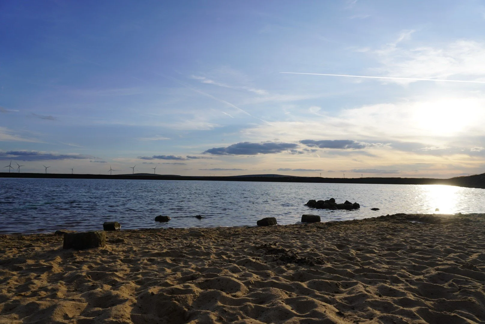
GADDINGS DAM LOOP (ENGLAND’S TALLEST BEACH)
This 5 mile walk in Todmorden truly has it all — cracking pubs, stunning views and a wild swimming spot to boot

Start: Todmorden Centre, OL14 5QA
Distance: 5.34 miles
Duration: 2-3 hours
Elevation: 975 feet
Difficulty: Easy—Moderate
Navigation: Follow step-by-step on komoot, or download GPX file
About the route
If you like your walks to come with plenty of cafes, pubs and a wild dipping spot mid-route, then this one’s for you. Starting and ending in the thriving market town of Todmorden, this is easily one of my favourite routes up north. Blessed with stunning scenery, magnificent architecture, diverse shops and a thriving art community, Todmorden is the perfect place for a short break or a walking holiday.

Route Highlights:
Todmorden
Known for its stunning Pennine landscape, rich industrial heritage, and a strong sense of community, Todmorden offers a blend of rural tranquility and urban convenience, with a variety of shops, restaurants, and local businesses. The town is also home to a number of historical landmarks, including the iconic Town Hall and the picturesque Rochdale Canal… alongside Stoodley Pike, which you can reach easily along this route. More on that, below.

Gaddings Dam
Gaddings Dam was built in 1833 mainly to supply water for the nearby inhabitants. During this period, there were huge areas of puddled clay in the area that came from a nonporous core which mostly comprised the whole dam itself. Slowly, the dam experienced a series of overhauls that made it look more modern and efficient for today’s time. One of its most significant changes came during 2001 when facilitators decided to drain all the natural water down due to poor conditions.
Fortunately, local groups and activists wanted to preserve it and it was eventually saved from closing. At that time, the dam was also tarnished due to weather increments that forced nearby coordinators to repair some of its facilities. Today, it’s one of the best wild swimming spots close to Manchester — and makes for a cracking day out when paired with this 5 mile walk.
Stoodley Pike
Looking to make a proper day of it? This walk can easily be extended to reach Stoodley Pike, where you’ll find a monument dominating the skyline. Sitting 1,300 feet atop the moors, Stoodley Pike Monument contains a spiral staircase of 39 steps, accessed from its north side, which take you to a viewing platform. If you visit, please be aware that several of the internal steps are in darkness, so it’s useful to have a torch to light your way, as there are no windows. The entrance to the balcony is on the Monument’s west face, some 40 feet above ground level. The views are well worth the walk and the climb!
As we were racing to beat the daylight we didn’t make it to the pike on this particular route, but it can easily be extended to include Stoodley Pike along this route. You won’t regret it.

Where is Gaddings Dam?
Gaddings Dam can be found in Todmorden, West Yorkshire, at the heap of a plateau that runs from Todmorden to Walsden. At 80 feet above sea level, it’s known as the highest beach in England. Aside from being popular for its panoramic views and hiking trails, it features sandy banks that makes it a peculiar but popular spot for wild swimming.
Swimming at Gaddings Dam
Swimming is allowed at Gaddings Dam. In fact, it’s one of the go-to wild swimming options in the UK and it has very few restrictions. Until recently, Gaddings Dam had been a well-kept secret for both locals and visitors alike for many years. The dam boasts breathtaking views, excellent hiking paths, a sandy beach perfect for lounging, and one of the top wild swimming areas in the county. It’s no surprise that Gaddings Dam is becoming increasingly popular. Its increasing popularity does mean the chances of you having the place to yourself are no longer likely. But choose your timings wisely, and you can still beat the crowds. We visited on a Saturday at sunset and had the place almost to ourselves.
Getting to Gaddings Dam starting point
Public transport
If you're heading to Todmorden by train, there are plenty of easy and direct routes you can take. Trains run regularly from Manchester Victoria, Leeds, or Bradford Interchange. Trains from Manchester Victoria take around 20 minutes, while those from Leeds take around 50 mins. If you're starting in Bradford Interchange, you'll find direct trains that also pass through Halifax and Hebden Bridge.
Arriving by car
If you’re travelling by car, you’ll find plenty of parking in Todmorden centre. Please try to avoid parking near Gaddings Dam as the area gets very congested and causes disruption to local residents. We parked in the free car park on Dale Street (OL14 5QA).
Visiting the Dam
The dam has no road access and can only be reached by foot on a half hour walk on either of two steep very rugged footpaths. Please choose your footwear appropriately.
There are no facilities for swimmers at the dam: no toilets, life guards, changing rooms or cafes.
Please park carefully and respectfully. There is very limited marking in and around the dam. Illegally parked cars have been towed away and parking tickets have been issued. I recommend visiting by train or parking in Todmorden and following our route up to the dam.
Follow the marked paths. Some visitors have created a direct track to the Dam, which is now very eroded and dangerous. There have been serious accidents, requiring fell rescue teams and ambulances. Please stick to the marked paths to keep yourselves and others safe.
If possible try to reach the dam on foot or on public transport. If not following our route, there is an hourly bus, the T6 or T8, from Todmorden bus station to the beginning of the footpaths, departing at 10 minutes past the hour.
Good to knows
Footwear: As with any walk in the glorious UK, sections of this route can get super boggy after heavy rainfall. Definitley boot up for this one unless you’re visiting after a dry spell.
Food and drink: You’ll be spoilt for choice on places to stop on this route. You’ll pass two pubs mid-route and find an abundance at the starting point in Todmorden — alongside plenty of cosy cafes and stunning independent shops.
Parking: If you’re travelling by car, you’ll find plenty of car parks in Todmorden to choose from. We used the free car park on Dale Street (OL14 5QA).
Public transport: Travelling from Manchester? You’ve hit the jackpot with this route: you can reach the starting point via train in 20 mins from Manchester Victoria. Easily one of my favourite public transport walks close to Manchester.
Following the route: I always use OS Maps and komoot for offline navigation. To follow this walk step-by-step on komoot, simply click this link here or download the GPX file and upload it to your chosen app, such as OS Maps.

LUD’S CHURCH & THREE SHIRES HEAD LOOP
A 6 mile circular through an enchanted chasm with a cafe pitstop midway

Start: Gradbach Car Park, SK17 0SU
Distance: 6.21 miles
Duration: 2-3 hours
Elevation: 825 feet
Difficulty: Easy—Moderate
Navigation: Follow step-by-step on komoot, or download GPX file
About the route
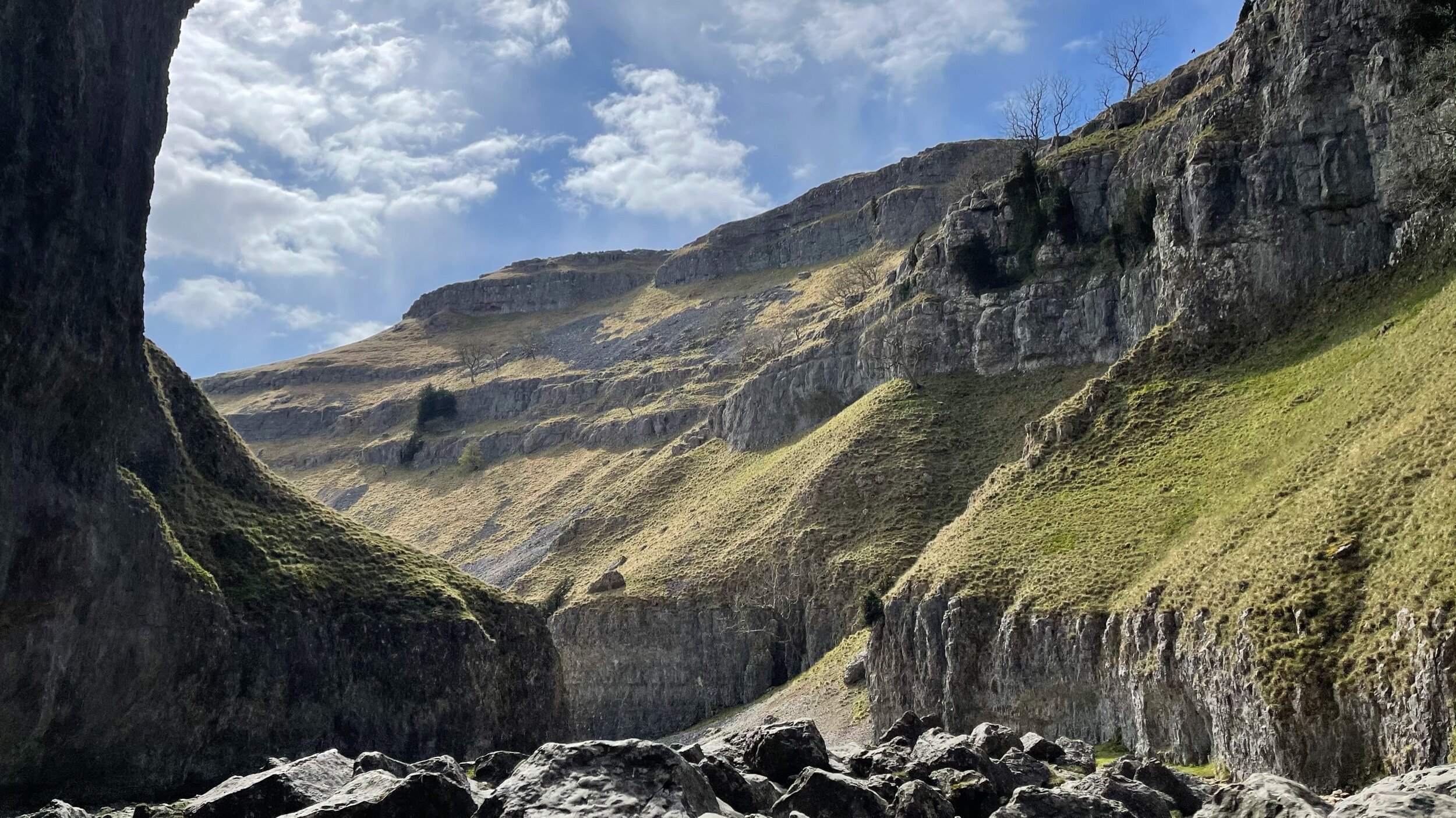
If you love the Peak District as much as I do, no doubt you’ve heard of two of its most loved beauty spots — Three Shires Head and Lud’s Church.
But did you know you can visit them both in one walk? I didn’t, until I mapped out this 6 mile route that starts in Gradbach and realised you can easily extend the Lud’s route to include Three Shires Head. This does mean you have to pass the starting point on the return leg to Three Shires which, usually, is a no from me. But after the refreshing dip up at the waterfall, it was more than worth it.

Route Highlights:
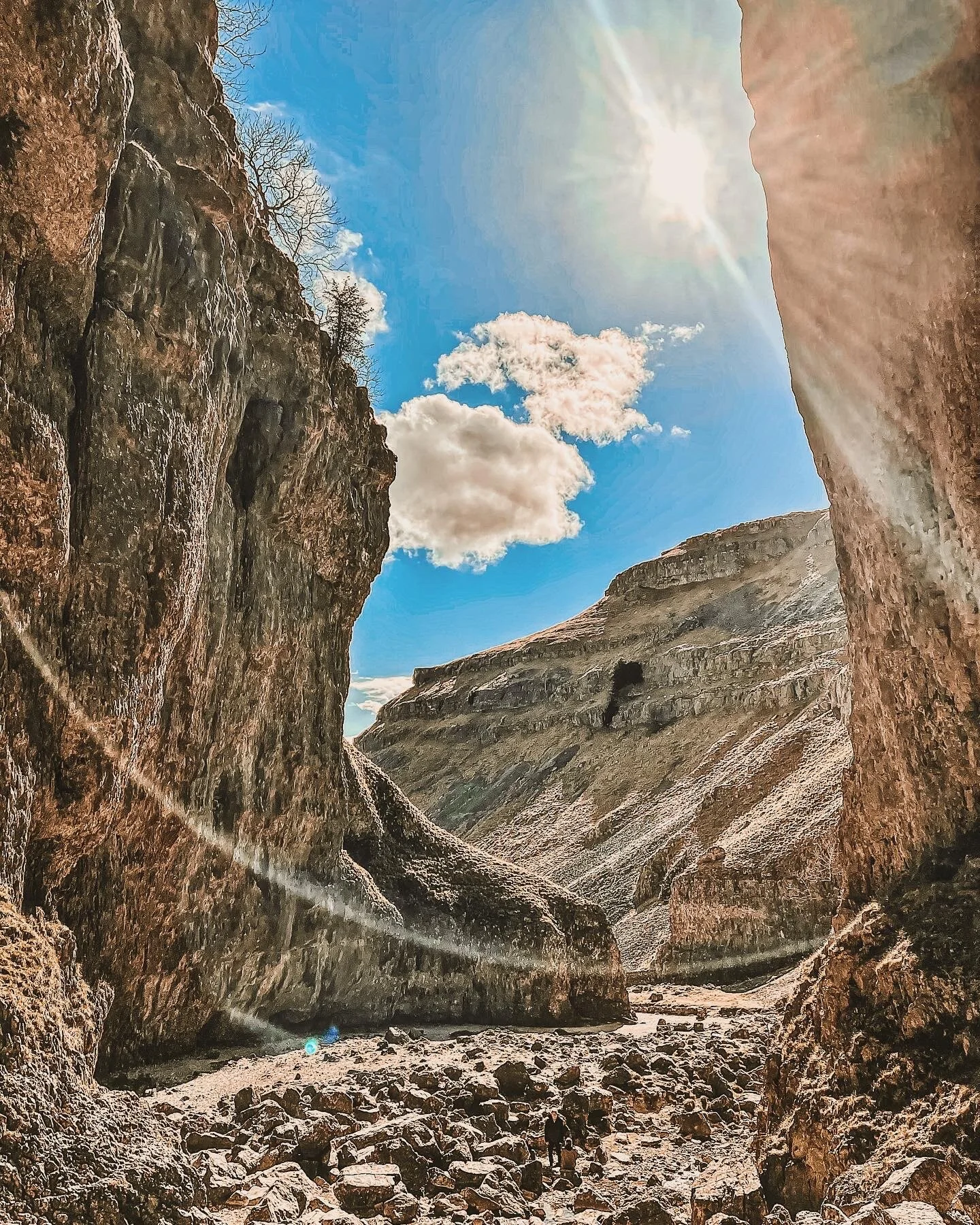
Lud’s Church
This mystical chasm is hidden in the woodland known as the Black Forest and is thought to have been a sacred place to Pagan worshippers. Apparently only on Midsummer’s Day does the sun penetrate the deep chasm, meaning it’s cool, damp and dark for the rest of the year. It was also used as a secret place of worship by the Lollards, who were persecuted during the 15th Century for their beliefs.
The ravine that makes up Lud’s Church is thought to have formed during the post-glacial period —some 11,000 years ago by a large slip of Roaches Grit, a coarse form of sandstone. It wasn’t until the 15th century that this place became a popular place to dwell— among a secret community, at least. A group of religious dissenters called the Lollards flocked here to hold covert religious meetings to escape the prosecution of the Catholic Church. It’s thought the name of a man arrested at one of these meetings, Walter de Ludank, inspired the name of the site.
Over the centuries, this magical spot has been associated with tales of Robin Hood and his Merry Men, who’re thought to have hid here as a place of refuge. Today, the area provides a dramatic nature walk through the Black Forest, transporting passers-by into old England and its many forgotten tales. You certainly don’t have to stretch your imagination too much to picture this place as the origin of many myths and mysteries.
Lud’s Church is a popular Peak District gem, but is it worth the hype?
In my opinion, absolutely. Walking between the towering gorge walls of Lud’s Church feels like you’ve strayed onto the set of Jurassic Park. The walls of the chasm are dripping in moss and there are many narrow passages to explore. You’ll also be struck by the silence, which only adds to the mysterious atmosphere. It’s easily one of the most magical places to explore in the Peak District, and one of the reasons I keep going back.

Three Shires Head
Three Shires Head is where the counties of Derbyshire, Cheshire and Staffordshire meet at a waterfall and collection of pools on the River Dane. It’s a stunning spot and a favourite Peak District wild swimming location. Even on a cloudy day it’s perfect for a picnic and paddle; kids will spend ages walking over the boulders and dipping their toes into the icy cold waters. So if you’re looking for one of the best wild swimming spots in the Peak District, then Three Shires Head is the place to go.
Extending the route
Looking to make a proper day of it? Lud’s Church sits right by one of the best walks in the Peak District — The Roaches. The Roaches is a 505-metre high ridge that soars above Leek and Tittesworth Reservoir, making for incredible views on a clear day. Surrounding, there’s ample places to explore with lots of diversions for those wanting to spend the day discovering new paths. Check out our guide on The Roaches and Lud’s Church walk here.

Getting to Lud’s Church
Reaching Gradbach, the starting point of this Lud’s Church walk, is most convenient by car. We paid £5 for all day parking in an overflow car park situated close to Gradbach Mill.
Good to knows
Footwear: As with any walk in the glorious UK, sections of this route can get super boggy after heavy rainfall. Definitley boot up for this one unless you’re visiting after a dry spell.
Food and drink: You’ll pass Riverside Cafe at Gradbach Mill on your return from Lud’s Church up to Three Shires. Here you’ll find toilets and drinks, snacks and sweet treats aplenty.
Parking: Gradbach Car Park fills up quickly on weekends. We parked at an overspill car park on a nearby farm, which was £5 for the day.
Wild swimming: Three Shires Head is one of the more popular wild dipping spots in the Peak District. We timed the walk to arrive at Three Shires late evening on a weekend, and had the place almost to ourselves.

Fancy giving this one ago? Check out our full guide on Instagram
More routes like this one:

WESSENDEN VALLEY LOOP
This 6 mile walk in the Wessenden Valley is perfect to save for a summer’s afternoon, featuring a trig, a wild dipping spot, and unspoilt views as far as the eye can see

Start: Wessenden Head Road Car Park, HD9 4EU
Distance: 5.89 miles
Duration: 2.5 hours
Elevation: 750 feet
Difficulty: Easy—Moderate
Navigation: Follow step-by-step on komoot, or download GPX file
Route Highlights:
Route details
This Wessenden Valley walk explores the valley and visits some of the waterfalls before heading up to West Nab. At 500m above sea level it’s one of the higher peaks in the Peak District and has amazing views over the moors. On the return leg, you’ll tackle the steep climb up to Raven Rocks, then scramble your way round to West Nab. There is a path running through the rocks which leads up to West Nab.
West Nab is a mystical place which has a history steeped in folklore. There are curious rock formations, including the Druid Stone which has three round indentations in, said to be seats for 3 priests to watch the sunrise before conducting a ritual.
West Nab Trig
Looking for the best place near Holmfirth to catch a sunset? You can’t go wrong with West Nab Trig. West Nab is one of the easiest trigs to bag, with parking closeby. While our walk first takes you deep into the valley (meaning there’s an ascent to get back up to West Nab on the return leg), you could easily plan a trip to West Nab itself without having to tackle the climb.
West Nab is a bit of a hidden gem in the Peak District. Being at the northern boundary of the Peak District, it’s not very well known, but a quick climb up the hill gives you incredible views over Huddersfield, Holmfirth, over to Saddleworth, Manchester and beyond.
The area also has a spirtual past. One of the largest rocks has three circular bowls and is thought to be the seat of three priests or druids. Whether this is true or not, it’s a beautiful and atmospheric place – well worth a visit. The area is designated as a Site of Special Scientific Interest and dogs are excluded. There is a sign on the stile warning you of this so if you are a dog owner, please skip out West Nab on the return leg.

Blakely Clough Waterfall
This beautiful waterfall is tucked away on the Pennine Way. The plunge pool is about 2m deep at the deepest spot, making it great for a mid-route wild dipping spot to cool off on a hot summer’s day.
Wessenden Valley
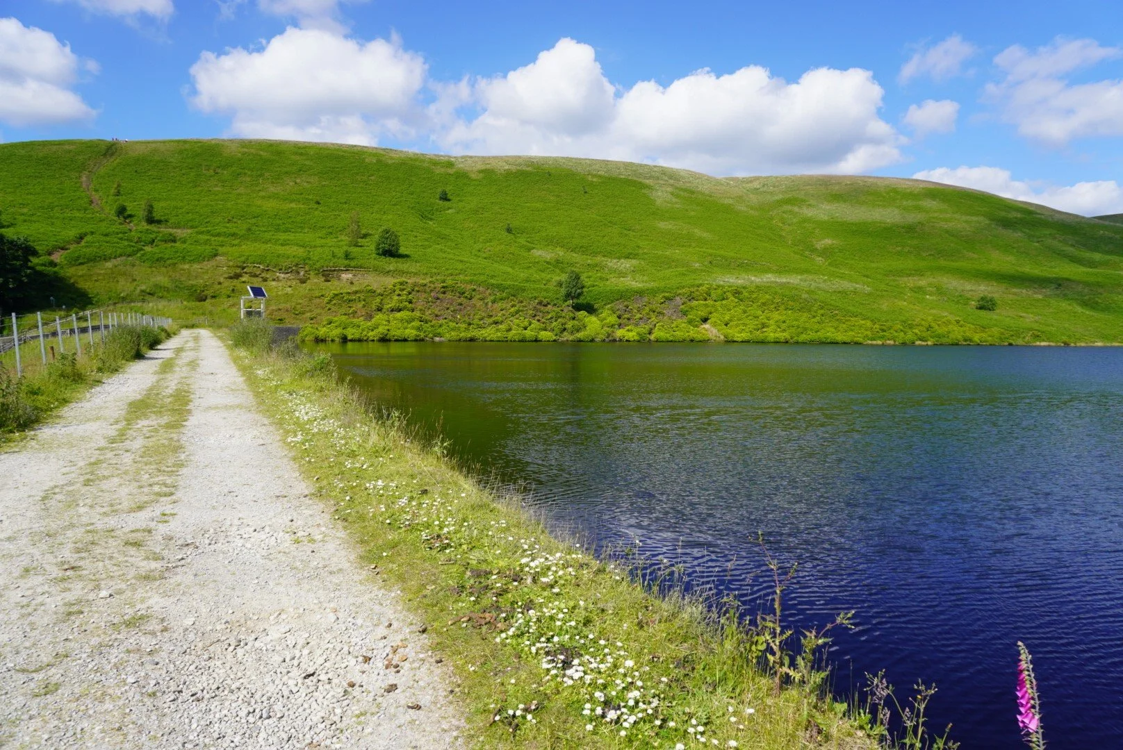
This circular walk over superb moorland starts up high from a parking area on Wessenden Head Road. The route drops gently across moorland with stunning views all the way to Deer Hill reservoir on the outskirts of Meltham. From here, a bridleway leads uphill to Wessenden Head Road, the first real climb on the walk. On a clear day the deer are out in the field and are a lovely sight.
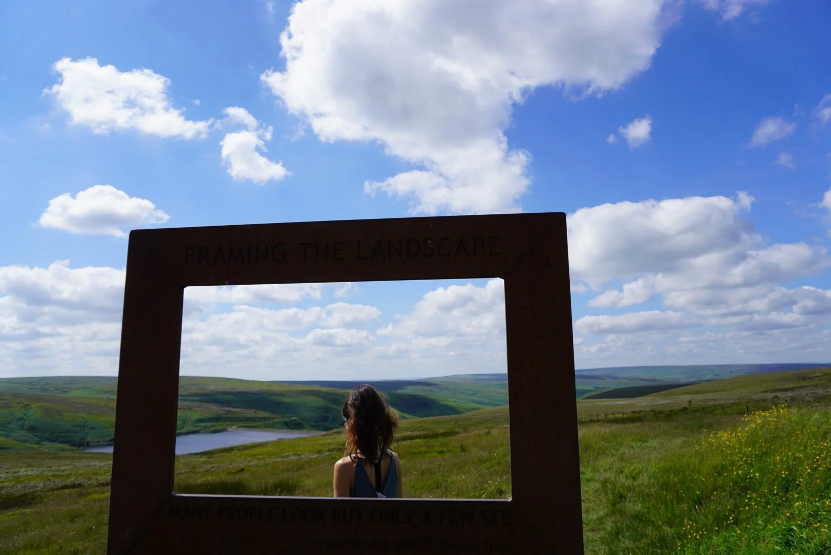
Framing the landscape
Easily accessed from the parking layby on Wassenden Head Road, this frame is one of a series of open air art installations by Ashley Jackson in partnership with the National Trust. There are six frames in total, with another located at Holme Moss car park. The views in this frame points towards Wassenden Head Reservoir and are simply stunning.

Getting to the Wessenden Valley
Reaching the Wessenden Valley is most convenient by car. This circular walk over superb moorland starts up high from a parking area on Wessenden Head Road. Driving time from Manchester is around 40 mins.
If you’re arriving by public transport, you can take the train to Greenfield then board the 352 bus from Stop D towards Wessenden Head Road. The bus stops a 5 min walk away from the starting point.
Good to knows
Hazards: With an absence of footpaths on the final stretch of the return leg, it's necessary to return to the parking area along the grass verges of Wessenden Head Road. Take care as cars travel at speed on this road.
Footwear: The area around West Nab Trig can get incredibly boggy after rainfall, so definitley boot up for this one if you’re including West Nab in the route.
Food and drink: There are no facilities along this route, but you’ll find plenty in nearby Holmfirth and Meltham. You’ll also find Snoopy's snack van on the A635 Holmfirth to Greenfield road at the junction with Wessenden Head Road. The Huntsman Inn and The Ford Inn are on the A635 towards Holmfirth. Shops, cafes and pubs available in both Meltham and Holmfirth.
Parking: We parked at the car park on Wessenden Head Road (free of charge). This is a small, rough car park with space for 8-10 cars, but there are also roadside spaces nearby.
Wild swimming: You’ll find a wild dipping spot around half way round at Blakely Clough Waterfall, perfect for cooling off on a hot summer’s day.


WATERFALL SWALLET, EYAM AND FOOLOW CIRCULAR WALK
This circular Peak District walk starts and ends at a pub, taking you to a hidden waterfall, before rounding off your day in the village of Eyam

Start: The Bulls Head, Foolow, S32 5QR
Distance: 6.26 miles
Duration: 2.5 hours
Elevation: 875 feet
Difficulty: Easy
Navigation: Follow step-by-step on komoot, or download GPX file
Route Highlights:
Waterfall Swallet
A virtually unknown gem along the side of an unassuming road between Foolow and Eyam, Waterfall Swallet is nestled in a cleft of limestone and largely hidden from view. The Waterfall Swallet means ‘a place where water breaks in on miners’. Once you reach the waterfall, the sound of cascading water drowns out any noise from nearby traffic, making you feel miles away from civilisation. The area offers several stones and logs perfect for sitting down and enjoying a picnic — an ideal pitstop as part of this longer walk.
Stoney Middleton Heritage Trail
The Heritage Trail Guide and Heritage Trail Map are available to download, or can be picked up from Bakewell Visitor Centre, the Moon Inn, and the Grove Gardens (in the village behind the chip shop). There are two trails which can be undertaken, separately or combined into one walk. The maps also provide information about the various points of interest around the trails. Alternatively you can take the trails using the information boards located at various points around the route; each board has a map to show where you are and where to go next, they also contain information on all the points of interest.
Our walk takes you along a small segment of the heritage trail but can easily be turned into its own adventure in and of itself.
Darlton Quarry
The Peak District is home to more mines and quarries than any other national park, reaching nearly 70 in total. We’re not sure what it is about abandoned quarries, but for us, they make great vantage points to sit and watch the world go by. And this one is of international fame! Tom Cruise was spotted filming here for Mission: Impossible Dead Reckoning in August 2021 for the scene involving the locomotive crash, which was followed by another stunt involving a train carriage.
Eyam, Plague Village
Nestled in the heart of Derbyshire, the village of Eyam is renowned for its extraordinary history and picturesque charm. Known as the ‘Plague Village’, Eyam made a remarkable sacrifice during the 1665 bubonic plague by voluntarily quarantining itself to prevent the spread of the disease. Today, visitors can explore its quaint stone cottages, the historic Eyam Hall, and the evocative plague markers that tell the story of the villagers' courage and resilience. Surrounded by the stunning landscapes of the Peak District, Eyam offers a unique blend of natural beauty and poignant history… and plenty of pubs and cafes, to boot!
Eyam Delph Nature Reserve
Eyam Delph Nature Reserve is a hidden gem in the heart of Derbyshire, England, known for its rich history, diverse wildlife, and picturesque landscapes. The nature reserve was originally a limestone quarry, providing valuable stone for construction in the local area. It has since been transformed into a nature reserve, offering a glimpse into the area's industrial past. Wild garlic is in full bloom here if you plan your visit between February—April when wild garlic is in peak season

Good to knows
Waterfall Swallet: It’s worth noting before you set off, this particular waterfall does require a decent amount of recent rainfall to flow. If you visit during a dry spell, you may be met with a damp cliff wall. I guess that’s one perk to visiting during a rainy period! We visited after a fair amount of rain and it was still only a light flow, so the more rain the better.
Finding the hidden waterfall: If you’re not feeling up to the full walk but want to visit the falls, you can easily make this a trip out on its own. To find the quickest route to Waterfall Swallet use the following coordinates: 53.2902792, -1.7032805, which will take you to a small lay-by with enough room for a couple of cars to pull fully off the road. You then need to head back down the road for 70m until you see a little gate on the right and some stone steps leading down into a wooded gorge. You can also use What3Words (‘sprinting.litters.wipe’), which will take you straight to the waterfall.
During our visit in autumn, the steps were almost entirely covered with leaf litter, and quite slippery. It’s steep and very uneven, but if you take it slowly it’s not as difficult as it looks to reach the clearing.
Please note, the access to the waterfall is unsuitable for anyone with mobility issues.
Eyam Hall Courtyard: The Courtyard Barn offers a selection of giftware, homeware, beer, wine and spirits in the beautiful setting of the old brewery barn in the corner of Eyam Hall Courtyard. We usually stop off in the main village when visiting Eyam but this time decided to take a trip to the courtyard, instead. And we’re so glad we did! A gorgeous place to stop off, have a brew, and browse the quaint pop ups — from second hand books, to crystals, plants, and more.


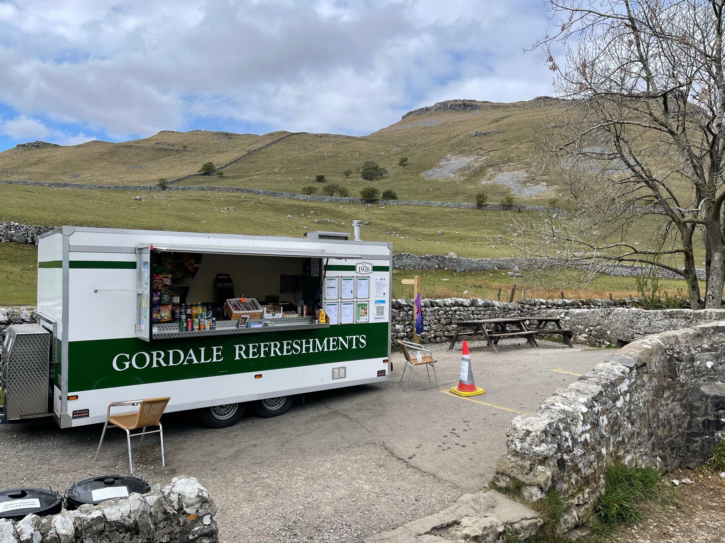
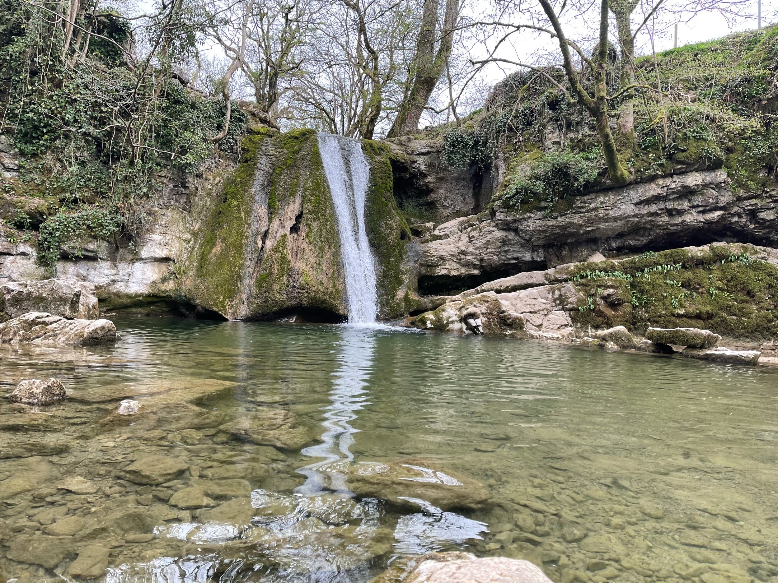
MALHAM COVE, SHIRE
A magical route through the Yorkshire Dales — waterfalls, fairytale caves and insane views throughout
Looking for best walk in the Yorkshire Dales? Look no further…
Distance: 8.32 miles
Time: 2-4 hours
Ascent: 900 feet
Start: National Park Centre, Malham
Navigation link: follow the trail here
Feel like you might’ve accidentally clicked the wrong link?
As much as these images feel like another country entirely, they’re still very much within driving distance to our rainy city! This trail truly has it all: not one, but two fairytale-esque waterfalls (Janet’s Foss and Gordale Scar), a hidden cave… and a cove that wouldn’t look out of place in Arizona… and a fairly flat route throughout!
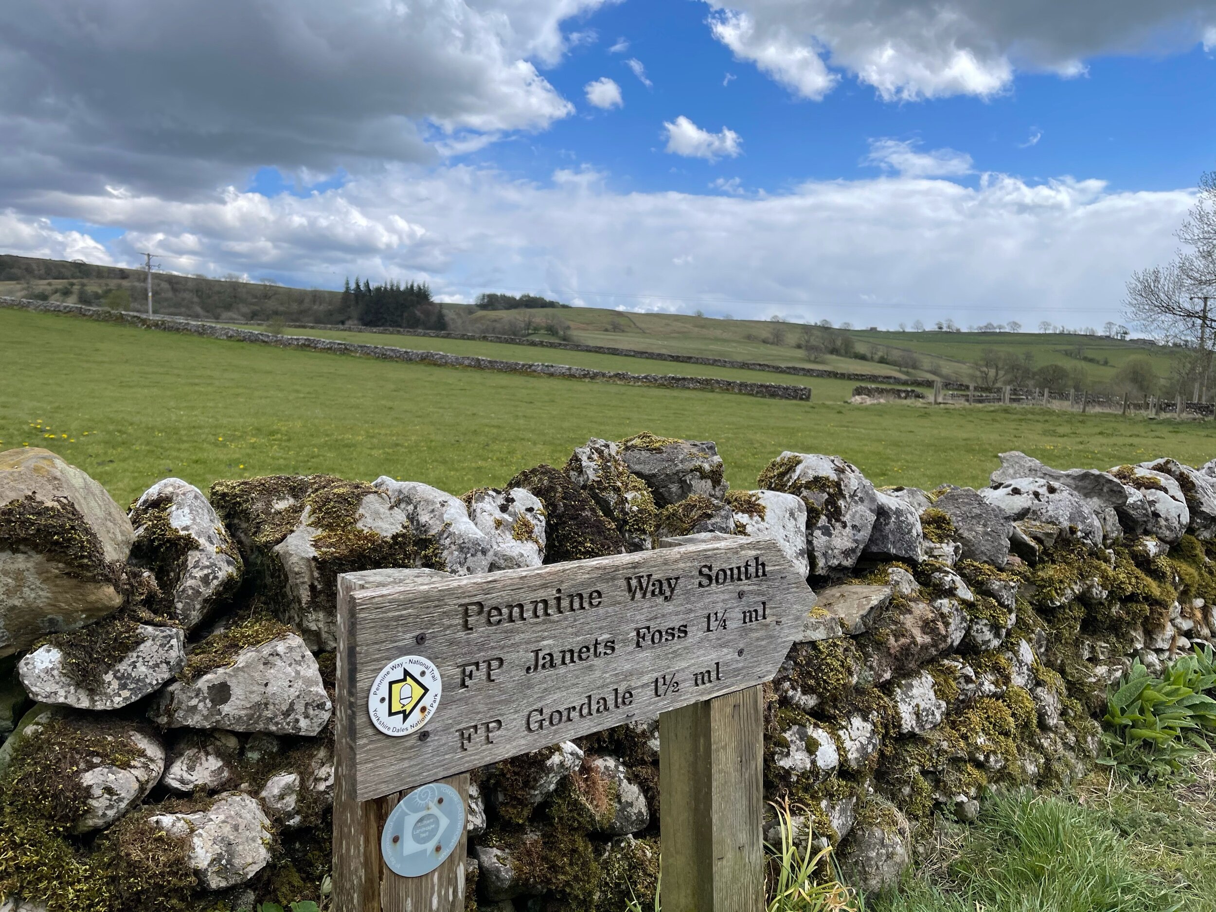
A magnet for families and ramblers alike, Malham, North Yorkshire is home to so many enchating places to explore — that said, it can get pretty busy in the summer months, so if you’re after a less populated stroll, we’d recommend popping down during the week.
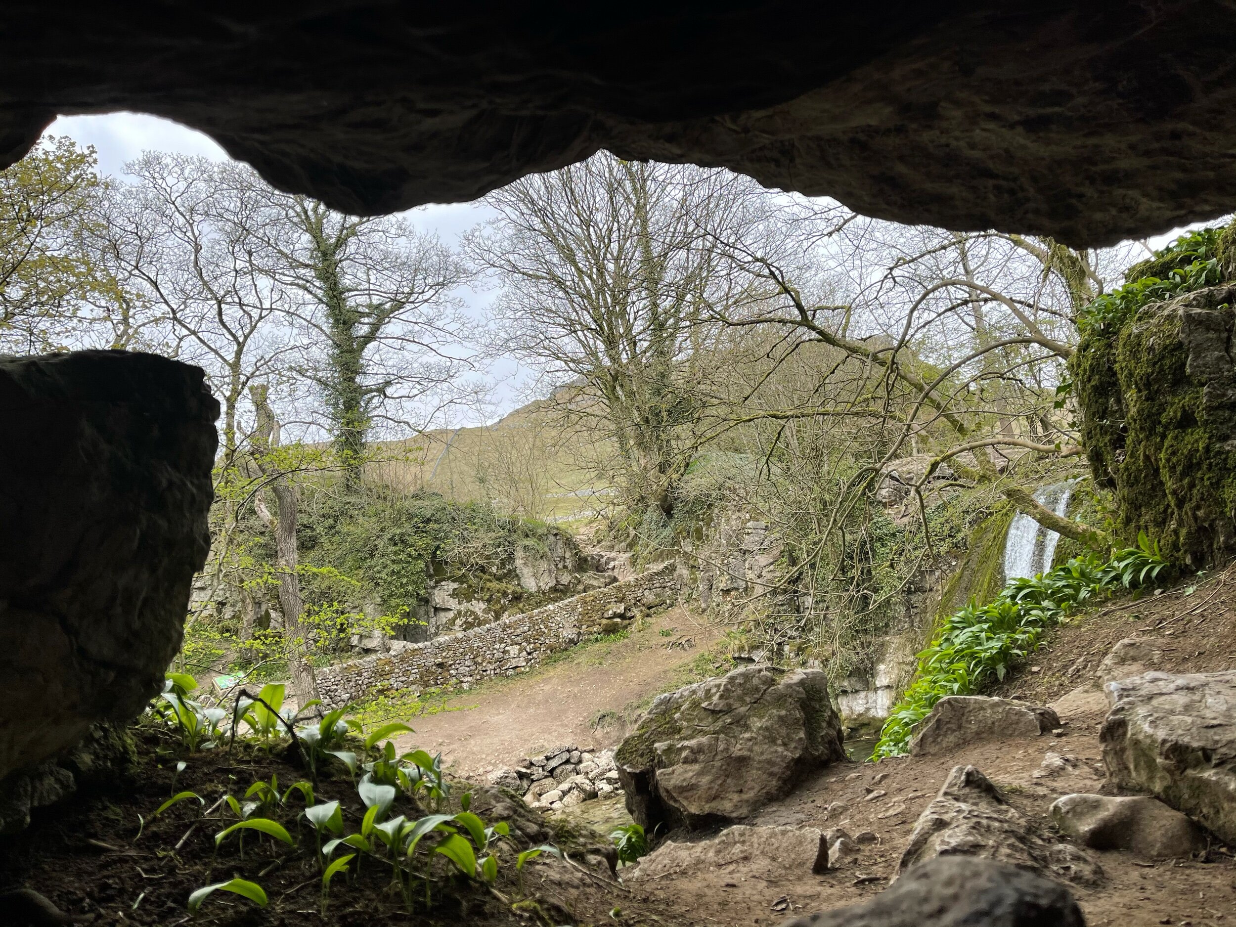
Unlike a lot of other waterfalls in the surrounding area, Gordale Scar allows walkers to discover its beauty without having to undertake a difficult climb en route.
Fancy a dip? Wild swimming has become immensely popular over the past year - and we couldn’t think of a better place to dip a toe in than this one!
All in all, if you’re looking for one of the best walks in the Yorkshire Dale’s — you’re sure to find it in Malham.
Follow the route step by step here — or if you fancy shortening the route, a quick pit stop to the National Park Centre will have you set.
UPHILL CHALLENGES:


WALKS WITH WATERFALLS:


