ALL TRAILS

KERRIDGE HILL LOOP
Discover the beauty of Cheshire from up above in this 6 mile circular walk…

Start: Clough Bank, Bollington, Macclesfield SK10 5NY
Distance: 6.88 miles
Duration: 2-3 hours
Elevation: 1,000 feet
Navigation: follow the route here

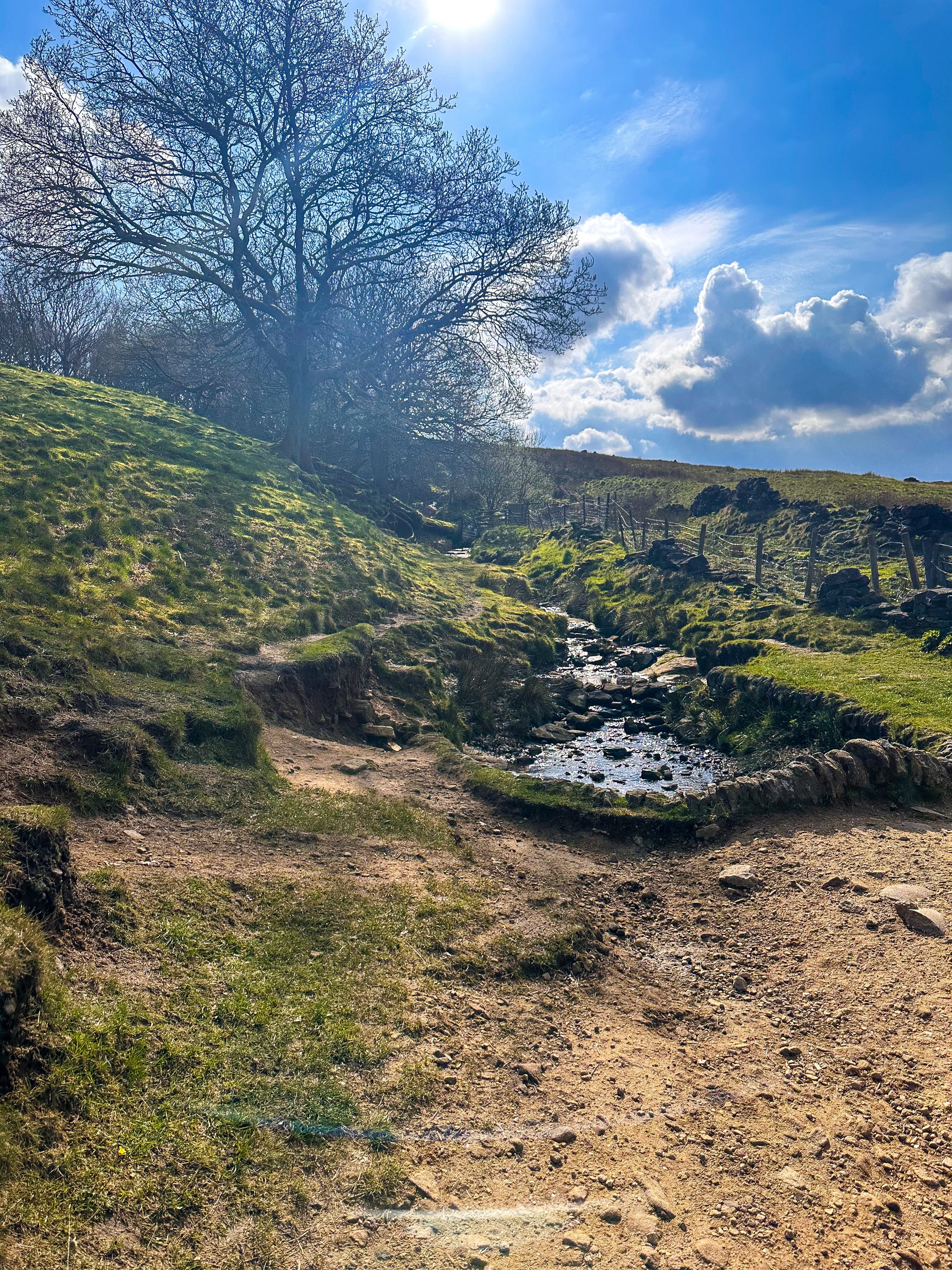
Looking for a bit of history on your next trip outdoors? Look no further than this uphill hike around the Cheshire countryside. Not only does this walk provide excellent views that sweep right across the surrounding area, but you’ll also pass White Nancy fairly early on — a memorial site atop Kerridge Hill, built to commemorate the victory of coalition forces at the Battle of Waterloo.

With its comically shaped physique, White Nancy isn’t your typical historical landmark. Thanks to its lofty position, the site White Nancy sits on had been used as a warning beacon of invasion for centuries, featuring other small structures before Nancy took up residence.
In 1817, the Gaskell family of Ingersley Hall built the structure you see today, in belated commemoration of the victory at Waterloo, 1815. Originally, White Nancy had a door and was used as a summerhouse, but was soon sealed off due to vandalism over the early 20th century.

Whether you’re here for the views or the stories of yesteryear, you’re sure to be taken aback by the undisturbed peacefulness of this route. On a clear day, you can see as far as Snowdonia, Liverpool’s coastal line and the windmills off the Wirral peninsula.

After admiring the views surrounding White Nancy, walking across Kerridge Hill is a must. The route’s quite steep in parts — but the views? So worth it.
So if you’re after a walk that offers incredible views every way you turn, make sure you stop by and see our Nancy soon. With multiple footpaths, woods and fields to explore nearby, you can easily extend this route into a full date out.

Fancy stopping by to visit Nancy soon? Follow the route here

ERRWOOD HALL LOOP, GOYT VALLEY
Panoramic views, magical woodlands and peaceful picnic spots are just some of the reasons you’ll want to head to Goyt Valley — and at just 3 miles for a round trip, you won’t find a better local short walk than this one…

Start: Errwood Hall Car Park, SK11 0AR
Distance: 3 miles
Elevation: 500 feet
Duration: 1-2 hours
Navigation: follow the route here

This relaxed Peak District walk is beautiful in any season, but the way the woods are painted with gorgeous auburn hues come late September should make this route appear high on your list of autumn woodland walks.
Lying just a few miles northwest of Buxton, Goyt Valley is magical place — one that’s gained popularity from visitors since Victorian times.
Once a prosperous and industrious community, the signs of a time gone by are all but extinct, bar from the ruins of Errwood Hall. Back in 1937, the construction of Fernilee Reservoir completely changed this beauty spot’s landscape, but the area remains a wonderfully peaceful place to visit to this day.
Walk Overview
This leisurely three-mile walk takes in three of the most historic sites in this part of the Goyt Valley; the ruins of Errwood Hall, the hilltop cemetery of the Grimshawe family who lived here from around 1840 to 1930, and St Joseph’s Shrine, the small circular stone building dedicated to the Spanish companion of Mrs Jessie Grimshawe. From here the walk ascends a gentle slope to reach the summit of Foxlow Edge before returning to Errwood Hall carpark.

Errwood Hall: A Glimpse into the Past
Errwood Hall, now a ruined site, was once the centerpiece of the Grimshawe estate. Constructed in the 1830s by Samuel Grimshawe, this grand mansion boasted Victorian Gothic architecture and stunning views of the Goyt Valley. The Grimshawe family, who resided here from 1840 to 1930, played a significant role in the area's history.
During its heyday, Errwood Hall hosted lavish gatherings and social events, but tragedy struck in 1930 when the estate was demolished due to financial difficulties. Today, the haunting remains of Errwood Hall stand as a testament to a bygone era, inviting visitors to explore its enchanting grounds.

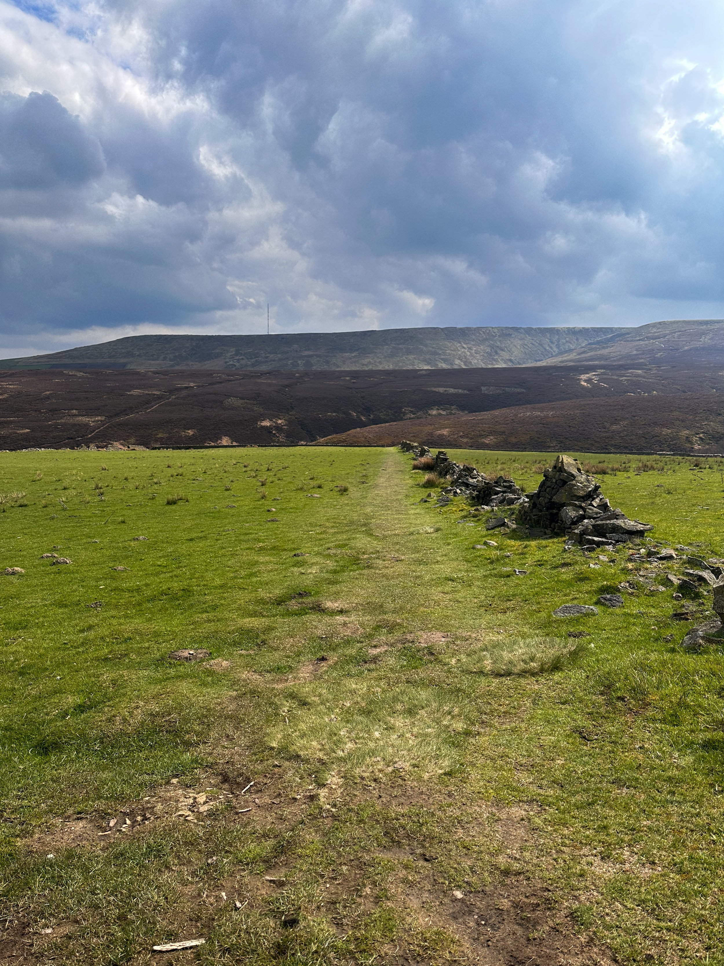
Goyt Valley Highlights
Pym Chair
Folklore more your thing? Local legend has it that a highwayman called Pym used to lay in wait to ambush those who used the old packhorse route, hence the name Pym Chair given to one of the peaks in this mesmerising landscape.
Shining Tor Trig Point
Shining Tor, the highest point in Cheshire, is often included in walks through Goyt Valley… because if you can bag a few trigs in one walk, why wouldn’t you?

Fancy giving this one a go? Follow the route here

THE TRINNACLE: DOVE STONE LOOP
Fancy spending the weekend climbing Saddleworth’s most-snapped landmark? Then a scramble up The Trinnacle is a must…

Start: Binn Green Car Park, Oldham, OL3 7NN
Distance: 4.13 miles
Elevation: 950 feet
Duration: less than 2 hours
Navigation: follow along here

Fed up of the same old flat walking routes around the same old area?
Well, it turns out you don’t have to travel too far out of town to be transported to another world entirely…
Our route round Yeomen Hey Reservoir and up to The Trinnacle will have you feeling like you’re in a Canadian National Park, much less the outskirts of Ashton.

Located high on the hills of Saddleworth Moor, there stands a peculiar rock formation which has well and truly gripped the attention of ramblers far and wide.
Best known as ‘The Trinnacle’, this fork-shaped pillar juts out from the moorlands above Dovestone Reservoir and has attracted the attention of many keen photo opportunists as of late.

Made up of dazzling reservoirs, epic waterfalls, jaw-dropping scenery and steep inclines - alongside a couple of exhilirating scrambles along the river edge - this route really has it all.

Good-to-knows
Parking: Binn Green Car Park (RSPB). Please note, the spaces are limited and fill up quickly. We advise visiting off-peak where possible.
Public Transport: Catch the train to Greenfield Station. This extends the walk by about 50 mins each way.
Amenities: You’ll find an ice cream van and coffee truck at the base of Dove Stone Reservoir, with public toilets in the car park adjacent.
The Trinnacle: While this landmark certainly makes for a great photo opp, please only attempt scrambling if you are confident to do so. Make sure to take great care and only climb if the weather allows for it. The drop at the rear side is certainly no joke.
Fun fact: as we were climbing this one, a passerby shouted “I can’t watch! Make her get down!”, so make sure you have a head for heights whether you’re spectating or tackling it yourself.
Kit: Boots are ESSENTIAL for this one. The route is comprised of steep, slippery, boggy and rocky terrain. White trainer victims: be warned. (We certainly saw a few en-route!).
Take layers. It was a glorious day when we visited but remember where you are… layers are always a good idea.
Refreshments: Due to the idyllic Greenfield location, you’ll have your pick of pubs on this one. We recommend stopping off at The Roaches Lock, just a short drive away from the starting point.
Extending the route: Follow our extended 6 mile version here.
Fancy giving this one ago? Follow along here

SNAKE WOODLANDS LOOP
As magical Peak District walks go, Snake Woodlands is at the top of the list…

Start: Hope Woodland Car Park, S33 0AB
Distance: 3.59 miles
Duration: 1-2 hours
Elevation: 400 feet
Navigation: follow the route here

Easily missable as you drive along Snake’s Pass (A57), this magical wonderland is hidden from view until you venture down into the woodland adjacent.
This stunning pine forest landscape will have you feeling like you’re in the depths of a Canadian national park, much less on the outskirts of Glossop…

Surrounded by rolling hills, pine trees and babbling streams, you won’t be short on fairytale-like scenery on this short circular walk. In fact, this route has a mix of everything: magical woodlands, eerie moorland and even some spooky ruins to boot.

This route in itself is an absolute gem — but if you’re looking to get a few extra miles in, popular Peak District landmarks Higher Shelf Stones and the B52 Crash Site can easily be incorporated. You can follow our Crash Site walk here,

Due limited parking spaces, we advise going off-peak when you can. The good news is, you’ll usually have the place to yourself due to its hard-to-reach location.
Ready to be transported to your very own fairytale? Follow the route here

SK WOODLAND TOUR
A trail so idyllic it’s hard to believe you’re a literal stone’s throw away from the M60…

Start: Woodbank Park, SK1 4JR
Distance: 4 miles
Duration: 1.5 hours
Elevation: 225 feet
Navigation: follow the route here

Having lived in Greater Manchester most of our lives, it always amazes us when we stumble across new-found territory just a stone’s throw away from our old stomping grounds. This route that links up to Midshires Way and Alan Newton Way is one of them!
Named after Stockport’s Olympic medal-winning cyclist, The Alan Newton Way provides a safe off-road route from Marple to Stockport via the Goyt Valley and towards the town centre.

Expect quiet, old farm lanes, a forgotten hall and a wonderful little detour back through the Woodbank’s woodland. We stopped off at Chadkirk for a quick refuel and a wander around Marple Garden Centre. Starting the route from this end means you’ll be able to have a pitstop at Pear Mill’s Vintage Emporium - a must-visit for anyone yet to have a nosey.

To extend the route, you can follow the Way to Etherow Country Park, or join up with the Middlewood Way at Chadkirk.
For us, the highlight came in discovering Goyt Hall Farm, one of Stockport’s many small halls… but due to its remote location, one of the prettiest. This Grade II listed half timbered mansion-house was built around the same time as the popular Bramall Hall. Today, it’s a working farm and stables surrounded by gorgeous bluebell-dotted woods and fields.

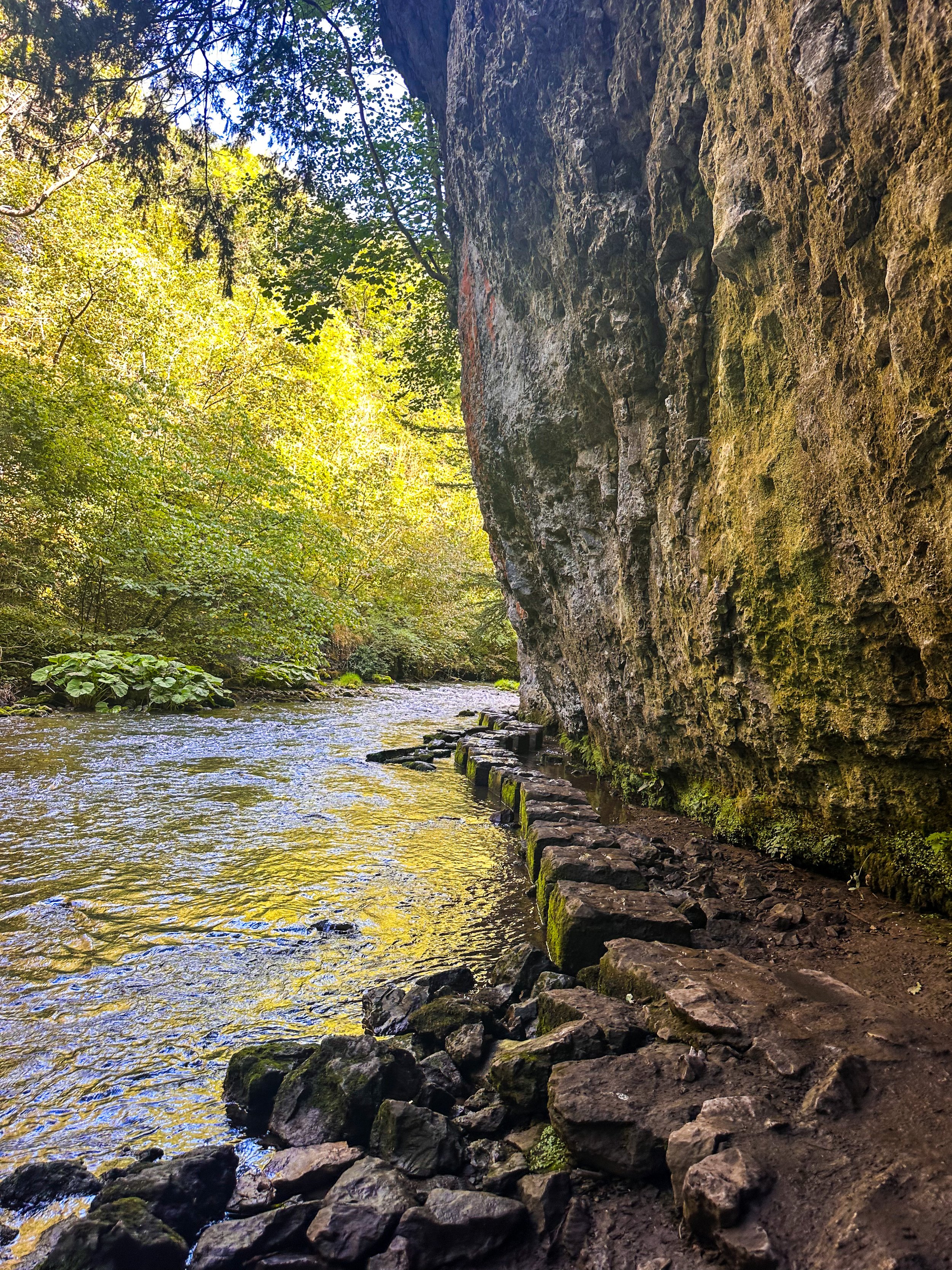
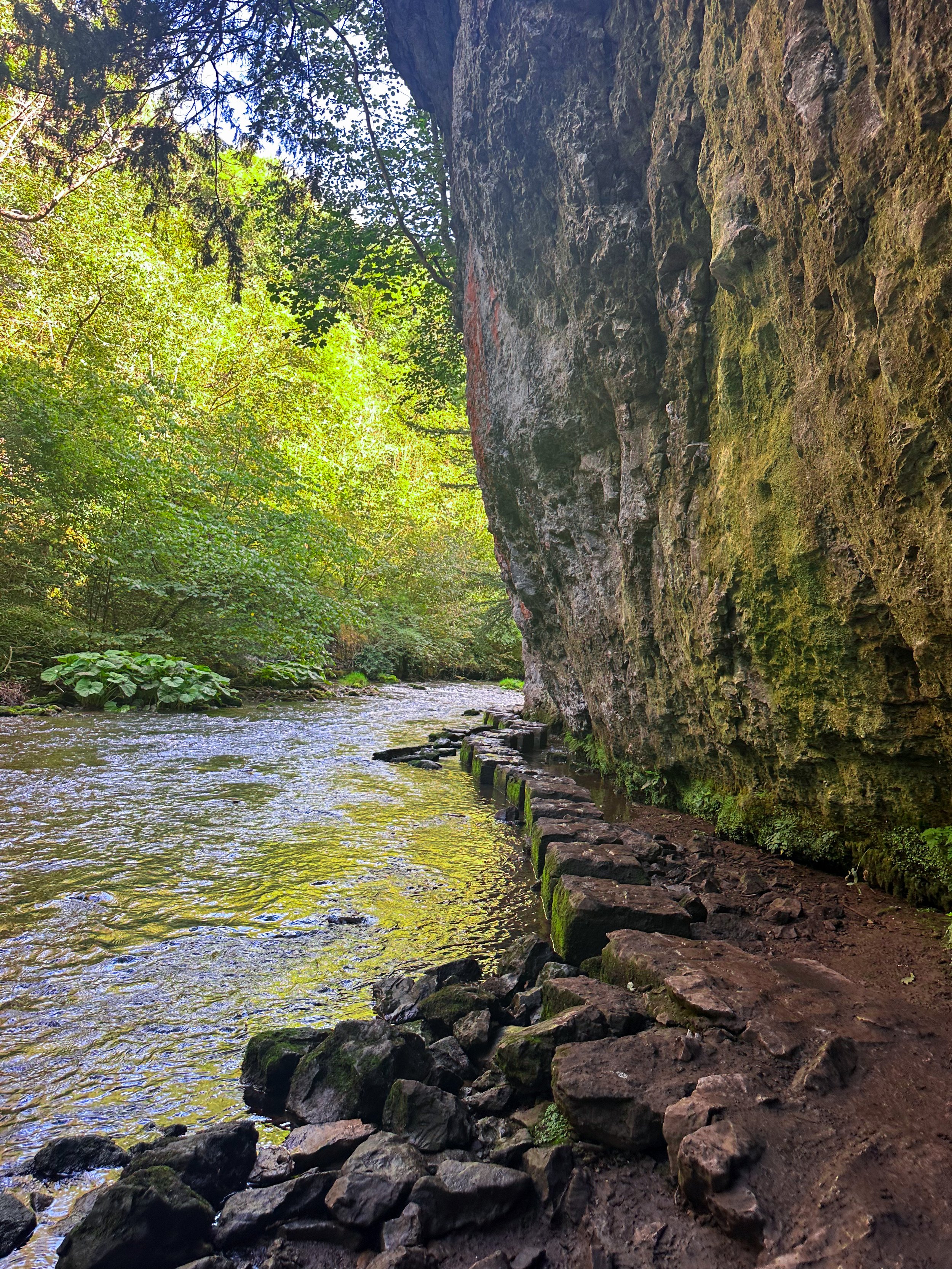
CHEE DALE STEPPING STONES WALK
An easy circular walk in the Peak District, taking you to a beautiful gorge and stepping stones…
Start: Miller’s Dale Car Park, SK17 8SN
Distance: 5 miles
Duration: Approx. 2 hours
Elevation: 525 feet
Navigation: follow our route here

Tucked away beneath the Monsal Trail is the peaceful nature reserve of Chee Dale, where the River Wye meanders through a deep limestone gorge, providing two sets of stepping stones across the river. This route features as one of our Top 10 Walks in the Peak District, and with good reason!
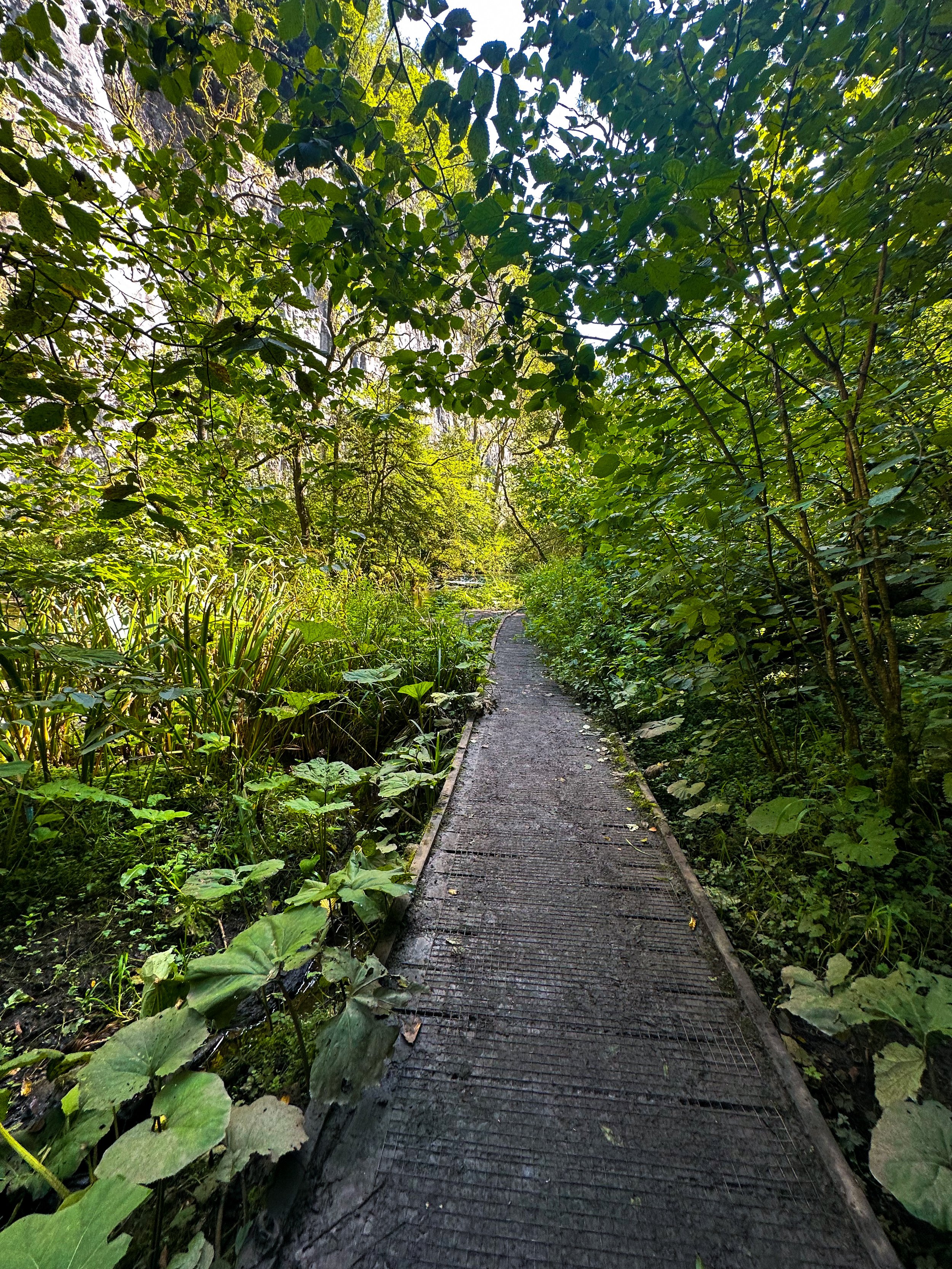
Our Chee Dale Stepping Stones walk starts from Millers Dale Car Park and leads you down into a verdant gorge where you’ll cross two sets of atmospheric stepping stones along the limestone walls, before climbing back up to the Monsal Trail.
This is a slippy route on even the best of weather days, so walking boots definitely required for this one.

While the Dovedale usually takes the Peak District steppingstone limelight, lesser-known Chee Dale makes for a great off-road adventure if you want to beat the crowds.
The stepping stones and surrounding nature reserve – which lie beneath an overhanging cliff of limestone along the River Wye – are truly a must-visit Peak District attraction. So much so, this was our fourth (and certainly not last) visit…
About Chee Dale | Route Good-to-Knows
Made up of a 200ft deep limestone gorge, Chee Dale is filled with woodland, an abundance of wildlife, with the River Wye meandering through.
This walk is a 5mile circular route, first taking you through Chee Dale and along the famous stepping stones, before heading back up to the Monsal Trail and finally making your ascent through the nearby fields, with marvellous views down into the valley.
Miller’s Dale Carpark costs: £5 for the day
If the carpark is full, you can find alternative parking at a large layby just off the A6, on the west side of Chee Dale which offers free parking (Search ‘Chee Dale Layby’ on Google maps).
Public Transport: Make your way to Buxton (either via train or bus), then hop on the number 65 bus, which goes through Miller’s Dale between Tideswell, Linton and Buxton.
Facilities: You’ll find toilets and cafe at Miller’s Dale. Towards the end of the walk at Beech Croft Farm, you will also find Daisies coffee shop.

Fancy giving this one a go? Follow our route here
GOYT DAM
Panoramic views, magical woodlands and peaceful picnic spots are just some of the reasons you’ll want to head to Goyt Valley
Start: Whaley Bridge, SK23 7LX
Distance: 7.71 miles
Elevation: 1,075 feet
Duration: 2-3 hours
Navigation: follow the route here
This relaxed Peak District walk is beautiful in any season, but the way the woods are painted with gorgeous auburn hues come late September should make this route appear high on your list of autumn woodland walks.
Lying just a few miles northwest of Buxton, The Goyt Valley is magical place — one that’s gained popularity from visitors since Victorian times.
Once a prosperous and industrious community, the signs of a time gone by are all but extinct, bar from the ruins of Errwood Hall. Back in 1937, the construction of Fernilee Reservoir completely changed this beauty spot’s landscape, but the area remains a wonderfully peaceful place to visit to this day.

Expect stunning views every way you turn, thanks to a unique landscape which was carved out by successive Ice Ages and the River Goyt. It’s the perfect location for a day of recharging your batteries, with the natural scenery and rolling hills surrounding making for a wonderfully soothing trip outdoors.
With free parking at many of the valley’s landmarks, enjoying a day’s stroll around Goyt Valley is easy — especially if you follow one of the waymarked routes starting from Errwood Car Park.
For us, though, the beauty of this trail starts not in the valley, but in nearby Whaley Bridge. Along the way, expect dense pinewoods and azalea bushes, ruins of worker cottages and even a shrine close to the ruins of an abandoned hall.

And if folklore is more your thing, local legend has it that a highwayman called Pym used to lay in wait to ambush those who used the old packhorse route, hence the name Pym Chair given to one of the peaks in this mesmerising landscape.
Fancy giving this one a go? Follow the route here

QUARRY BANK LOOP, STYAL
An exceptionally easy Sunday stroll starting at an exceptionally good pub…

Start: The Ship Inn, Styal
Distance: 5 miles
Elevation: 275 feet
Duration: approx. 2 hours
Navigation: follow the route here

From enchanting woodlands to proper pub grub, Styal beckons you to explore its surrounds… and with most of the routes on offer under cover of a leafy greenscape, Quarry Bank makes for a great day out, rain or shine.

The Southern Woods provide a great opportunity to explore the wider estate at Quarry Bank and to watch the river twist and turn and make its way to the mill. There are also some hidden gems... take a look at the mill pond and weir.

As well as some fantastic routes along the river Bollin on sections of the Bollin Valley Way, Quarry Bank Mill is well worth a day out of its own. Whether you prefer to take an extended pit stop here or make it your main event, there’s plenty of routes on offer. Ours takes you through Styal Woods, up to The Giant’s Castle Bridge, Norcliffe Chapel and on into Chapel Wood, before dropping down to the River Bollin at the rear of the Quarry Bank Mill Gardens.

From here, we head west following the river coming out next to Manchester Airport runway at the edge of Wilmslow and head across the fields to Pownall Park, back through Quarry Bank Mill and on to The Ship Inn — ready for some much needed pub grub and a well-deserved pint.

Looking for a longer route? This 6.5 mile walk is another great alternative for exploring Styal’s serene surroundings. Check out the route details above, and take your pick.

Fancy following along? Check out the step-by-step route here

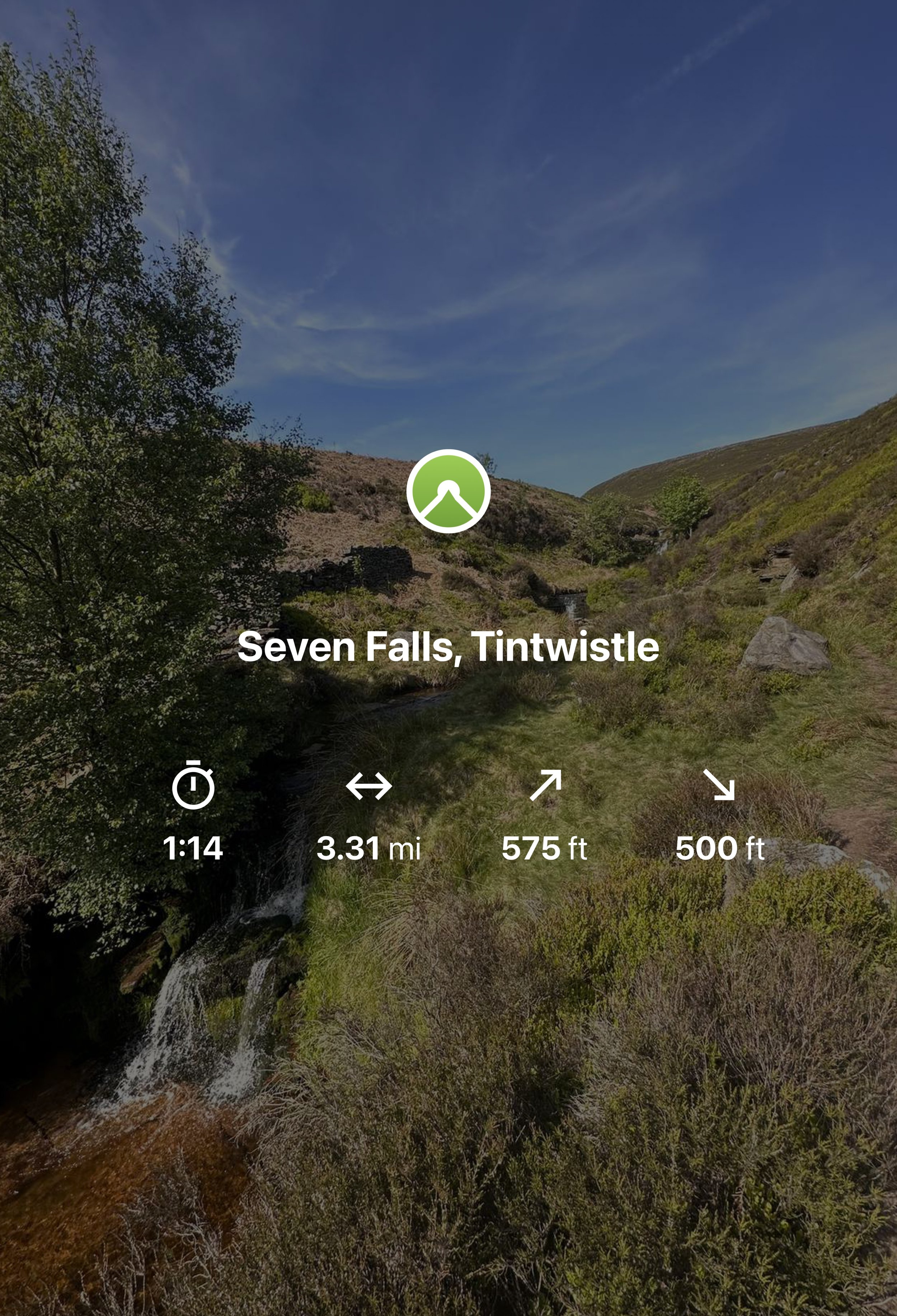
SEVEN FALLS SHORT WALK, TINTWISTLE
A short walk up to one of Greater Manchester’s (not so) hidden wild swimming spots

Start: Arnfield Fly Fishery, SK13 1HP
Distance: 3.31 miles
Elevation: 575 feet
Duration: Approx. 1.5 hours
Navigation: Follow the route here or download GPX file
Public Transport: Start the walk at Hadfield Station, with a mile walk to the start

The Peak District has a number of famous waterfalls within its boundaries that have become famous to walkers and and visitors to the area. Pretty Padley Gorge has a gentle cascading run of waterfalls along the course of Burbage Brook, Kinder Downfall, with a 30-metre drop is the tallest waterfall in the Peak District, and Three Shires Head, the meeting point of Cheshire, Derbyshire and Staffordshire is busy all year round.
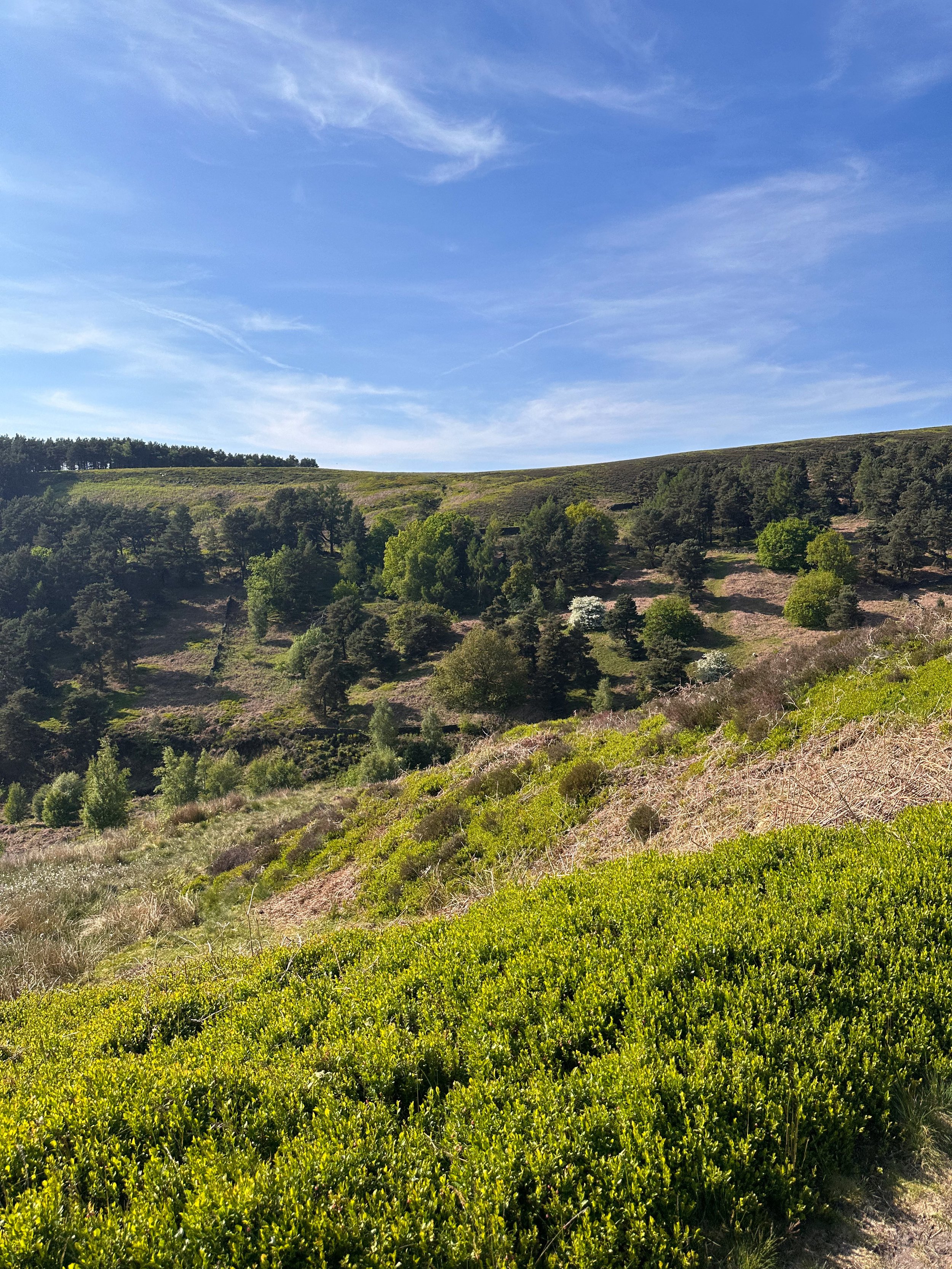
But what about the less well known waterfalls in the National Park? One such place can be found in Tintwistle, an area north of Glossop on the western edge of the Peak District.
The area is well populated with several reservoirs which are great for walking but just to north of them runs Arnfield Brook which is the source of a series of cascading waterfalls and tranquil pool.
Let's dive in…
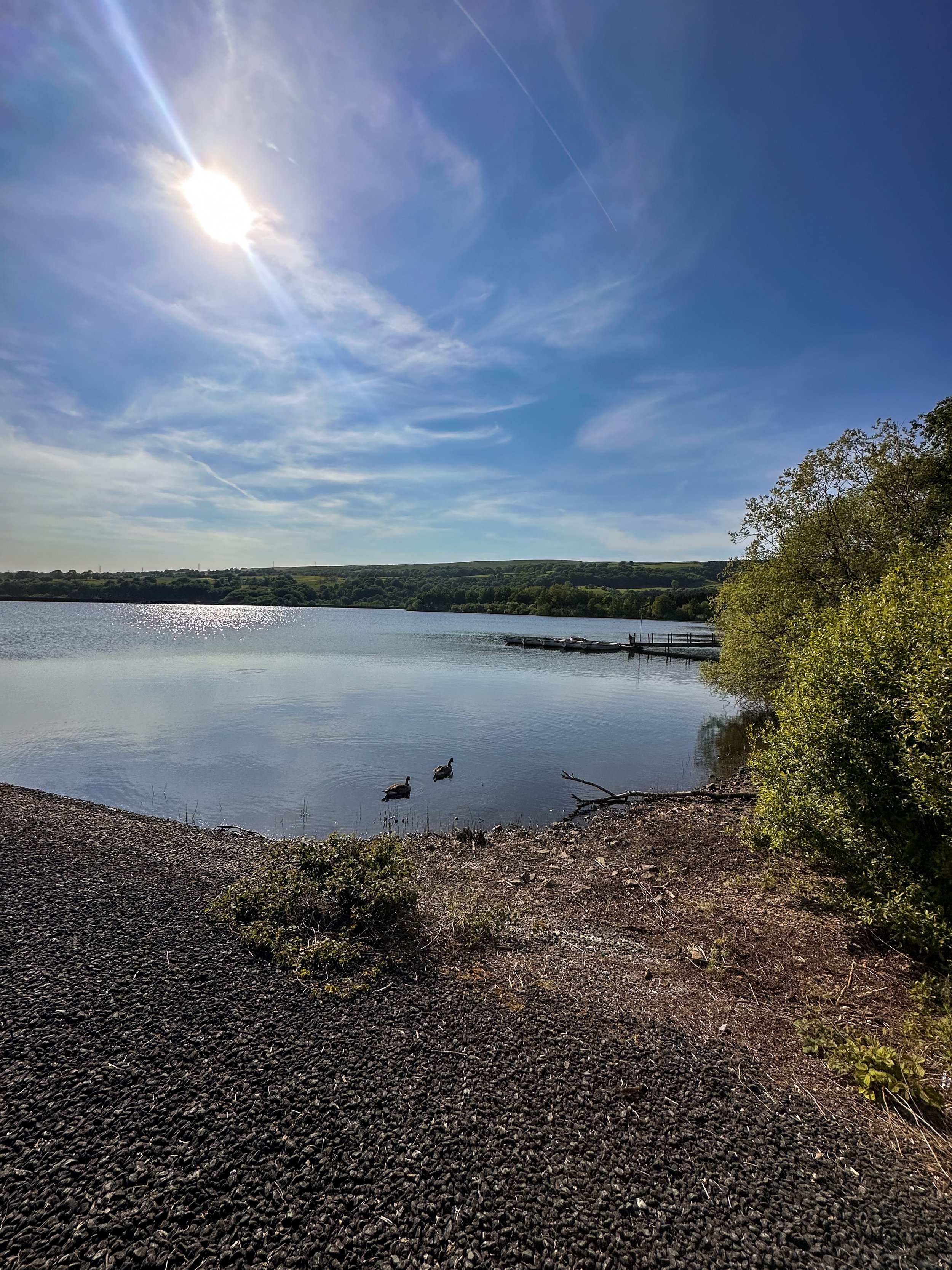
Arnfield Reservoir:

Our adventure starts at Arnfield Reservoir, a serene body of water offering a peaceful escape on the outskirts of Tintwistle and Glossop. Please note, parking here is limited, so arrive early to secure a spot. Take a moment to soak in the picturesque surroundings, grab yourself a cuppa or scan the restaurant and cafe’s menu for your post-walk treat on your return.
Arnfield Fly Fishery Cafe & Restaurant:

At the start of your hike, you'll encounter Arnfield Fly Cafe & Restaurant, a charming eatery nestled amidst the High Peak countryside. It's the perfect spot to refuel and recharge, with a selection of refreshments and delicious food to satisfy your cravings. Take a break, enjoy a cup of tea or coffee, and indulge in some delicious Thai food before continuing your journey towards the falls.
Seven Falls Waterfalls

Prepare to have your breath taken away as we arrive at the stunning Seven Falls waterfalls. While their location may no longer be a secret, it’s the perfect spot to cool off on a sunny Mancunian day. So if a wild dip is your ideal weekend pasttime, make sure to pack a cozzy because this is the ultimate wild swimming spot near Manchester.
Extend your adventure
Once you've soaked up the magic of the Seven Falls, consider extending your adventure by exploring some of the other scenic walks in the area.
Bottoms Reservoir: A leisurely stroll around Bottoms Reservoir offers peaceful surroundings and panoramic views. It's a perfect option for those seeking a shorter, more relaxed walk.
Higher Swineshaw Reservoir: For a slightly longer trek, venture to Higher Swineshaw Reservoir. This circular route treats you to breathtaking vistas and serene landscapes, making it an ideal choice for those craving more nature immersion.
Bottoms Reservoir to Dovestone Reservoir:
Start at Bottoms Reservoir and follow the trail that leads to Dovestone Reservoir. Take in the beauty of both reservoirs and the picturesque landscapes in between. The round trip is approximately 3.5 miles.
Greenfield Circular Walk:
Begin at Bottoms Reservoir and head east towards Greenfield. Explore the charming village and then return to the reservoir using a different path. This circular walk is about 4 miles in length.
Fancy giving this route ago? Follow along here

GIDDY EDGE WALK
Walk on the wild side along Matlock’s ‘Giddy Egde’

Take on a whirlwind adventure through the heart-stopping heights of Giddy Edge on High Tor in Matlock, while also indulging in the romance of Lover's Walk in Matlock Bath. Prepare to have your adrenaline pumping and your heartstrings tugged as we explore these two enchanting highlights in one route.

Start: Matlock Town Centre, DE4
Distance: 5.41 miles
Duration: 2.5 hours
Elevation: 1,175 feet
Navigation: follow the route here

Giddy Edge, High Tor

Giddy Edge… the name alone sends shivers down your spine! This exhilarating path is not for the faint of heart, but for the adventurous souls seeking an adrenaline rush — this one’s for you. As you walk along the narrow cliff edge, take in the awe-inspiring panoramic views of the Derbyshire Dales and don't forget to capture those Instagram-worthy moments!
Along the way, keep an eye out for the famed rock formations, including the legendary "Cromford Tooth." Rumor has it that touching it brings good luck, but be cautious, for superstitions and precipices don't always mix well!
Lover's Walk, Matlock Bath

Now that you've conquered Giddy Edge, it's time to shift gears and embrace the romantic ambiance of Lover's Walk in Matlock Bath. This picturesque riverside path, flanked by lush greenery, is perfect for lovebirds or anyone seeking a moment of tranquility. The charming Victorian-style lampposts transport you back in time… but if you’re after a post hike snack, the nearby Greggs should bring you back to 2023 in no time.
Attractions not to miss during your visit:
Heights of Abraham
After your adrenaline-fuelled adventure along Giddy Edge, make your way to the Heights of Abraham. This unique hilltop park offers cable car rides that will sweep you up into the clouds, providing breathtaking views of the surrounding countryside. It's a perfect opportunity to catch your breath and marvel at the beauty of Matlock below.
Matlock Bath Aquarium
For those fascinated by marine life, a visit to the Matlock Bath Aquarium is a must. Immerse yourself in the captivating world beneath the waves and explore an array of exotic species. From vibrant tropical fish to mesmerizing jellyfish, this aquatic adventure will leave you in awe.
The Fishpond Pub
Walking can make even the hardiest adventurer thirsty, so be sure to stop by The Fishpond Pub. Nestled in the heart of Matlock Bath, this charming establishment serves up a delightful selection of local ales, craft beers, and refreshing beverages. Unwind in their cosy beer garden or warm up by the crackling fireplace on colder days. Cheers to a well-deserved break!

Ready to brave Giddy Egde? Follow the route here

DIGLEY RESERVOIR
Wander alongside woods, through fields and up on the the moor on our Digley walk

Start: Digley Quarry Car Park, (nearest postcode HD9 2QD).
Distance: 5.38 miles
Elevation: 700 feet
Duration: 2 hours
Navigation: follow step-by-step
Located just outside the lovely town of Holmfirth, a walk up to Blackpool Bridge around the outskirts of Digley Reservoir makes a very enjoyable escape into some of Yorkshire’s most glorious countryside. Legend has it that the name Blackpool Bridge comes from the black pools below the bridge that once upon a time local people used to swim in.

This easy going five-mile circular walk will reward you with stunning views across the tops and down into the valley surrounding. You’ll walk through some typical Yorkshire scenes across moorland paths and streams, along lanes and drystone walls in the company of nothing but sheep. Have a well-earned rest and maybe a picnic alongside the Blackpool Bridge along the way, taking a moment to breathe in the fresh air and soak up the peaceful setting.

To begin your journey, park at Digley Quarry Car Park close to the reservoir. The car park is free, but be sure to arrive early to secure a spot, especially on weekends and public holidays. As you start your walk, take a moment to take in the breathtaking views of the surrounding moorlands.
From here, you’ll follow the footpath towards Digley Reservoir, following the footpath that skirts the reservoir. On a sunny day, Digley Reservoir creates picturesque scene you won't soon forget.
Continue your walk towards the moorlands, following the well-marked trail that winds its way through the heather and bracken. The moorlands offer breathtaking views of the surrounding countryside, with panoramic vistas stretching for miles in every direction. Take a moment to catch your breath and appreciate the stunning beauty of this unique landscape.

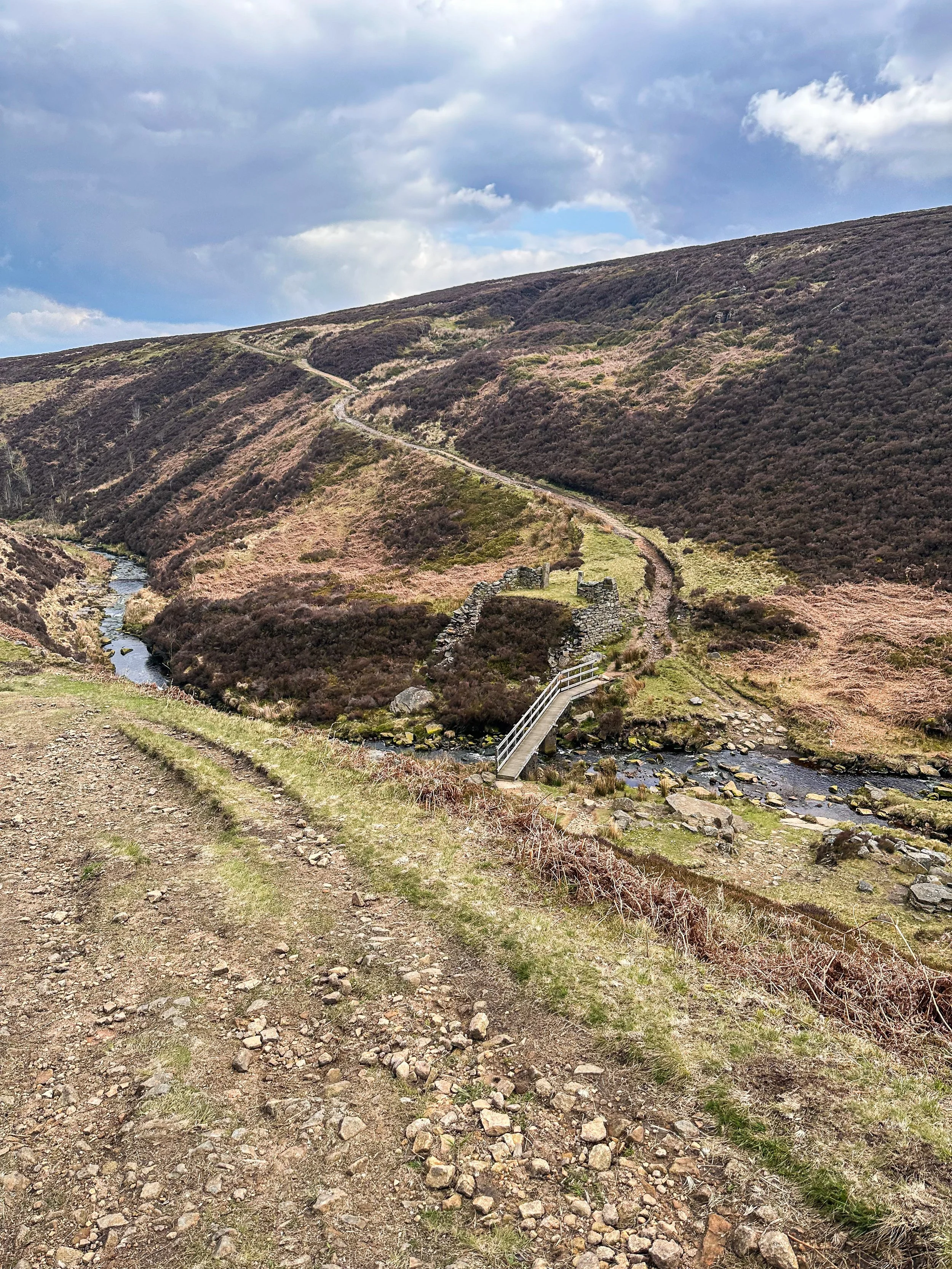
About half way, you’ll find Blackpool Bridge — a great place to pause and take in the beauty of the moorland surrounding. The wooden footbridge sits high above the streams underneath, which flow through Dean Clough and Reap Hill Clough, join here before flowing down through Marsden Clough and into nearby Bilberry Reservoir.
It's quite a steep climb away from the bridge, but fortunately not a very long one. You are soon at the top of the hill and then into the heather-covered open moorland. As you walk along here, the hills in front of you carry the Pennine Way as it climbs towards the desolate peat-bog of Black Hill just to the south.

After dropping down to cross the stream at Hey Clough, there is then a short climb to reach the ruler-straight track known as Issues Road. As you walk along here, there are wonderful long-distance views to the east. The skyline is dominated by Emley Moor television transmitter, but on a clear day you can see the power stations at Ferrybridge and Drax, some forty miles away.
From here, you’ll travel along the outskirts of the reservoir and back up to the quarry at the starting point. Alternativley, if you want to take a short detour into Holme village, there’s a lovely pub called The Fleece which serves great food.
If you manage to resist the temptation of the villlage pub, it’s just a short walk alongside Digley Reservoir before we climb back the starting point.. and that’s it! Your easygoing, 5-mile walk complete.
Fancy giving it a go yourself? Follow our route here

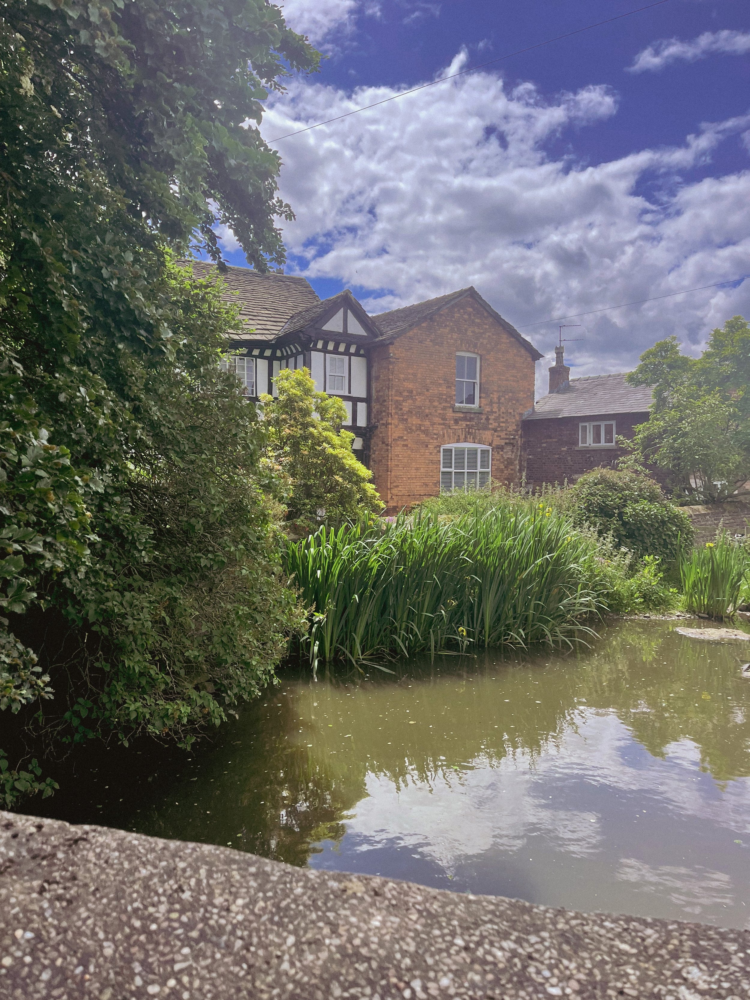
MOTTRAM ST ANDREW LOOP
Cheshire’s best hidden gem: Mottram St Andrew
A circular pub walk perfect for a Sunday stroll not too far from Manchester.

Start: The Bull’s Head, SK10 4QH
Distance: 3 miles
Duration: 1.5 hours
Elevation: 225 feet
Navigation: follow the route here

Looking for a quick escape from the hustle and bustle of city life? A short walk around Mottram St Andrew near Prestbury village may be just the ticket. With untouched countryside, a stunning waterfall, and the convenience of starting and finishing at local boozer, The Bull's Head, this route is perfect for a good old Sunday stroll.

The walk starts at The Bull's Head, a charming pub with a warm and inviting atmosphere. From there, you'll head out into the countryside, taking in quiet lanes, untouched woodlands, horse paddocks and rural footpaths. Despite being so close to the hustle and bustle of nearby Alderley Edge, this short and simple route remains untouched by modern life — giving you a sense of peace and tranquility that is hard to find in the city.

Mottram St Andrew is located about 3 miles north-west of Macclesfield in Cheshire. The walk starts and finishes at The Bull’s Head on Wilmslow Road, just a few hundred yards south of Mottram Hall. The pub has its own car park, although this place is a popular one (we can personally vouch for the delicious food!) so it’s best to avoid peak times.

The walk is relatively short, making it perfect for those who want to enjoy the great outdoors without committing to a full day of hiking. The walking route performs a simple short loop around the local countryside, taking in quiet lanes, horse paddocks and rural footpaths.
And with The Bull's Head as your starting and finishing point, you can look forward to a refreshing pint at the end of your journey.

Mottram St Andrew seems to hide its houses behind high hedges which gives the village a secretive air. We wouldn’t hazard to guess where the centre of the village is — there’s no obvious focal point and one gets the impression that, however quiet and retiring, the villagers like it that way.
But perhaps the best thing about Mottram St Andrew is its charm and character. With its cobbled streets, quaint cottages, and friendly locals, it's the perfect place to unwind and relax. And with plenty of pubs, restaurants, and cafes to choose from in nearby Prestbury Village, you won't be short on options for good food and drink.

Good to knows:
The route includes several gentle climbs and descents throughout. The paths pass through fields and horse paddocks which can be very muddy so good waterproof boots are a must. Each paddock is likely to be holding several horses so take care with dogs. You will need to negotiate 9 stiles, two kissing gates and a flight of steps. Some of the stiles are enclosed with wire fencing so dogs may need a lift over.

Ready for a short mooch & a refreshing pint? Follow the route here
YEOMEN HEY - DOVE STONE LOOP
Discover the best walking routes around Dovestones - a hiker’s guide to the lesser-known trails
Start: Greenfield, OL3 7DD
Distance: 7.33 miles
Elevation: 1,000 feet
Duration: 3-4 hours
Navigation: follow along here
Fed up of the same old walking routes that offer nothing more than a flat path and an average view?
Well, how about getting the best of both?
Our route around Dove Stone Reservoir to Yeomen Hey Reservoir route is not only beautifully flat to begin with but offers a bit of a challenge towards the end, too.
Starting in Greenfield, the route begins with a gentle stroll up to the banks of the reservoir — a great way to warm up before the climb begins.
After about a mile or so around the reservoir, you'll come across a steep climb that leads up to the Yeomen Hey Reservoir. The climb is only short, with most of the ascent accruing in one stint — but the views from the top are more than worth it. From here, you'll be rewarded with insane views, with rolling hills as far as the eye can see.
The path continues along the edge of the Yeomen Hey Reservoir, and it's here that you'll start to hear the sound of rushing water. That's because you're approaching the waterfalls. These waterfalls are a series of cascades that run down the hillside, and they're truly beautiful.
To ascend towards the waterfalls you'll need to do a bit of scrambling. It's not too difficult, but it's worth noting that it can be a bit slippery and caution is required. We recommend climbing up our way and then down the waterfall, but the route can be reversed if you prefer. Just be careful and take your time — and hiking boots are definitely needed for this.
Once you've reached the bottom, take a moment to catch your breath and enjoy the view. You'll see the water cascading down the rocks, creating a natural pool at the bottom. It's a perfect spot for a quick dip if you're feeling brave.
From here, the route continues along the top of the hillside, offering panoramic views of the surrounding countryside. You'll eventually come to the Yeomen Hey Reservoir, where you can take a break and enjoy a picnic by the water's edge.
After your rest, it's time to head back around Dovestones and on to greenfield. The route back is a bit easier, with a gentle descent down the hillside. Take your time and enjoy the view – you'll see the reservoir in a whole new light on the way back.
And better yet, once you’re near the starting point, a pint will be waiting for you at The Clarence in Greenfield.
Enjoy!

ETHEROW TO WERNETH LOOP
Discover Greater Manchester’s best hidden gems on this multiple-country park woodland walk

Start: Etherow Country Park, SK6 5DJ
Distance: 9 miles
Duration: 4 hours
Elevation: 1,500 feet
Navigation: follow the route here

Fancy experiencing all the seasons in one day?
Well, you're in luck, because this walk from Etherow Country Park to Werneth Low Country Park and confused mid-winter weather is what Great Manchester does best.
But don’t worry, with stunning scenery throughout and a dash of history thrown in for good measure, this walk is guaranteed to be a crowd-pleaser.

Our journey begins at Etherow Country Park — one of Britain’s first country parks. With 240 acres of greenspace, this place has an abundance of wildlife… and a waterfall you don’t want to miss!
But don't get too distracted by the fauna, because we've got a hill to climb. Yup, after a short stroll around the Keg Pool its time to climb up to Werneth Low Country Park.
Along the way, take a moment to catch your breath and admire the stunning panoramic view. Once atop The ‘Low, you’ll be quickly rewarded with immense views all across Manchester, the Peak District National Park, and the Cheshire Plain.

History buffs, we've got a couple of landmarks for you to check out. The first is the Werneth Low War Memorial, which was erected in 1921 to honor the soldiers who died in the First World War. It's a stunning monument, made of granite and topped with a bronze figure of a soldier.
After resting your legs and taking in the views, we make our way through the woodlands around Charlesworth and Broadbottom — each nothing short of idyllic. The trees are tall and imposing, the paths are winding and mysterious, and the wildlife is abundant. And if you’re up for a detour, the other landmark to check out is the Broadbottom Viaduct, which spans the valley between Broadbottom and Mottram.

Now, I know what you're thinking: a viaduct doesn't exactly sound like the most thrilling pit stop in the world. But trust me, this one is a real beauty. It was built in 1842, it's made of brick, and it has 27 arches. If you're an aspiring artist or photographer, this is the perfect spot to flex your creative muscles.
So, there we have it: a string of local country parks in one gorgeous route.
As local routes go, this one is a true belter.

Ready to follow along? Follow the route here

PRESTBURY CIRCULAR
If you're looking for a leisurely stroll not too far from home, then a walk round Prestbury village is a must.

Start: Prestbury Village, SK10
Distance: 4.96 miles
Duration: 2 hours
Elevation: 200 feet
Navigation: follow the route here

You can’t beat a local walk, and for us, it doesn’t get much better than one with the holy trinity: quiet surrounds, independent shops and a traditional pub stop to boot. Not only will this short loop around Prestbury Village give you a chance to stretch your legs, but it'll also give you a chance to stretch your Instagram feed with picturesque views of the local area.
The route starts at the village green, where you can take in the views of the picturesque Cheshire countryside. From there, head down Church Street, where you'll be greeted by charming houses and cottages that will make you feel like you've stepped back in time. As you stroll down Church Street, make sure to pop into St. Peter's Church for a dose of medieval architecture and some impressive carvings and stained glass windows.

Next up is the Prestbury War Memorial, a sobering reminder of the sacrifices made by the local community during World War I and II. But don't let the heavy thoughts weigh you down for too long, because the village cricket ground is just around the corner. Take in the sights and sounds of a local game in progress, or just enjoy the quiet surrounds as you meander through the winding bridge-lined woods.

But the real highlight of this walking route is the quaint and charming Bull's Head pub. This traditional pub serves a variety of delicious local ales and ciders, as well as a selection of hearty pub grub. And if the weather's nice, grab a seat in their beer garden for some al fresco dining with a view.
After a pint of the good stuff and a bite to eat, you’re halfway through the route and ready to make your way back to the starting point at the village green.
But don't worry, your journey doesn't have to end here. Prestbury village in Cheshire offers a variety of scenic walking routes, and the charming Bull's Head pub is always open for a well-deserved break. So, pack your comfortable shoes, grab your camera and head to Prestbury Village.
Ready to go? Follow along step-by-step here

BEST WALKS WEST YORKSHIRE: LUMB FALLS
Lumb Falls, located just above the charming Hebden Bridge, is a hidden gem that’s not to be missed.

Start: Bowling Green Car Park, Heptonstall
Distance: 6.7 miles
Duration: 2-3 hours
Elevation: 1,250 feet
Navigation: follow the route here

Nestled in a lush, green valley surrounded by rolling hills that look out onto nearby Heptonstall, this picturesque waterfall is the perfect spot for a peaceful and idyllic walk.
The walk to Lumb Falls is fairly easy, with well-marked trails that lead you through fields and wooded areas. The route takes you along a small stream, with plenty of opportunities to spot wildlife and enjoy the peace and quiet of the countryside. As you approach the falls, the sound of rushing water becomes louder and louder, until you finally reach the viewing platform where you can take in the full majesty of the falls.

After taking in the beauty of the falls, you can continue your walk along the winding path that follows the river. The path takes you through a peaceful wooded area, where you may spot a variety of wildlife.
As you make your way back to the starting point, it's worth stopping off at the nearby village of Heptonstall for a bite to eat and a drink. The village is home to a number of charming pubs and restaurants, including the friendly and welcoming The Cross Inn country pub. Here you can sit outside in the sunshine and enjoy a refreshing drink and a hearty meal, surrounded by stunning views of the surrounding countryside.

Lumb Falls is a must-visit destination for anyone who loves the outdoors. The walk is easy and the views are breathtaking, and the nearby village of Hebden Bridge offers a charming and welcoming place to stop off afterwards. So if you're in the area, be sure to add Lumb Falls to your itinerary – you won't be disappointed!
Whether you're looking for a relaxing escape from the hustle and bustle of daily life or simply want to appreciate the beauty of nature, a walk through Lumb Falls is an experience you won't soon forget.

If you're feeling more adventurous, why not try the Hebden Hey Trail? This challenging route takes you through the heart of the Pennine hills, with stunning views of the surrounding landscape. The trail is around 13 miles in total, so it's best suited to experienced walkers.
No matter what your fitness level or interests, there's a walking route in Hebden Bridge to suit you. So pack your walking boots, grab your camera, and discover the beauty of this charming village on foot.

Fancy giving this one a go? Follow the route here
BEST WOODLAND WALKS NEAR MANCHESTER: ASHOP CLOUGH
If you’re looking for a magical walk as we head towards the most magical time of the year, a trip to Ashop Clough and the Snake Woodlands is a must
Start: Hope Woodland Car Park, S33 0AB
Distance: 3.59 miles
Duration: 1-2 hours
Elevation: 400 feet
Navigation: follow the route here
Easily missable as you drive along Snake’s Pass (A57), this magical wonderland is hidden from view until you venture down into the woodland adjacent.
This stunning pine forest landscape will have you feeling like you’re in the depths of a Canadian national park, much less on the outskirts of Glossop…
Surrounded by rolling hills, pine trees and babbling streams, you won’t be short on fairytale-like scenery on this short circular walk. In fact, this route has a mix of everything: magical woodlands, eerie moorland and even some spooky ruins to boot.
This route in itself is an absolute gem — but if you’re looking to get a few extra miles in, popular Peak District landmarks Higher Shelf Stones and the B52 Crash Site can easily be incorporated. You can follow our Crash Site walk here,
Due limited parking spaces, we advise going off-peak when you can. The good news is, you’ll usually have the place to yourself due to its hard-to-reach location.
Ready to be transported to your very own fairytale? Follow the route here

BEST WALKS NEAR WIGAN: FAIRY GLEN LOOP
Looking to escape to an enchanting woodland over the weekend? This short Greater Manchester walk has your back
Start: Parbold Hill Viewpoint, Wigan, WN8 7TH
Distance: 4.24 miles
Elevation: 400 feet
Duration: 1-2 hours
Navigation: follow the route here
From pie trails to the infamous pier… there’s no doubt a day in Wigan is a day well spent. It’s said the Manchester town has become the centre of the pie-making and pie-eating world, and who are we to argue with that?
So if you’re after a day of fine pastry once you’ve headed off on your Sunday stroll, you’re in for a treat with this one.
Starting from Parbold Hill Viewpoint, this short loop is great for a Sunday stroll with four-legged pals in tow. Before long, you’ll start your descent towards the Liverpool-Leeds canal, before ascending back up to Appley Bridge, which is where the real gem of this walk lies: Fairy Glen.
Nestled on the side of Parbold Hill, Fairy Glen is a serene patch of forest with picturesque cascades, streams and waterfalls, with plenty of hiking trails perfect for extending your walk should you wish to venture further.

Fancy giving this woodland walk in Manchester a go? Follow the route here
GOYT DAM
Panoramic views, magical woodlands and peaceful picnic spots are just some of the reasons you’ll want to head to Goyt Valley
Start: Whaley Bridge, SK23 7LX
Distance: 7.71 miles
Elevation: 1,075 feet
Duration: 2-3 hours
Navigation: follow the route here
This relaxed Peak District walk is beautiful in any season, but the way the woods are painted with gorgeous auburn hues come late September should make this route appear high on your list of autumn woodland walks.
Lying just a few miles northwest of Buxton, The Goyt Valley is magical place — one that’s gained popularity from visitors since Victorian times.
Once a prosperous and industrious community, the signs of a time gone by are all but extinct, bar from the ruins of Errwood Hall. Back in 1937, the construction of Fernilee Reservoir completely changed this beauty spot’s landscape, but the area remains a wonderfully peaceful place to visit to this day.
Expect stunning views every way you turn, thanks to a unique landscape which was carved out by successive Ice Ages and the River Goyt. It’s the perfect location for a day of recharging your batteries, with the natural scenery and rolling hills surrounding making for a wonderfully soothing trip outdoors.
With free parking at many of the valley’s landmarks, enjoying a day’s stroll around Goyt Valley is easy — especially if you follow one of the waymarked routes starting from Errwood Car Park.
For us, though, the beauty of this trail starts not in the valley, but in nearby Whaley Bridge. Along the way, expect dense pinewoods and azalea bushes, ruins of worker cottages and even a shrine close to the ruins of an abandoned hall.
And if folklore is more your thing, local legend has it that a highwayman called Pym used to lay in wait to ambush those who used the old packhorse route, hence the name Pym Chair given to one of the peaks in this mesmerising landscape.
Fancy giving this one a go? Follow the route here

THORPE CLOUD
Gothic manors… idyllic tearooms… and a trig point to boot — this walk in Ashbourne has it all

Start: Blore Pastures Carpark, DE6 2BS
Distance: 5.49 miles
Duration: 2.5 hours
Elevation: 1,000 feet
Navigation: follow the route here

Whether you’re here for the stepping stones across the River Manifold, or fancy indulging in the history of this quaint town’s old manor house, a day trip to Ilam Park is always a good idea.
After a meander around Ilam Hall, our route takes you up Thorpe Cloud as you summit the hill for breathtaking views across the dale, and return home via the stepping stones across the River Dove.

Thorpe Cloud is found in the White Peaks on the southern end of Dovedale — a gorgeous limestone hill that attracts thousands of visitors each year thanks to its unique shape and close proximity to Dovedale Stepping Stones.
The route up to the summit is easy-to-follow, navigated by blue markers on signposts. With some steep parts that’re a good challenge for beginners, the walk is short and sweet with plenty of options to extend if you’re feeling particularly energetic.
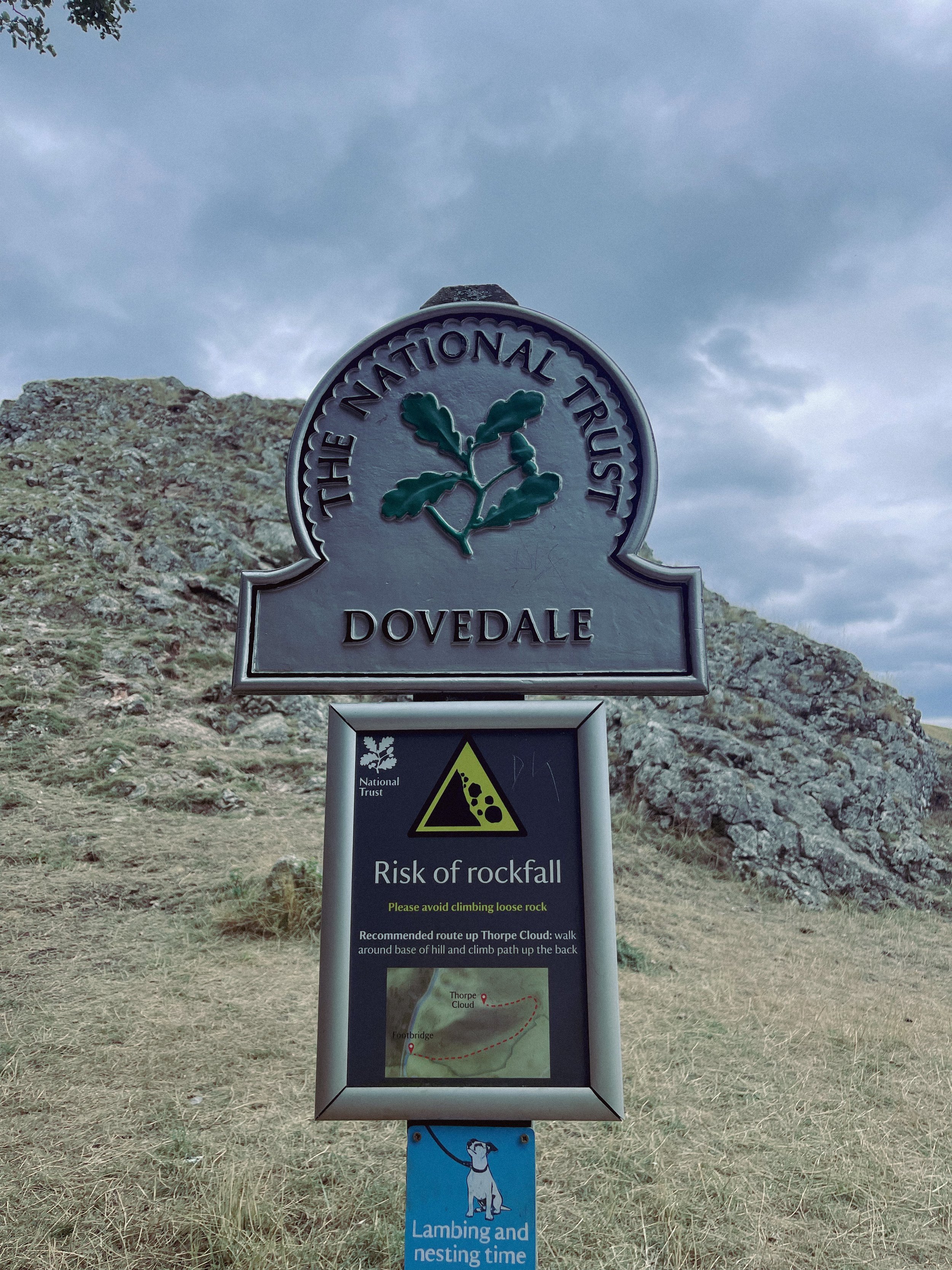
The Stepping Stones are a very popular Peak District attraction, so if you’re wanting to explore free from pedestrian traffic, we’d definitely recommend visiting off-peak if that’s an option for you.
That said, they’re a must-do Peak activity… and well worth the visit!

Grab yer hiking boots and follow one of our favourite Peak District walks here
UPHILL CHALLENGES:


WALKS WITH WATERFALLS:


