ALL TRAILS

BAMFORD AND STANAGE EDGE CIRCULAR
Breathtaking scenery? Check. Two iconic Peak District landmarks in one walk? This route has you covered…

Start: Heatherdene Car Park, S33 0BY
Distance: 7 miles
Duration: 3 hours
Elevation: 1,150 feet
Difficulty: Moderate
Navigation: Download the GPX file here
This scenic Bamford Edge walk also visits Stanage Edge, taking in some of the best views in the Peak District.
Walk Highlights
Bamford Moor
As you ascend from Heatherdene, Bamford Moor presents itself with rugged landscapes and untamed beauty. This expanse of open moorland offers panoramic views, babbling brooks, and a stone circle dating back to The Bronze Age. Keep your camera ready!
Stanage Edge
Situated north of Hathersage, Stanage Edge is a popular place for walkers and for rock climbing with stunning views of the Dark Peak moorlands and the Hope Valley. The gritstone edge stretches for approximately 4 miles and featured in the classic film ‘Pride & Prejudice’ starring Keira Knightley.
Bamford Edge
Bamford Edge is an overhang of gritstone that sticks out over the beautiful Bamford Moor. The ridge is renowned for its distinctive rock formations, including the photogenic 'Great Tor'. It lies elevated on the moor, close to the quintessential Derbyshire village of Bamford in the Peak District National Park.
Bamford Edge is approximately 1381 ft above sea level or 420 metres high. From the top, you get some of the best views of Ladybower Reservoir, Win Hill, Lose Hill, The Great Ridge, Crook Hill, and Hope Valley — all from just a relatively short walk to the top.
It’s extremely popular with rock climbers, walkers, and those wanting to get some fabulous photos on an iconic overhanging ledge.
Tips
Facilities are limited on this one. You’ll find public toilets available at the start of the walk (Heatherdene Car Park) and a cafe at nearby Derwent Reservoir if you’re looking to extend the route.
Check the weather: The weather atop the moor can be unpredictable. Dress in layers and be prepared for changes.
Respect the environment: The Peak District is a protected area. Stick to paths, and don't disturb wildlife.
Arrive early: Heatherdeane Car Park gets incredibly crowded during the weekend, visit off-peak where you can.
Catch a sunset: Looking for a shorter walk? Check out our Bamford Edge sunset variation below, clocking up just 3 miles.
Plan ahead: Ensure you have enough water, snacks, and a map. Mobile signal can be patchy, so physical maps are handy.
Leave the white trainers at home! The area around the moors can get incredibly boggy — so definitely bring your boots for this one.
Best time to visit: Early morning or late afternoon to avoid the crowds and catch the golden light.
Safety first: The edges can be slippery, especially after rain. Wear sturdy boots and watch your step.
Leave no trace: Preserve the beauty of the Peaks. Take your rubbish with you and stick to the paths.
SUNSET WALK VARIATION

Short on time, or simply want to head up for sunset? This short loop up to Bamford Edge is a great alternative. The walk up to the edge only takes approx. 20 minutes with just a short ascent up to the ridge — the perfect route to watch the sun set over Ladybower.
Tip: The walk up can get incredibly boggy after rainfall, so definitely bring your boots for this one.
Bamford Circular Walk

Distance: 3.53 miles
Elevation: 650 feet
Duration: 1.5 hours
Start: Heatherdene Car Park, S33 0BY
Navigation: follow the route here
Despite clocking up just a few miles overall, this Bamford loop offers some of the best views in the Peak District. With just a short climb at the start, you walk towards Bamford Edge and are instantly rewarded with incredible views of Ladybower and Derwent Reservoirs.
Just opposite, you’ll also find another great vantage point in the form of Win Hill. The easygoing nature of this route makes it a popular location for sunrise and sunset.
Up top, you’ll be spoilt choice if you’re looking to extend the walk—with the option to include both Ladybower and Derwent Reservoirs if you prefer to skip the climb and soak up the views at the bottom.
Looking for more walks like this one? Check out our latest adventures on Instagram

CHEE DALE STEPPING STONES WALK
An easy circular walk in the Peak District, taking you to a beautiful gorge and stepping stones…
Start: Miller’s Dale Car Park, SK17 8SN
Distance: 5 miles
Duration: Approx. 2 hours
Elevation: 525 feet
Navigation: follow our route here

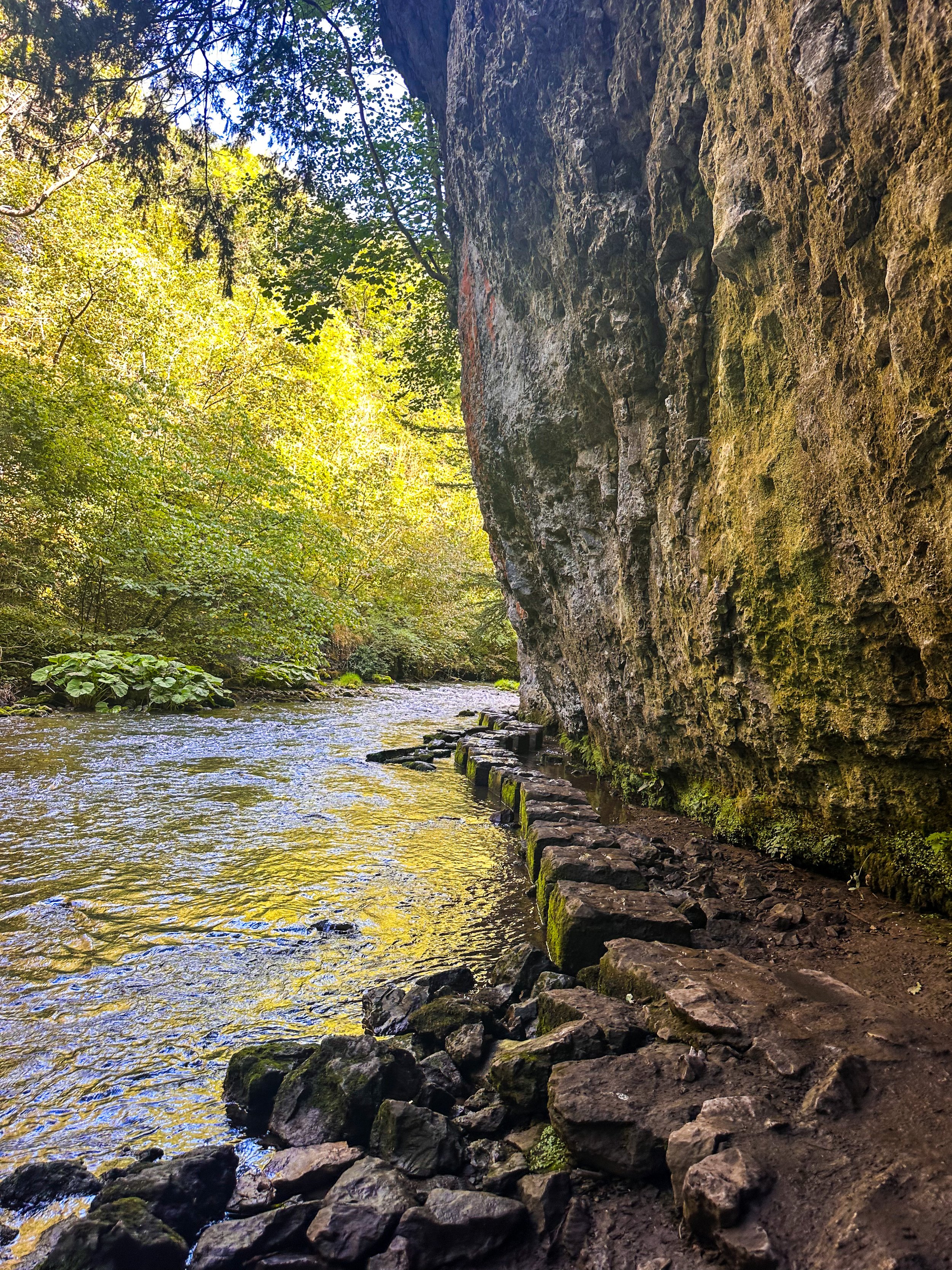
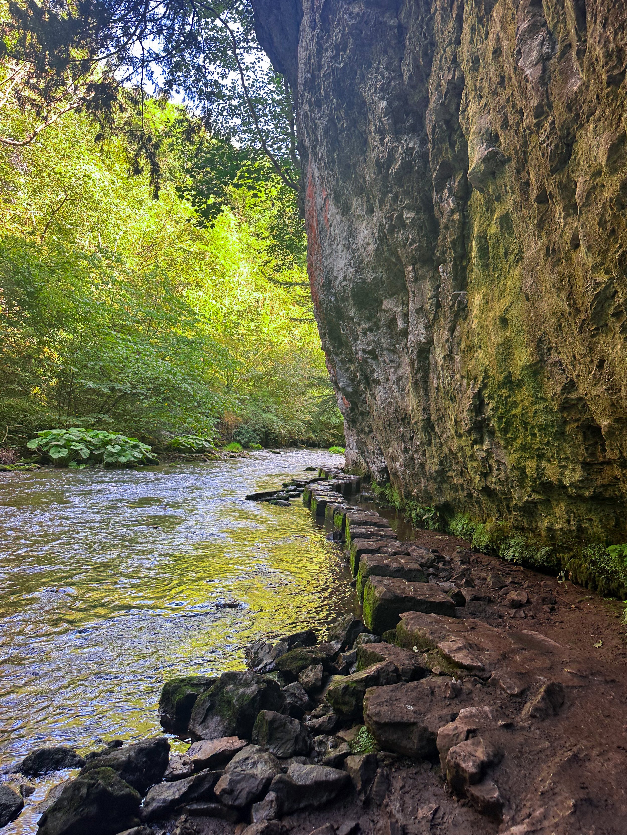
Tucked away beneath the Monsal Trail is the peaceful nature reserve of Chee Dale, where the River Wye meanders through a deep limestone gorge, providing two sets of stepping stones across the river. This route features as one of our Top 10 Walks in the Peak District, and with good reason!
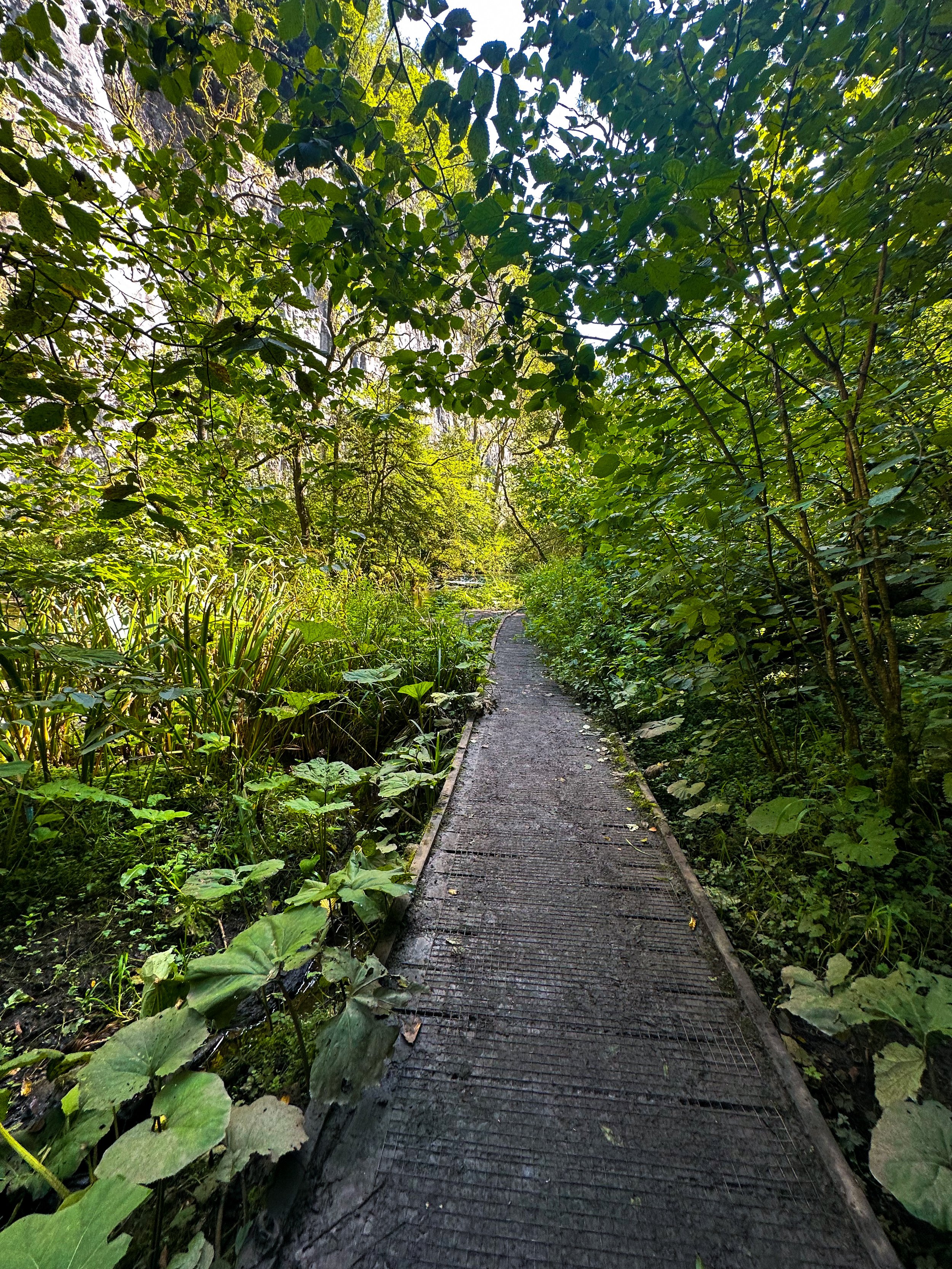
Our Chee Dale Stepping Stones walk starts from Millers Dale Car Park and leads you down into a verdant gorge where you’ll cross two sets of atmospheric stepping stones along the limestone walls, before climbing back up to the Monsal Trail.
This is a slippy route on even the best of weather days, so walking boots definitely required for this one.

While the Dovedale usually takes the Peak District steppingstone limelight, lesser-known Chee Dale makes for a great off-road adventure if you want to beat the crowds.
The stepping stones and surrounding nature reserve – which lie beneath an overhanging cliff of limestone along the River Wye – are truly a must-visit Peak District attraction. So much so, this was our fourth (and certainly not last) visit…
About Chee Dale | Route Good-to-Knows
Made up of a 200ft deep limestone gorge, Chee Dale is filled with woodland, an abundance of wildlife, with the River Wye meandering through.
This walk is a 5mile circular route, first taking you through Chee Dale and along the famous stepping stones, before heading back up to the Monsal Trail and finally making your ascent through the nearby fields, with marvellous views down into the valley.
Miller’s Dale Carpark costs: £5 for the day
If the carpark is full, you can find alternative parking at a large layby just off the A6, on the west side of Chee Dale which offers free parking (Search ‘Chee Dale Layby’ on Google maps).
Public Transport: Make your way to Buxton (either via train or bus), then hop on the number 65 bus, which goes through Miller’s Dale between Tideswell, Linton and Buxton.
Facilities: You’ll find toilets and cafe at Miller’s Dale. Towards the end of the walk at Beech Croft Farm, you will also find Daisies coffee shop.

Fancy giving this one a go? Follow our route here

QUARRY BANK LOOP, STYAL
An exceptionally easy Sunday stroll starting at an exceptionally good pub…

Start: The Ship Inn, Styal
Distance: 5 miles
Elevation: 275 feet
Duration: approx. 2 hours
Navigation: follow the route here

From enchanting woodlands to proper pub grub, Styal beckons you to explore its surrounds… and with most of the routes on offer under cover of a leafy greenscape, Quarry Bank makes for a great day out, rain or shine.

The Southern Woods provide a great opportunity to explore the wider estate at Quarry Bank and to watch the river twist and turn and make its way to the mill. There are also some hidden gems... take a look at the mill pond and weir.

As well as some fantastic routes along the river Bollin on sections of the Bollin Valley Way, Quarry Bank Mill is well worth a day out of its own. Whether you prefer to take an extended pit stop here or make it your main event, there’s plenty of routes on offer. Ours takes you through Styal Woods, up to The Giant’s Castle Bridge, Norcliffe Chapel and on into Chapel Wood, before dropping down to the River Bollin at the rear of the Quarry Bank Mill Gardens.

From here, we head west following the river coming out next to Manchester Airport runway at the edge of Wilmslow and head across the fields to Pownall Park, back through Quarry Bank Mill and on to The Ship Inn — ready for some much needed pub grub and a well-deserved pint.

Looking for a longer route? This 6.5 mile walk is another great alternative for exploring Styal’s serene surroundings. Check out the route details above, and take your pick.

Fancy following along? Check out the step-by-step route here

MOTTRAM ST ANDREW LOOP
Cheshire’s best hidden gem: Mottram St Andrew
A circular pub walk perfect for a Sunday stroll not too far from Manchester.

Start: The Bull’s Head, SK10 4QH
Distance: 3 miles
Duration: 1.5 hours
Elevation: 225 feet
Navigation: follow the route here

Looking for a quick escape from the hustle and bustle of city life? A short walk around Mottram St Andrew near Prestbury village may be just the ticket. With untouched countryside, a stunning waterfall, and the convenience of starting and finishing at local boozer, The Bull's Head, this route is perfect for a good old Sunday stroll.

The walk starts at The Bull's Head, a charming pub with a warm and inviting atmosphere. From there, you'll head out into the countryside, taking in quiet lanes, untouched woodlands, horse paddocks and rural footpaths. Despite being so close to the hustle and bustle of nearby Alderley Edge, this short and simple route remains untouched by modern life — giving you a sense of peace and tranquility that is hard to find in the city.

Mottram St Andrew is located about 3 miles north-west of Macclesfield in Cheshire. The walk starts and finishes at The Bull’s Head on Wilmslow Road, just a few hundred yards south of Mottram Hall. The pub has its own car park, although this place is a popular one (we can personally vouch for the delicious food!) so it’s best to avoid peak times.

The walk is relatively short, making it perfect for those who want to enjoy the great outdoors without committing to a full day of hiking. The walking route performs a simple short loop around the local countryside, taking in quiet lanes, horse paddocks and rural footpaths.
And with The Bull's Head as your starting and finishing point, you can look forward to a refreshing pint at the end of your journey.

Mottram St Andrew seems to hide its houses behind high hedges which gives the village a secretive air. We wouldn’t hazard to guess where the centre of the village is — there’s no obvious focal point and one gets the impression that, however quiet and retiring, the villagers like it that way.
But perhaps the best thing about Mottram St Andrew is its charm and character. With its cobbled streets, quaint cottages, and friendly locals, it's the perfect place to unwind and relax. And with plenty of pubs, restaurants, and cafes to choose from in nearby Prestbury Village, you won't be short on options for good food and drink.

Good to knows:
The route includes several gentle climbs and descents throughout. The paths pass through fields and horse paddocks which can be very muddy so good waterproof boots are a must. Each paddock is likely to be holding several horses so take care with dogs. You will need to negotiate 9 stiles, two kissing gates and a flight of steps. Some of the stiles are enclosed with wire fencing so dogs may need a lift over.

Ready for a short mooch & a refreshing pint? Follow the route here
BAMFORD RIDGE
Derwent Edge hogs the limelight around Ladybower—this short loop offers the immense views… without as much legwork
Distance: 3.53 miles
Elevation: 650 feet
Duration: 1.5 hours
Start: Heatherdene Car Park, S33 0BY
Navigation: follow the route here

This is a real treat of a walk, offering some of the best views in the Peak District. With just a short climb at the start, you walk towards Bamford Edge and are rewarded with incredible views of Ladybower and Derwent Reservoirs.

Just opposite, you’ll also find another great vantage point in the form of Win Hill. The easygoing nature of this route makes it a popular location for sunrise and sunset.
Up top, you’ll be spoilt for walking-trail choice if you’re looking to extend the walk—with the option to include both Ladybower and Derwent Reservoirs if you’re feeling particularly energetic.
Bamford Edge itself is a beautiful photo spot with many amazing rock formations. Facilities are limited on this trail, but there are public toilets available at the start of the walk (Heatherdene Car Park) and a cafe at Derwent Reservoir for those extending the route.

Fancy giving this one a go? Follow the route here
UPHILL CHALLENGES:


WALKS WITH WATERFALLS:


