ALL TRAILS

KERRIDGE HILL LOOP
Discover the beauty of Cheshire from up above in this 6 mile circular walk…

Start: Clough Bank, Bollington, Macclesfield SK10 5NY
Distance: 6.88 miles
Duration: 2-3 hours
Elevation: 1,000 feet
Navigation: follow the route here

Looking for a bit of history on your next trip outdoors? Look no further than this uphill hike around the Cheshire countryside. Not only does this walk provide excellent views that sweep right across the surrounding area, but you’ll also pass White Nancy fairly early on — a memorial site atop Kerridge Hill, built to commemorate the victory of coalition forces at the Battle of Waterloo.

With its comically shaped physique, White Nancy isn’t your typical historical landmark. Thanks to its lofty position, the site White Nancy sits on had been used as a warning beacon of invasion for centuries, featuring other small structures before Nancy took up residence.
In 1817, the Gaskell family of Ingersley Hall built the structure you see today, in belated commemoration of the victory at Waterloo, 1815. Originally, White Nancy had a door and was used as a summerhouse, but was soon sealed off due to vandalism over the early 20th century.

Whether you’re here for the views or the stories of yesteryear, you’re sure to be taken aback by the undisturbed peacefulness of this route. On a clear day, you can see as far as Snowdonia, Liverpool’s coastal line and the windmills off the Wirral peninsula.

After admiring the views surrounding White Nancy, walking across Kerridge Hill is a must. The route’s quite steep in parts — but the views? So worth it.
So if you’re after a walk that offers incredible views every way you turn, make sure you stop by and see our Nancy soon. With multiple footpaths, woods and fields to explore nearby, you can easily extend this route into a full date out.

Fancy stopping by to visit Nancy soon? Follow the route here

NEW MILLS MILLENIUM WALKWAY WALK
Come with us on this short (but oh so scenic) walk just 20 minutes from Manchester…

On initial glance, New Mills may look like any ordinary Peak District village: small, picturesque with little much-to-do around the town. Venture just a few steps downwards towards the River Sett, and you enter another landscape entirely.
We’ve partnered with In Our Nature, Manchester’s biggest climate movement, to show you don’t always need to grab for the car keys to enjoy a wonderful day out in the Peaks.

Whether you want a lazy Sunday stroll or are seeking a fully day of exploring, New Mills is a great base for all types of adventures.
That’s why we’ve got two routes for you to choose from. The first, a short 4 mile loop that leaves plenty of time to explore the many wonderful independent shops and cafes in New Mills town centre. The second is a 10 mile loop which you can start from either New Mills or Marple, with easy train links from Manchester to both starting points.
Route #1: The Torrs Circular
Start: New Mills Central Station
Distance: 4 miles
Elevation: 300 feet
Difficulty: Easy
Duration: 1.5 hours
Navigation: Download the GPX file here
The Millenium Walkway and The Tours
Below the hustle and bustle of the main shopping centre lies New Mill’s (not so) hidden gem: The Torrs. We’ve done this walk a few times, and every time we’re amazed by the astounding natural gorge that lies below.
Expect colourful cliffs, enormous viaducts and a long bridge that transports you to the Goyt Way — making for one of the best lesser-known walks in Derbyshire.

Millers Refillers
The beauty of this shorter route means, not only can you take it at your own leisure, but you have the full day to explore the many wonderful shops, pubs and cafes that New Mills has to offer. Make sure you check out this iconic zero waste shop, stocking everything from baking essentials, flours sugars, pulses, rice, pasta, nuts, dried fruits, seeds, spices, oils, vinegars, sweet treats and snacks, and so much more.

Route #2: Mellor Cross
Distance: 10.5 miles
Duration: Allow approx. 4 hours
Elevation: 1,200 feet
Difficulty: Moderate
Navigation: Download the GPX file here
If you’re wanting to make a full day of it and check out some of Stockport’s forgotten while you’re at it, then this route’s for you. While The Torrs itself makes for a great short circular route if you’re not planning on venturing far, this longer walk is perfect for summer days spent exploring.
From Marple, you’ll head towards The Roman Lakes and passed the site of Mellor Mill Ruins. Once a shining star or the Oldknow Empire, Mellor Mill was the biggest spinning mill the world had seen during its time of construction. What remains of the mill have since been taken over by the natural world, making for a gorgeous pitstop by the Peak Forest Canal and River Goyt.

Passing the ruins, you’ll make the ascent towards Mellor Cross—a local landmark on Cobden Edge. The cross was originally erected in March 1970, made by a carpenter local to the area. From The Cross, you’ll reach Mellor Moor, where you’ll be rewarded with views across the western edge of the Peak District and the Cheshire Plain.

The moor’s umpteen tracks date back to prehistoric Old Mercian trackways, and make great aids for exploration. The line of an ancient trackway is said to be the route of monks and pilgrims, with waymarkers signifying Old Mercian landmarks and monasteries.

Descending from the moorland, we head towards New Mills where you can stop for a well-earned refuel. The town boasts an impressive mix of independent shops, cafes and pubs, perfect for that much-needed pitstop before the homeward leg. We stopped off at Clockwork Cafe, which has all your caffeine (and Derbyshire Oatcakes!) cravings covered.

After a refuel is where you’ll be greeted with the trail’s main event: The Torrs Millennium Walkway. This 175-yard aerial walkway spans the cliffsides above the River Goyt, with links to many walking and cycling routes should you choose to travel a different way home. New Mills Heritage Centre provides maps and guides for several nearby walks, including the iconic Kinder Trespass Trail.

In 1932, around 500 walkers from Manchester trespassed en masse from Hayfield to Kinder Scout to secure access right to open country for all to enjoy. Back then, walkers across England and Wales were denied access to areas of open country—luckily for us, the trespass helped pave the way for the establishment of the Pennine Way and other long-distance footpaths enjoyed today.
Fancy following in their footsteps? You can follow our Hayfield to Kinder Scout route here.
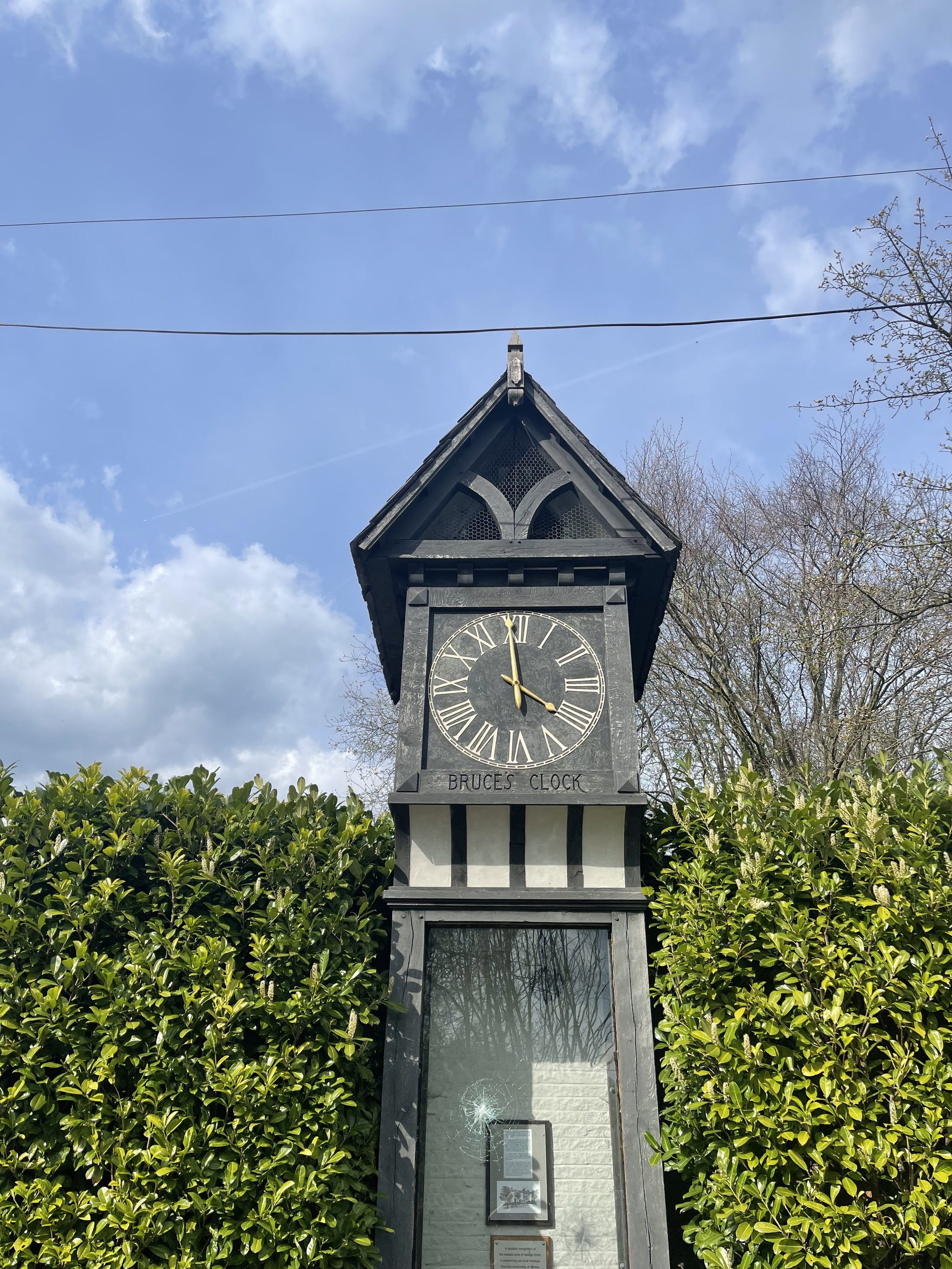
On the home stretch, the Goyt Way makes for a relaxing, flat stroll—taking you passed landmarks such as Bruce’s Clock in Strines. In medieval times, Strines stood as a large hunting forest—The Forest of the Peak—before local gentry settled here during the Elizabethan period.

Bruce’s Clock was originally found on the grounds surrounding Strines Hall, with the comings and goings of local people ordered by the striking of its bell in days when clocks and watches were rare household acquisitions.

After briefly meeting back up with The Roman Lakes footpath, you’ll finally reach The Peak Forest Canal to make the last stretch back to Marple.
The Waltzing Matilda sometimes moors here, so keep an eye out if you’re looking to refuel on woodfired pizza.


SK WOODLAND TOUR
A trail so idyllic it’s hard to believe you’re a literal stone’s throw away from the M60…

Start: Woodbank Park, SK1 4JR
Distance: 4 miles
Duration: 1.5 hours
Elevation: 225 feet
Navigation: follow the route here

Having lived in Greater Manchester most of our lives, it always amazes us when we stumble across new-found territory just a stone’s throw away from our old stomping grounds. This route that links up to Midshires Way and Alan Newton Way is one of them!
Named after Stockport’s Olympic medal-winning cyclist, The Alan Newton Way provides a safe off-road route from Marple to Stockport via the Goyt Valley and towards the town centre.

Expect quiet, old farm lanes, a forgotten hall and a wonderful little detour back through the Woodbank’s woodland. We stopped off at Chadkirk for a quick refuel and a wander around Marple Garden Centre. Starting the route from this end means you’ll be able to have a pitstop at Pear Mill’s Vintage Emporium - a must-visit for anyone yet to have a nosey.

To extend the route, you can follow the Way to Etherow Country Park, or join up with the Middlewood Way at Chadkirk.
For us, the highlight came in discovering Goyt Hall Farm, one of Stockport’s many small halls… but due to its remote location, one of the prettiest. This Grade II listed half timbered mansion-house was built around the same time as the popular Bramall Hall. Today, it’s a working farm and stables surrounded by gorgeous bluebell-dotted woods and fields.

CHADKIRK LOOP
Just a short detour off the A6 in Stockport lies one of Greater Manchester’s best leisurely walks…

Start: Chadkirk Chapel, SK6 3LB
Distance: 6.29 miles
Duration: allow approx. 2 hours
Navigation: follow our GPS route
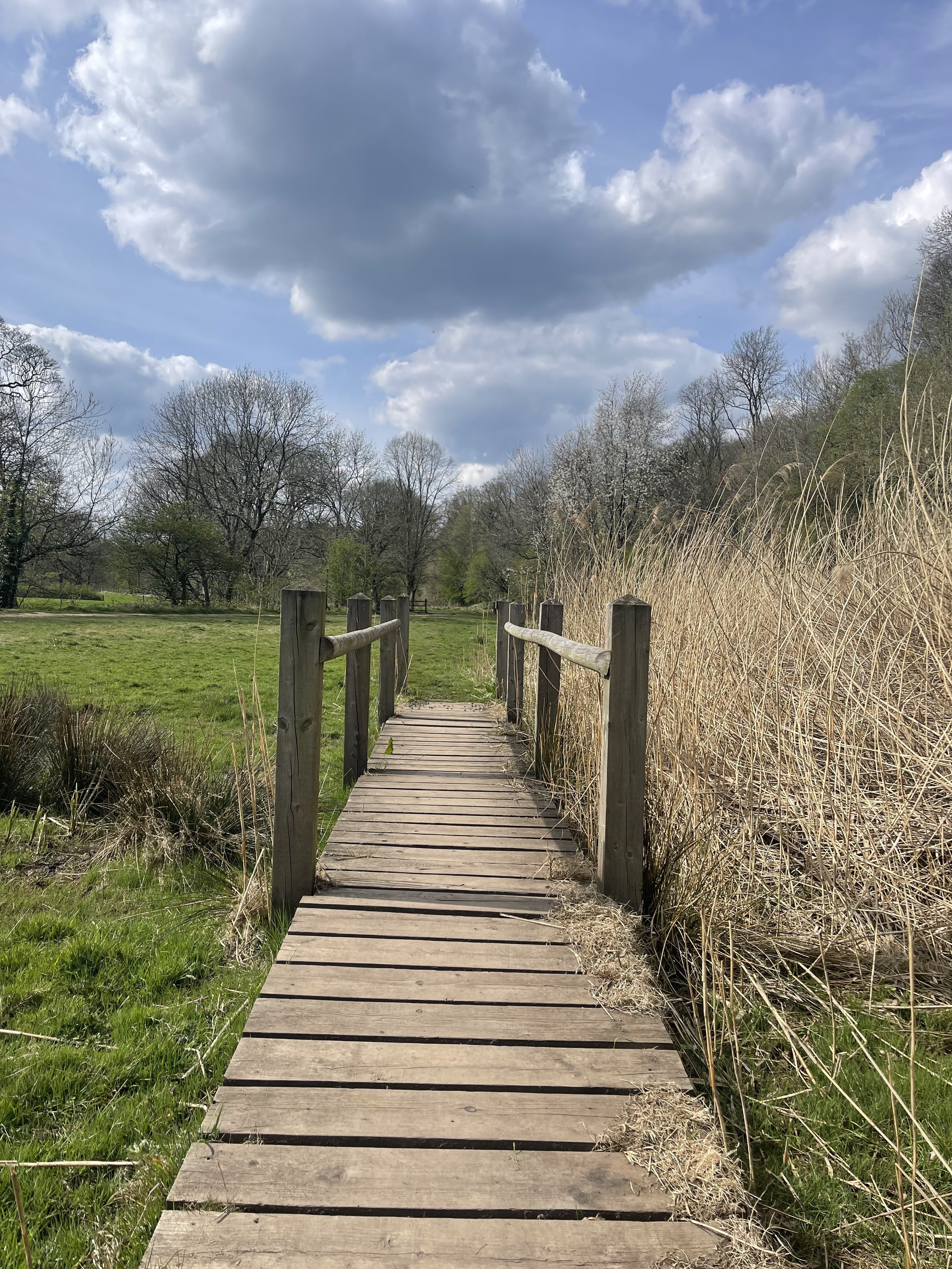
If you’re local to the area, you’ll know that this isn’t exactly a walk in the country - but it is it’s only little patch of countryside haven amidst Stockport’s urban landscape. The flat, accessible paths around Chadkirk Chapel make it great for those with four-legged pals and kids in tow, while the walk up to the canal makes for a great alternative if you’re looking to extend the walk and get some extra steps in.

Around the estate, you can relax in the peacefulness of the grounds surrounding the chapel and learn more about its history. If you’re following our route, you can bask in the picturesque woodland as you head up to the Peak Forest Canal before stopping to refuel at Dobbie’s on the home stretch.
Chadkirk was once an ancient settlement dating back to the 15th century, and a quick walk around the grounds will have you feeling like you’ve been transported to a different time.

As you venture up towards the Peak Forest Canal, you’ll find a blanket of wild garlic across the woodland floor. The leaves are edible and can be cooked for a mild garlic flavour. If you feel like giving foraging a go, why not check out our wild garlic pesto recipe?

To see the wild garlic in bloom, April or May is the best time to visit.
Happy exploring!

LYME WOODLAND TO POYNTON COPPICE
Rich in wildlife, Chorlton Coppice is classed as an ancient woodland — leading visitors from the Middlewood Way into the heart of the coppice

Start: Lyme Park, SK12 2NR (Alternatively, you can complete the walk in reverse by parking for free at The Coppice)
Distance: 4.5 miles
Elevation: 575 feet
Duration: allow approx. 2 hours
Navigation: follow the walk step-by-step here

It’s not news that we love walks that link up with The Middlewood Way. With 11 miles of traffic-free paths, we love hopping on here whenever we visit Stockport-way for a little mooch.
We’ve passed Poynton Coppice a few times along the way — and after realising we could walk there from our other favourite landmark in this neck of the woods, Lyme Park, we knew we had to give it a go.

Our favourite part about this part of Greater Manchester are the many off-road transport links that link up with each other. On this particular journey to the Coppice, we walked along The Middlewood Way and The Macclesfield Canal — both offering great links across Stockport.

Poynton Coppice is pretty at any time of year, with swooping trees canopying your every move. Many areas of woodland across the UK are called ‘Coppice’, ‘Copse’ or ‘Copy’ from the French word ‘couper’, meaning 'to cut’.
Traditionally, coppicing provided a continual supply of wood — a traditional method of woodland management which involves cutting young tree stems to near ground level for optimal regrowth.

Fancy a mooch in the woods this weekend? Follow the walk here

ETHEROW TO WERNETH LOOP
Discover Greater Manchester’s best hidden gems on this multiple-country park woodland walk

Start: Etherow Country Park, SK6 5DJ
Distance: 9 miles
Duration: 4 hours
Elevation: 1,500 feet
Navigation: follow the route here

Fancy experiencing all the seasons in one day?
Well, you're in luck, because this walk from Etherow Country Park to Werneth Low Country Park and confused mid-winter weather is what Great Manchester does best.
But don’t worry, with stunning scenery throughout and a dash of history thrown in for good measure, this walk is guaranteed to be a crowd-pleaser.

Our journey begins at Etherow Country Park — one of Britain’s first country parks. With 240 acres of greenspace, this place has an abundance of wildlife… and a waterfall you don’t want to miss!
But don't get too distracted by the fauna, because we've got a hill to climb. Yup, after a short stroll around the Keg Pool its time to climb up to Werneth Low Country Park.
Along the way, take a moment to catch your breath and admire the stunning panoramic view. Once atop The ‘Low, you’ll be quickly rewarded with immense views all across Manchester, the Peak District National Park, and the Cheshire Plain.

History buffs, we've got a couple of landmarks for you to check out. The first is the Werneth Low War Memorial, which was erected in 1921 to honor the soldiers who died in the First World War. It's a stunning monument, made of granite and topped with a bronze figure of a soldier.
After resting your legs and taking in the views, we make our way through the woodlands around Charlesworth and Broadbottom — each nothing short of idyllic. The trees are tall and imposing, the paths are winding and mysterious, and the wildlife is abundant. And if you’re up for a detour, the other landmark to check out is the Broadbottom Viaduct, which spans the valley between Broadbottom and Mottram.

Now, I know what you're thinking: a viaduct doesn't exactly sound like the most thrilling pit stop in the world. But trust me, this one is a real beauty. It was built in 1842, it's made of brick, and it has 27 arches. If you're an aspiring artist or photographer, this is the perfect spot to flex your creative muscles.
So, there we have it: a string of local country parks in one gorgeous route.
As local routes go, this one is a true belter.

Ready to follow along? Follow the route here
KERRIDGE HILL LOOP
Discover the beauty of Cheshire from up above with one of the best walks near Greater Manchester
Start: Pool Bank Car Park (Free Parking), SK10 5PS
Distance: 6.88 miles
Duration: 2-3 hours
Elevation: 1,000 feet
Navigation: follow the route here
Looking for a bit of history on your next trip outdoors? Look no further than this uphill hike around the Cheshire countryside. Not only does this walk provide excellent views that sweep right across the surrounding area, but you’ll also pass White Nancy fairly early on — a memorial site atop Kerridge Hill, built to commemorate the victory of coalition forces at the Battle of Waterloo.
With its comically shaped physique, White Nancy isn’t your typical historical landmark. Thanks to its lofty position, the site White Nancy sits on had been used as a warning beacon of invasion for centuries, featuring other small structures before Nancy took up residence.
In 1817, the Gaskell family of Ingersley Hall built the structure you see today, in belated commemoration of the victory at Waterloo, 1815. Originally, White Nancy had a door and was used as a summerhouse, but was soon sealed off due to vandalism over the early 20th century.
Whether you’re here for the views or the stories of yesteryear, you’re sure to be taken aback by the undisturbed peacefulness of this route. On a clear day, you can see as far as Snowdonia, Liverpool’s coastal line and the windmills off the Wirral peninsula.
After admiring the views surrounding White Nancy, walking across Kerridge Hill is a must. The route’s quite steep in parts — but the views? So worth it.
So if you’re after a walk that offers incredible views every way you turn, make sure you stop by and see our Nancy soon. With multiple footpaths, woods and fields to explore nearby, you can easily extend this route into a full date out.
Fancy stopping by to see Nancy soon? Follow the route here

FLETCHER MOSS
This tranquil stretch of Didsbury is perfect for recharging after a busy week in the office.

Start: Chorlton
Distance: 6.13 miles
Elevation: 75 feet
Duration: allow approx. 2 hours
Navigation: follow the trail here
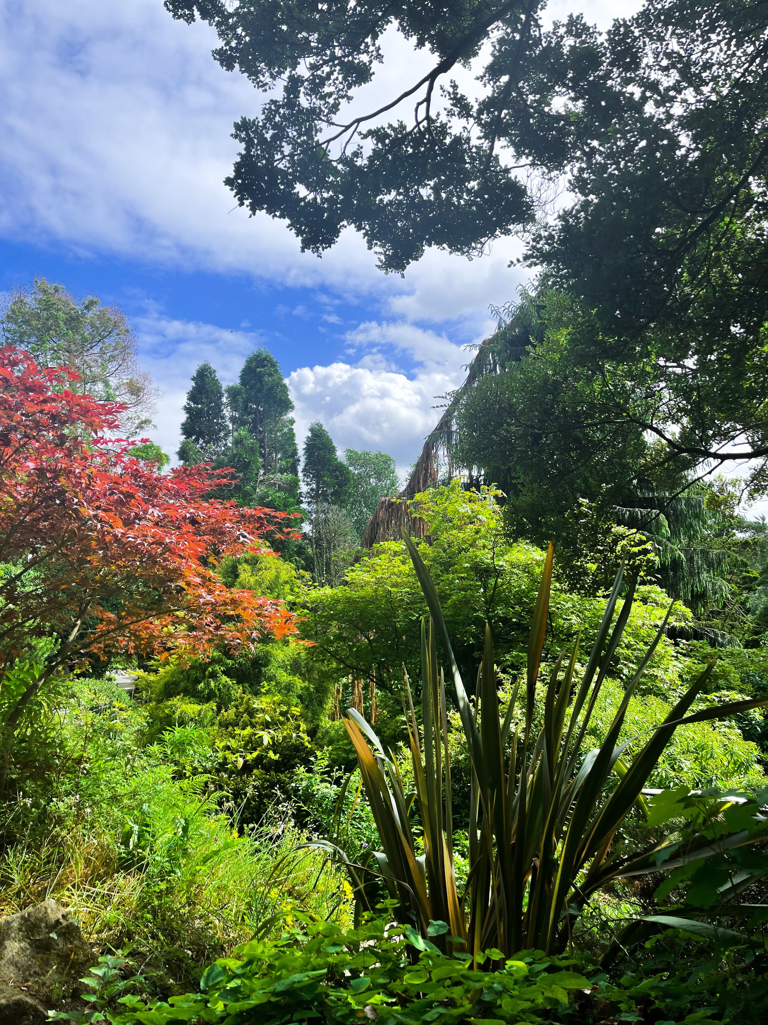
Tucked away between numerous Mancunian green spaces, you’ll find Fletcher Moss Botanical Gardens in all of its unsuspecting glory. It’s an oasis, that’s for sure, and given its location just a stone’s throw away from lively South Manchester, an unexpecting one at that.
Better yet, entry into this incredible garden and surrounding woodland is completely free.

There are several different sections and terrains to cover, from the nature reserve itself, to the Parsonage gardens, river Mersey, a trail through the woods… and most people’s favourite: the rockery.
The rockery is well-maintained and a real gem to escape the hustle and bustle of city life for an hour or so. The Old Parsonage is the second oldest building in Didsbury and has only ever been lived in by two of the church ministers.
Back in 1915, Fletcher Moss gifted the house and gardens to the City of Manchester and much of the present layout was designed by Moss himself and his mother.
Today, you’ll find a large number of ornamental trees, a striking neo-Norman stone arched gate and numerous species of wildlife.

Thanks to the park’s clever layout, the stunning rock gardens are protected from the elements — home to a south-facing slope for shelter, perfect for sitting in the garden on a Mancunian summer’s day.
Aside from its perfectly groomed gardens, Fletcher Moss is home to an array of wildlife, and even a Bug Hotel.

And in true Manchester style, you’ll even find a little slice of hipster heaven in the form of The Alpine Tearoom, selling up a gorgeous selection of alcoholic spirtzers, NQ-approved hot drinks and tasty food.

Our route starts in Chorlton-cum-Hardy, meaning you can take in numerous hidden South Mancunian scenic delights in one stretch. With a short stroll along the River Mersey en-route, it’s a calming walk with plenty to see along the way, making it one of our best walks to set off on in Manchester.

Like what you see? Follow the route step-by-step here
POYNTON COPPICE
Rich in wildlife, Poynton Coppice is classed as an ancient woodland — leading visitors from the Middlewood Way into the heart of the coppice
Start: Lyme Park (alternatively you can complete the walk in reverse by parking at The Coppice)
Distance: 4.23 miles
Elevation: 430 feet
Duration: allow approx. 2 hours
Navigation: follow the walk step-by-step here
It’s not news that we love walks that link up with The Middlewood Way. With 11 miles of traffic-free paths, we love hopping on here whenever we visit Stockport-way for a little mooch.
We’ve passed Poynton Coppice a few times along the way — and after realising we could walk there from our other favourite landmark in this neck of the woods, Lyme Park, we knew we had to give it a go.
Our favourite part about this part of Greater Manchester are the many off-road transport links that link up with each other. On this particular journey to the Coppice, we walked along The Middlewood Way and The Macclesfield Canal — both offering great links across Stockport.
Poynton Coppice is pretty at any time of year, with swooping trees canopying your every move. Many areas of woodland across the UK are called ‘Coppice’, ‘Copse’ or ‘Copy’ from the French word ‘couper’, meaning 'to cut’.
Traditionally, coppicing provided a continual supply of wood — a traditional method of woodland management which involves cutting young tree stems to near ground level for optimal regrowth.
Fancy a mooch in the woods this weekend? Follow the walk here
ALAN NEWTON WAY
A trail so idyllic it’s hard to believe you’re a literal stone’s throw away from the M60…
Start: Pear Mill, SK6 2BP
Distance: 5.18 miles
Duration: 2 hours
Elevation: 200 feet
Navigation: follow the route here
Having lived in Greater Manchester most of our lives, it always amazes us when we stumble across new-found territory just a stone’s throw away from our old stomping grounds. The Alan Newton Way is one of them!
Named after Stockport’s Olympic medal-winning cyclist, The Way provides a safe off-road route from Marple to Stockport via the Goyt Valley and towards the town centre.
Expect quiet, old farm lanes, a forgotten hall and a wonderful little detour back through the Woodbank’s woodland. We stopped off at Chadkirk for a quick refuel and a wander around Marple Garden Centre.
Starting the route from this end means you’ll be able to have a pitstop at Pear Mill’s Vintage Emporium - a must-visit for anyone yet to have a nosey.
To extend the route, you can follow the Way to Etherow Country Park, or join up with the Middlewood Way at Chadkirk.
For us, the highlight came in discovering Goyt Hall Farm, one of Stockport’s many small halls… but due to its remote location, one of the prettiest. This Grade II listed half timbered mansion-house was built around the same time as the popular Bramall Hall. Today, it’s a working farm and stables surrounded by gorgeous bluebell-dotted woods and fields.
Fancy giving this trail a go? You can follow our route step-by-step here

WHALEY BRIDGE INCLINE
With neighbouring Buxton and Hayfield (home of Kinder Scout) often taking the peak-shaped glory, Whaley Bridge can be overlooked as a place to grab your boots and go for a walk — and that’s part of the reason it’s one of our favourite places to explore.

Start: Canal Street Free Carpark, SK23 7LX
Distance: 6.9 miles
Elevation: 1,000 feet
Duration: allow 2-3 hours
Navigation: follow our route here

Just a 20 minute drive from Stockport and only 40 from Manchester, Whaley Bridge is one of the most accessible Peak District villages to visit from our neck of the woods — but that doesn’t mean it loses any of its charm. While many walkers use the village as a great base to explore other more challenging routes, Whaley itself has many idyllic spots that’re often overlooked by tourists and ramblers alike.
Whether it’s a walk along Bugsworth Basin towards Eccles Pike, or a trip to nearby Goyt Valley, Whaley Bridge has much to offer in untouched countryside and gorgeous landscapes to explore.

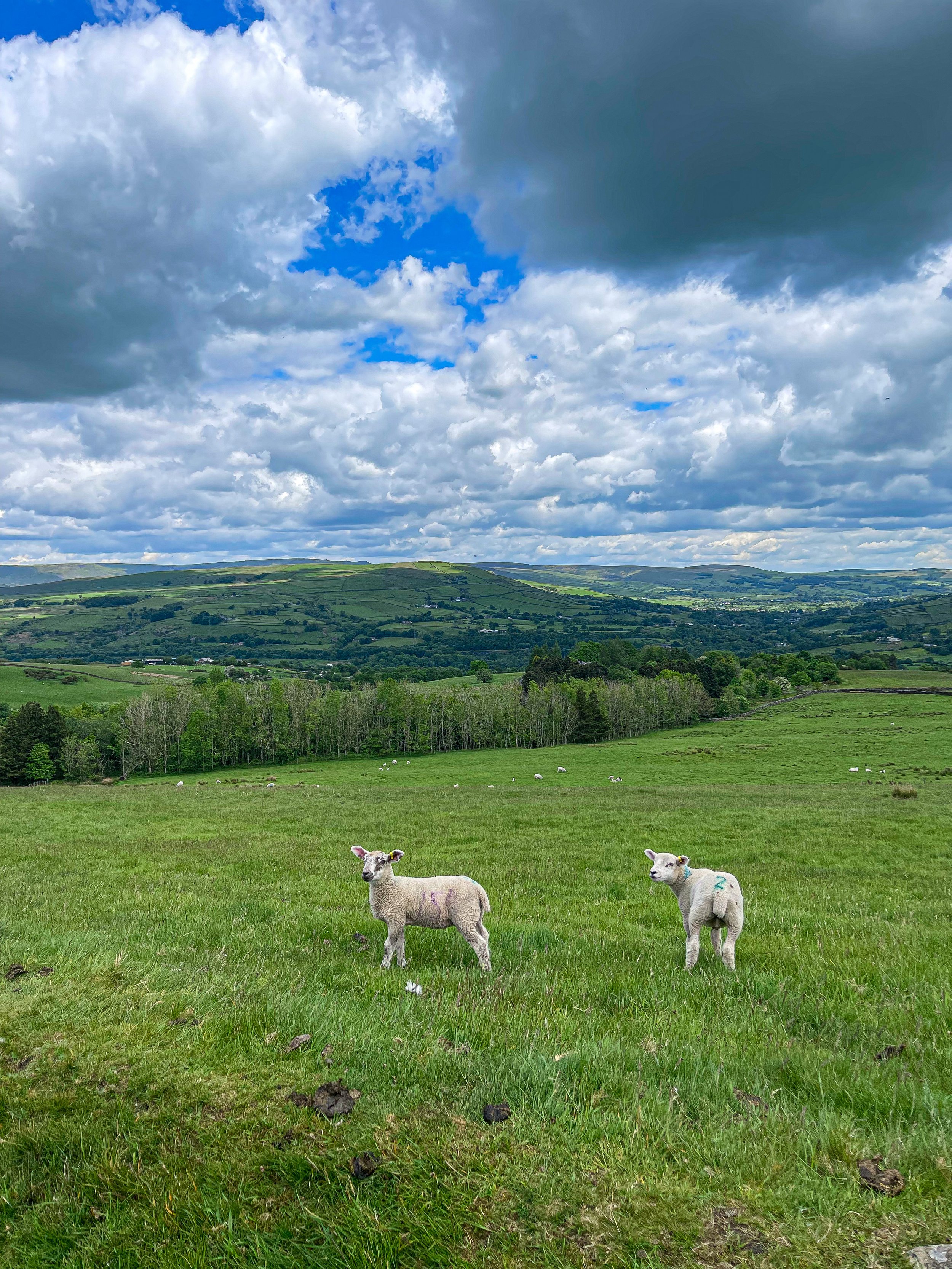
But for us, the true showstopper in Whaley is its own surrounds. Due to the popularity of other routes nearby, we pretty much had the entire trail to ourselves (except for plenty of sheep… and even some llamas!)

Our walk starts at the Whaley Bridge Canal Basin, which you can follow along to Marple one way and Macclesfield the other. Following the incline, you’ll come across plenty of stiles and well-marked paths through idyllic farmland and fields up to Kettleshulme, with a well-earned pitstop at The Swan Inn mid-route.

On the homeward leg, you can stop off at Todd Brook Reservoir and Brookfield Pond nature reserve for a final pit stop and a much-deserved refuel.

Fancy giving this walk a go? Follow one of the High Peak’s best routes here

THE TORRS CIRCULAR
An idyllic 10 mile loop taking in the best of Stockport’s forgotten history
Distance: 10.5 miles
Duration: allow approx. 4 hours
Elevation: 1,200 feet
Start: Peak Forest Canal, Marple SK6 7NP
Navigation: follow the route here

On initial glance, New Mills may look like any ordinary Peak District village: small, picturesque with little much-to-do around the town. Venture just a few steps downwards towards the River Sett, and you enter another landscape entirely.
Below the hustle and bustle of the main shopping centre lies New Mill’s (not so) hidden gem: The Torrs. We’ve done this walk a few times, and every time we’re amazed by the astounding natural gorge that lies below.
Expect colourful cliffs, enormous viaducts and a long bridge that transports you to the Goyt Way; making for one of the best walks in Derbyshire.
The Torrs itself makes for a great short circular route if you’re not planning on venturing far, but our trail starts and ends in nearby Stockport. From Marple, you’ll head towards The Roman Lakes and passed the site of Mellor Mill Ruins. Once a shining star or the Oldknow Empire, Mellor Mill was the biggest spinning mill the world had seen during its time of construction.
What remains of the mill have since been taken over by the natural world, making for a gorgeous pitstop by the Peak Forest Canal and River Goyt.
Passing the ruins, you’ll make the ascent towards Mellor Cross—a local landmark on Cobden Edge. The cross was originally erected in March 1970, made by a carpenter local to the area. From The Cross, you’ll reach Mellor Moor, where you’ll be rewarded with views across the western edge of the Peak District and the Cheshire Plain.
The moor’s umpteen tracks date back to prehistoric Old Mercian trackways, and make great aids for exploration. The line of an ancient trackway is said to be the route of monks and pilgrims, with waymarkers signifying Old Mercian landmarks and monasteries.
Descending from the moorland, we head towards New Mills where you can stop for a well-earned refuel. The town boasts an impressive mix of independent shops, cafes and pubs, perfect for that much-needed pitstop before the homeward leg. We stopped off at Clockwork Cafe, which has all your caffeine (and Derbyshire Oatcakes!) cravings covered.
After a refuel is where you’ll be greeted with the trail’s main event: The Torrs Millennium Walkway. This 175-yard aerial walkway spans the cliffsides above the River Goyt, with links to many walking and cycling routes should you choose to travel a different way home. New Mills Heritage Centre provides maps and guides for several nearby walks, including the iconic Kinder Trespass Trail.
In 1932, around 500 walkers from Manchester trespassed en masse from Hayfield to Kinder Scout to secure access right to open country for all to enjoy. Back then, walkers across England and Wales were denied access to areas of open country—luckily for us, the trespass helped pave the way for the establishment of the Pennine Way and other long-distance footpaths enjoyed today.
Fancy following in their footsteps? You can follow our Hayfield to Kinder Scout route here.
On the home stretch, the Goyt Way makes for a relaxing, flat stroll—taking you passed landmarks such as Bruce’s Clock in Strines. In medieval times, Strines stood as a large hunting forest—The Forest of the Peak—before local gentry settled here during the Elizabethan period.
Bruce’s Clock was originally found on the grounds surrounding Strines Hall, with the comings and goings of local people ordered by the striking of its bell in days when clocks and watches were rare household acquisitions.
After briefly meeting back up with The Roman Lakes footpath, you’ll finally reach The Peak Forest Canal to make the last stretch back to Marple.
The Waltzing Matilda sometimes moors here, so keep an eye out if you’re looking to refuel on woodfired pizza.
Fancy giving this walk a go? You can follow our GPX directions here
CHADKIRK LOOP
Just a short detour off the A6 in Stockport lies one of Greater Manchester’s best leisurely walks…
Start: Chadkirk Chapel, SK6 3LB
Distance: 6.29 miles
Duration: allow approx. 2 hours
Navigation: follow our GPS route
If you’re local to the area, you’ll know that this isn’t exactly a walk in the country - but it is it’s only little patch of countryside haven amidst Stockport’s urban landscape. The flat, accessible paths around Chadkirk Chapel make it great for those with four-legged pals and kids in tow, while the walk up to the canal makes for a great alternative if you’re looking to extend the walk and get some extra steps in.
Around the estate, you can relax in the peacefulness of the grounds surrounding the chapel and learn more about its history. If you’re following our route, you can bask in the picturesque woodland as you head up to the Peak Forest Canal before stopping to refuel at Dobbie’s on the home stretch.
Chadkirk was once an ancient settlement dating back to the 15th century, and a quick walk around the grounds will have you feeling like you’ve been transported to a different time.
As you venture up towards the Peak Forest Canal, you’ll find a blanket of wild garlic across the woodland floor. The leaves are edible and can be cooked for a mild garlic flavour. If you feel like giving foraging a go, why not check out our wild garlic pesto recipe?
To see the wild garlic in bloom, April or May is the best time to visit.
Happy exploring!

THE ROMAN LAKES, SK
A short but scenic stroll around Stockport’s industrial heritage and hidden wildlife
A short but scenic stroll around Stockport’s industrial history and hidden wildlife

Start: Roman Lakes, Marple, SK6 7HB
Distance: 5.2 miles
Duration: 2 hours
Facilities: Carpark, Toilets, Tea Room
Navigation: follow the route here

Tucked away down a quiet country lane in the picturesque Goyt valley, this circular walk takes you through a forgotten part of Stockport’s history.
In recent years, archeological work has been underway and transformed the spaces surrounding into a time gone-by, offering ample opportunity to explore with both easy and demanding routes on offer through the surrounding woodland and bridleways.

The Roman Lakes has a rich heritage stretching back to the 18th century. Excavated by the Mellor Archeological Trust, the newly unearthed sites allow you to walk around the remains of the mighty Mellor Mill — a place which, at its peak, employed more than 550 people.
Built by known industrialist Samuel Oldknow, it was the largest cotton mill in the world when it was completed in 1793, with an undeground tunnel network that connected millworkers to their nearby homes.

With gardens, lakes and woodland every way you turn, the manmade lakes you see today were originally millponds formed by diverting the River Goyt.
In 1892, the mill was destroyed by fire and the surrounding beauty spots were turned into a pleasure park with rowing boats, a dance hall and amusements that attracted thousands of people from the surrounding towns and villages — a far cry from the quiet spot we see today.

Today, the lakes are used for fishing and canoeing, while the surrounding valley provides a walker’s paradise — with the option to follow all types of distances and difficulties around the surrounding trails and bridleways.
Fancy learning a bit more about the area? Free history and nature trail leaflets are available from the tearoom — a perfect place to stop off an soak up Stockport’s history.

WOODFORD CIRCULAR
An atmospheric, short stroll around Woodford’s abandoned Aerodrome
As atmospheric walks go, this one’s certainly up there.

Start: Old Hall Lane
Distance: 2.5 mile circular
Ascension: 50 feet
Pitstops: Notcutts Garden Centre, The Unicorn
Navigation: follow the route here

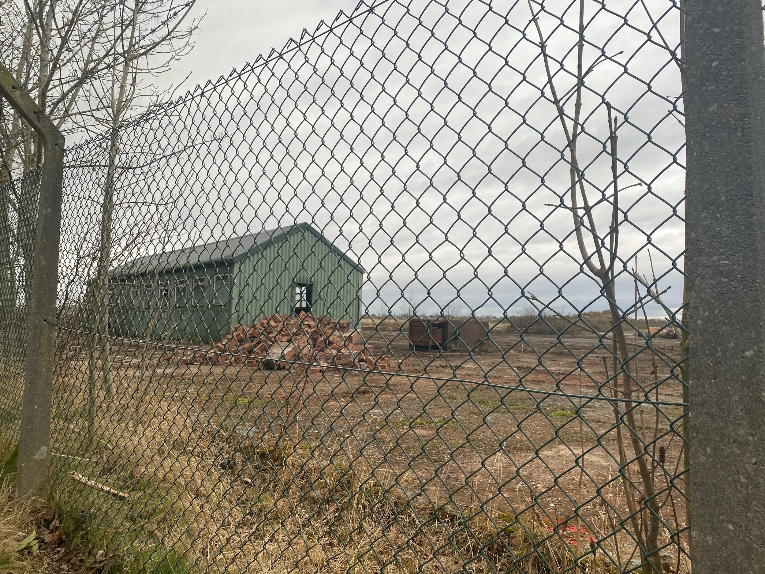
Call us novices, but until we took a venture around this abandoned Aerodrome in Woodford (near Stockport), we’d never followed a public footpath that meanders through a golf course before.

Aside from watching out for golfers’ swings, we were pleasantly surprised by the mix of urban and natural landscapes — blending into one to create a pretty spooky (but nontheless interesting) trail so close to home.

Woodford Aerodrome first opened just after the First World War and became an important production centre for military aircraft during the Second World War. Notable planes made here include the Arvo Vulcan and the Arvo Lancaster — and most of its remains are still standing, waiting for passersby to explore but for a tiny fence blocking the view.
If you’re looking for one of the best short walks close to Stockport perfect for the whole fam, then a trip to Woodford is always a good shout!

“All truly great thoughts are conceived while walking. ”
UPHILL CHALLENGES:


WALKS WITH WATERFALLS:


